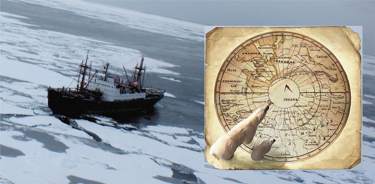
From Arctida to the Present-Day Arctic
The Arctic has long ceased to be a "land of polar bears and aurorae." Today, this territory is a crossing point of the economic and geopolitical interests of many countries, including those without access to the Arctic coast. The subject of the recently enhanced struggle for the Arctic is the huge oil and gas reserves concentrated primarily on the continental Arctic shelf and the availability of strategically important transport arteries such as the Northern Sea Route, whose role will only increase in the case of global warming. The demarcation of the Arctic shelf might have a huge impact on the geopolitical situation in the future. More fuel to the fire comes from the absence of a clearly defined legal status of national borders in this region.
By international law, today the continental shelf area for countries with maritime borders is 200 nautical miles from their coasts. However, if a country can prove that the shelf of the Arctic Ocean is an extension of its continental platform, then, according to the UN Convention on the Law of the Sea, this territory is recognized as this country’s property. Today, Russia is preparing to prove its right to expand the borders of its polar economic zone by substantiating the inclusion of the Mendeleev and Lomonosov underwater ocean ridges into this zone.
The currently available geophysical and geological data, including the results of underwater drilling and sampling at oceanic basement outcrops, allow scientists to identify the age of geological structures on the floor of the Arctic Ocean and to reconstruct the evolution of the paleocontinents from the Precambrian to early Cenozoic. These results make it possible to trace the formation of the modern continental margin of Eurasia and confirm the continental nature of the "controversial" oceanic ridges. These data will substantiate Russia’s claims in its application to the United Nations; if it is approved, Russia’s Arctic continental shelf will increase by an area twice that of France
The Arctic Ocean through the eyes of a geologist
“The Northern ocean, by the way, is a spacious field
where Russian glory can grow, combined
with an unprecedented benefit…”
Mikhail V. Lomonosov
With an area of about 15 million km2, the Arctic Ocean is the smallest and the youngest of the Earth’s oceans. Its main specificity is that most of the ocean floor is occupied by a continental shelf (over 45%) and offshore continental margins. An increasing interest in the Arctic Ocean is primarily accounted for by geopolitical issues and challenges of managing mineral resources on the Arctic shelf, as well as by environment related problems, climate changes, and permafrost degradation.
Solving these problems largely relies on our knowledge of the geological structure of the Arctic Ocean basement, including the structural features of the Arctic sedimentary basins with respect to their oil and gas potential.
Geological knowledge also provides substantial insights into the correlation between continental margins, including submerged shelves, and different structures largely characterized by terrain features of the Earth’s crust but lying at a considerable distance from the mainland, which appears vital in solving the problem of establishing the outer limits of Russia’s and other Arctic states’ sectors of the continental shelf
THREE THOUSAND KILOMETERS ACCROSS TAIMYR PENINSULA(from a poem by Lana Grig)
The author of this article is familiar with the Arctic firsthand. While a student, back in 1974, he made his first trip to the Chelyuskin peninsula during his summer practice work and learned his lessons in the geology of the Arctic Region from the geological routes on the shores of the Kara and Laptev Seas, under the supervision of I. D. and A. L. Zabiaka, both having a Cand.Sci. degree in geology and mineralogy and a wealth of practical experience. Many interesting facts about the geology of the Arctic he learned from the lectures of the famous polar geologist, professor L.V. Makhlaev. And then he, in his own words, was lucky enough to be engaged for four decades in the geological research and studies of a sparsely populated part of our planet with an extremely harsh climate.
The field practice of a graduate student made the beginning of almost yearly Arctic expeditions, in which he took part first as a young professional, and later in the capacity of a Candidate and Doctor of Sciences. Valery Vernikovsky prepared his Cand.Sci. thesis under the supervision of a renowned geologist N. L. Dobretsov. It was dedicated to the role of metamorphism in ore-grade gold mineralization of the northeast Taimyr, while his Dr.Sci. research focused on the geodynamic evolution of Taimyr and its relationship with other ancient blocks in the Arctic. The works have attracted attention of many outstanding scientists, true experts in the Arctic geology: V. E. Khain, N. A. Bogdanov, L. P. Zonenshain, and L. M. Natapov, which resulted, eventually, in the joint development and publication of geological and tectonic maps of the Arctic region and scientific articles.
The part of life spent together with his colleagues in the tents next to glaciers have cumulatively added up to several years, and records on their walking routes across the Taimyr Peninsula alone exceeded three thousand kilometers! In those years, vehicles used to be simple, not very fast, but reliable. Geologists had all-terrain vehicles to navigate through the Taimyr tundra,and inflatable boats to they used to float along the rivers and across the lakes.
The onset of the era of helicopters commenced only in the late 1990s; it first became popular with the international expeditions with the participation of several dozen researchers from different countries. In recent years, apart from the helicopters, Arctic geologists have been using not only but ice-breakers and even submarines! Today, they have at their disposal completely different technical capabilities, fundamentally new methods and technologies for data analyses. And only the Arctic as it is - an unforgettable land of contrasts – has remained the same ...
The geology of the Arctic region and its “cold heart,” the Arctic Ocean, has long appealed to Russian scientists. The increased geological knowledge and geophysical data accumulated over the past decades, along with the application of innovative analytic techniques, has resulted in the generation of new geological and tectonic maps, geodynamic models, paleo-tectonic reconstructions, providing novel insights into the geological history and tectonic evolution of this region.
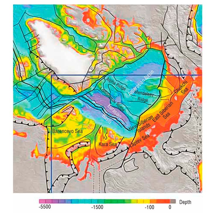
The Novosibirsk center for paleomagnetic studies with cryogenic magnetometer has greatly facilitated works on paleotectonic reconstructions and geodynamic models. The scientists can now determine the direction of the ancient natural remanent magnetization (NRM) of rocks, their paleomagnetic poles position and, given that the age of rock is known, identify the positional relationship of the continents and individual terranes (fairly large crustal blocks bounded by faults).
In particular, paleomagnetic data collected during the field studies on the Severnaya Zemlya archipelago provided novel evidence consistent with the tectonic and geodynamic reconstructions, those built earlier relying on structural and geochronological data (Vernikovsky, 1996), and revealed the kinematics (motion) of the Kara microcontinent and its collision with the Siberian paleocontinent (Metelkin et al., 2005).
Today, it has been ascertained that the Arctic Ocean continues to change in size, which is related to both the configuration of the surrounding paleocontinents and its geographical position on the globe. In this context, in the Silurian-Devonian (430-400 million years ago), the configuration of the ocean space between Baltica (East European Platform), Laurentia (North American Craton) and Siberia in many ways resembled the present-day delineation of the Arctic Ocean, the only difference being its location on the equator! Now it becomes apparent why Early Silurian thermophilic corals, known to have formed 430 million years ago, were found on Kotelny Island (the New Siberian Islands, 76° N) in the habitat conditions similar to those presently characteristic of the Australian Great Barrier Reef!
In search of Arctida
The existence of the ancient Precambrian continent, often called Arctida, has been inferred by many researchers studying geological structures in the Arctic (Zonenshain, Natapov 1987). The paleocontinent breakup resulted from rifting processes, while its individual plates and terranes either became subsequently overlain by the sediments transported from the continental margins and ocean, or were accreted to the fold belts along the ocean’s periphery (on the Taimyr Peninsula, in Chukotka, Alaska, etc.). It stands to reason that the Kara microcontinent is but one of the fragments of the paleocontinent.
In order to develop more detailed kinematic models and paleotectonic reconstructions, it is required to utilize the wealth of paleomagnetic database for the entire Arctic region. In recent years, the researchers from the A.A.Trofimuk Institute of Petroleum Geology and Geophysics (IPGG) SB RAS (Novosibirsk) and Novosibirsk State University (NSU) have been able to obtain new paleomagnetic and geochronological data on the igneous and sedimentary rocks of the Severnaya Zemlya and Novaya Zemlya archipelagos, Franz Josef Land, De Long archipelago, New Siberian Islands, and Taimyr Peninsula and contiguous areas.
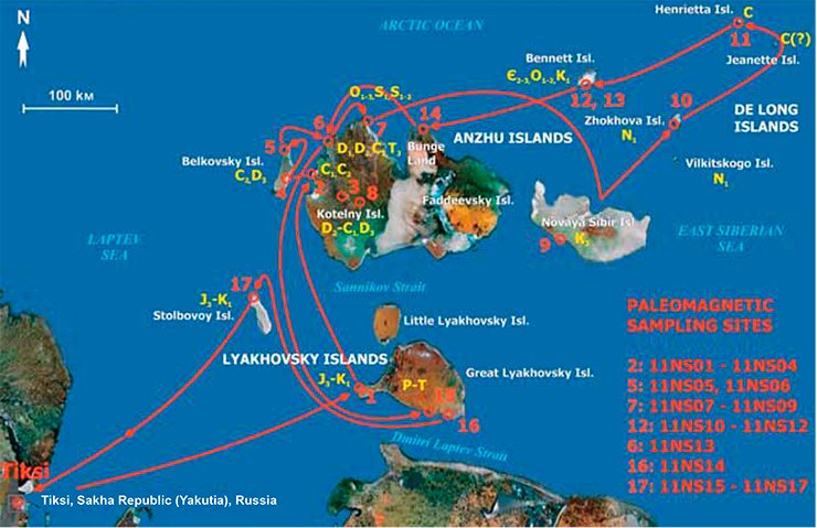
These data were collected, in particular, during the unique international expeditions organized in 2011 and 2013 by the A. P. Karpinsky All-Russian Geological Research Institute, VSEGEI (St. Petersburg), with the use of the diesel-electric ship Mikhail Somov with an Mi-8 helicopter onboard. The integrated geological and geophysical studies were successfully carried out on the New Siberian Islands, including the De Long archipelago.
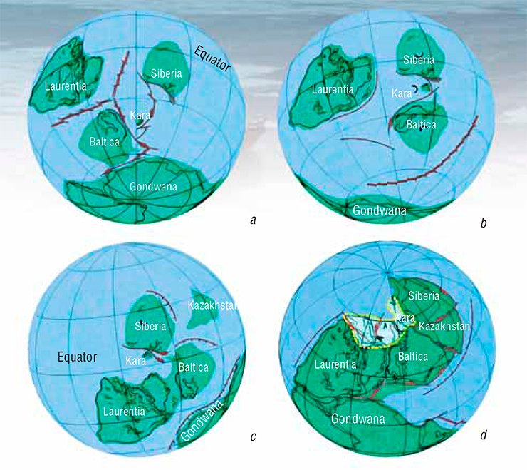
The new paleomagnetic data obtained for this region by a team from the IPGG SB RAS laboratory for geodynamics and paleomagnetism suggest that the rocks composing the area have been developing on the uniform Precambrian basement within the bounds of the New Siberian terrane since, at least, the early Ordovician (early Paleozoic) (Vernikovsky et al., 2013).
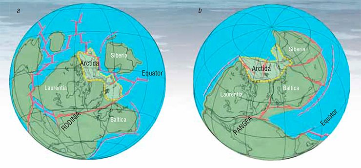
Using these data in combination with the key paleo-poles data for the continental plates of the circum Arctic Ocean margins made up by Laurentia (North America), Baltica (Eastern Europe) and Siberia has allowed for plate tectonic reconstructions that represent a record of positions of the continents and terranes amalgamated into the Arctida paleocontinent in the late Precambrian—late Paleozoic time period between 950–250 million years.
The illustration represents only two of the 14 reconstructions that match the configuration of the Arctida blocks existent 950 and 250 million years ago. During the time period spanning from Rodinia to Pangea supercontinents, Arctida is known to have changed its configuration, and its latitudes shifted from the equatorial to the near-polar domain, though the landmass placement between Laurentia, Baltica and Siberia persisted.
Thus, the completion of the major processes of the Arctic continental accretion proved coeval with the formation of Arctida II and supercontinent Pangea 250 million years ago, which was followed by the Jurassic-Cretaceous rifting. This stage is particularly associated with the onset of the formation of present-day Eurasian continental margin.
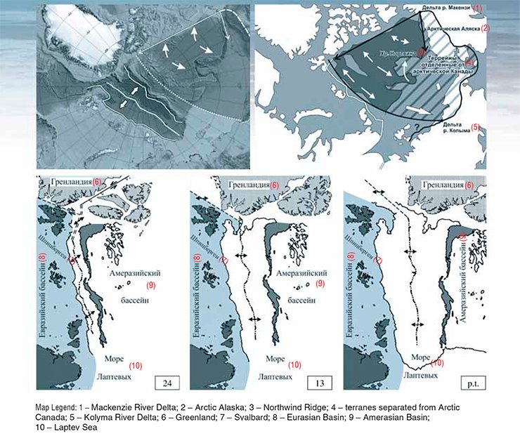
The process was triggered by the Chukchi-North Alaskan microplate breakup from the North American Craton, which led to the formation of the Canada Basin in the Arctic Ocean 140–120 million years ago, then followed by the closure of the South Anyui paleoocean, and, subsequently, by the fold-and-thrust belts developing in the direction from the New Siberian Islands through Chukotka and as far as the Brooks Range mountains in Alaska.
Concurrently, the seafloor spreading ceased in the Canada Basin and the spreading centers began their motion from the Atlantic to the Arctic Ocean. The process was accompanied, first, by some blocks rifting off the Alpha–Mendeleev rise and then, 55–54 million years ago, by the continental blocks of the Lomonosov Ridge, from the Barents-Kara continental margin due to the changing spreading zone and opening of the Eurasian Basin.
The incremented shelf to add value
The continental origin of the Lomonosov Ridge has hardly stirred any disputes lately, as there is lots of evidence supporting this assumption, including data obtained from drilling the area by American geologists in 2004, while with regards to the Mendeleev Ridge opinions still differ.
As is known, in December 2001, Russia made an official submission into the UN Commission on the Limits of the Continental Shelf, with a proposal to exend the Russian continental shelf area from the baseline of the Exclusive Economic Zone beyond 200 nautical miles (nmi), comprising most of the Lomonosov Ridge, Podvodnikov Basin, Mendeleev rise and, partly, the Makarov basin.
The restrictive criterion of 350 nautical miles from the baseline, contained in paragraph 5, Art. 76 of the UN Convention on the Law of the Sea 1982 was not applied therewith, though. This was done on the basis of para. 6 of the same article, which states that the 350 nautical miles limit does not apply to submarine elevations that are natural components of the continental margin, such as plateaux, rises, caps, banks and spurs (Continental shelf limits, 2000).
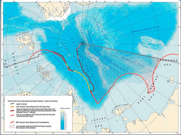
However, the UN Commission rejected Russia’s claim, with the statement predicated on the assumption that the Mendeleev Rise is a volcanic structure sitting on the ocean crust of plume nature, while the Lomonosov Ridge being a separate ridge was subject to the distance limit of 350 nautical miles, and thus, narrowing the potential area of the legitimate Russian shelf area in the Arctic to the lowermost limit.
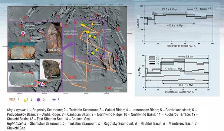
In order to study in detail the geological structure of the Mendeleev Ridge and the surrounding crustal blocks, Rosnedra oil company and its affiliate organizations (VSEGEI, VNIIOkeangeologia, Sevmorgeo et al.), conducted a high-latitude expedition using the research vessels and icebreakers, with the participation of research groups from RAS Institute and foreign scientists. So, the Arctic-2012 expedition with the with support of the Kapitan Dranitsin icebreaker and research submarine, was primarily aimed at examining and sampling the seafloor of the Mendeleev rise.
GBU-2/4000L drill rig was used for sampling the bedrock in the northern and southern parts of the Mendeleev rise, where three boreholes were drilled, and the research submarine was equipped with a manipulator mounted on its bottom. The sampling sites were located in areas close to escarps with the previously targeted outcrops of acoustic basement, relying on the video and seismic survey data.
The four of many other thus collected specimens of dolerite and basalt were used for petrographic descriptions and mineralogical analyses, as well as for further isotope studies, conducted to determine the age of rocks with the argon-argon method at the Sobolev Institute of Geology and Mineralogy (IGM SB RAS) analytical center, Novosibirsk. The isotope studies have revealed in the spectra of all samples of minerals the presence of an ancient component, to all appearances related to the time of rocks’ formation, dating approximately 472–467 million years, which is close to the Lower-Middle Ordovician boundary (Vernikovsky et al., 2014).
Along with the ancient component, younger age indicators were established in the spectra of a number of samples, which is accounted for by a huge amount of flood basalts during the plume events at the Paleozoic-Mesozoic boundary and in the Mesozoic. This allows us to ascertain that the age of basalt and dolerites collected from the Mendeleev Ridge slopes dates to the Early Paleozoic. This inference underpinned by the materials from the seismic survey expedition Arctic-2012, complemented by new geological and geophysical data for the New Siberian Islands, imply that the Precambrian basement of the continental block of the Mendeleev Rise to all appearances is similar to the continental block comprising the New Siberian Islands and De Long archipelago.
Moreover, it has become apparent that the Lomonosov and Alpha-Mendeleev ridges, including the Makarov and Podvodnikov basins between them, constitute a natural “bridge” built up of continental crust, connecting North American and Asian continents. These data will positively provide a weighty contribution to the substantiation of our country’s claim for an extension within the Russian Arctic sector’s area as far as the North Pole, owing to which Russia may be able to have an increment of an area over one million square kilometers to its Arctic shelf.
References
Vernikovsky V. A. Geodinamicheskaya evolyutsiya Taimyrskoi skladchatoi oblasti (Geodynamic Evolution of the Taimyr Fold–Thrust Belt). Novosibirsk: Sib. Otd. Ross. Akad. Nauk. 1996. 201 pp. [in Russian].
Vernikovsky V. A., Metelkin D. V., Tolmacheva T. Yu. et al. On the problem of paleotectonic reconstructions in the Arctic and the tectonic unity of the terrain of the New Siberian Islands: new paleomagnetic and paleontological data // Dokl. Ross. Akad. Nauk. 2013. Vol. 451. N 4. pp. 423–429 [in Russian].
Vernikovsky V. A., Morozov A. F., Petrov O. V., et al. New data on the age of dolerites and basalts of the Mendeleev Rise (the Arctic Ocean) //Dokl. Ross. Akad. Nauk. 2014. Vol. 454. N 4. pp. 431–435 [in Russian].
Glebovsky V. Yu., Kaminsky V. D., Minakov A. N. et al. The history of the Eurasian Basin of the Arctic Ocean from the results of a geohistoric analysis of the anomalous magnetic field// Geotektonika. 2006. N4. pp. 21–42 [in Russian].
Zonenshain L. P. and Natapov L. M. Tectonic history of the Arctic // Aktual’nye problemy tektoniki okeanov i kontinentov (Topical Problems of the Tectonics of Oceans and Continents). Moscow: Nauka. 1987. pp. 31–57 [in Russian].
Grantz A., Clark D. L., Phillips R. L. et al. Phanerozoic stratigraphy of Northwind Ridge, magnetic anomalies in the Canada basin, and the geometry and timing of rifting in the Amerasia basin, Arctic Ocean // Geol. Soc. Amer. Bull. 1998. Vol. 110. pp. 801–820.
Metelkin D. V., Vernikovsky V. А., Kazansky A. Yu. et al. Paleozoic history of the Kara microcontinent and its relation to Siberia and Baltica: paleomagnetism, paleogeography and tectonics // Tectonophysics. 2005. Vol. 398. pp. 225–243.
Metelkin D. V., Vernikovsky V. А., Matushkin N. Yu. Arctida between Rodinia and Pangea // Precambrian Research. 2015. Vol. 259. pp. 114–129.
Translated by N. Mzhelskaya


