Deep Geodynamics, or How the Earth’s Mantle Works
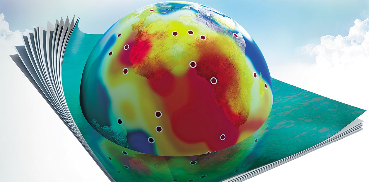
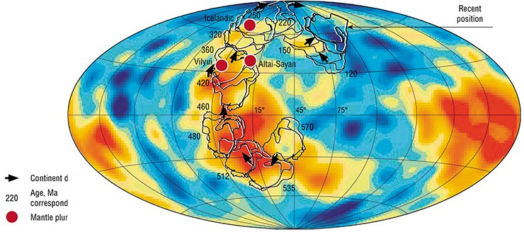
In the last 50 years, geology has experienced principal changes concerning the internal structure and geologic evolution mechanism of our planet. Thanks to achievements in seismotomography, scientists have found two huge areas of hotter substance stretching up to the core of the planet. It is interesting to note that their projections on the surface practically coincided with the so-called hot mantle fields which were recognized thirty years ago by Soviet geologists using indirect data. Those discoveries formed the basis for the deep geodynamics concept that connected the phenomena occurring on the Earth’s surface with processes happening in internal layers of our planet. This concept makes it possible not only to explain the repeated formation and break-up of supercontinents (given as an example is reconstruction of the Siberian continent drift for the last 0.5 Ga) but also to predict the events capable of changing the map of continents and oceans in the future
Geology as a science with its experimental studies, a science that can explain geological and, in particular, deep-seated processes, a science that allows to determine the age of different minerals came into being only in the 20th century though people had used certain mineral formations in their culture and economy since the beginning of their existence. The available isolated data were summarized only in the 1830s by the outstanding British geologist Sir Charles Lyell in his fundamental work Principles of Geology (Lyell, 1830—1833). In the book, Lyell made the argument for actualism (or uniformitarianism), the idea ,that became the first paradigm of geology. From that time geology has developed as a “normal science” (in the terms of Thomas Kuhn).
However, a lot of time and important discoveries in related sciences were needed for geology to begin to interpret the Earth taking into account the interaction of deep-seated endogenous and surface processes. It should be noted that as recently as in the beginning of the 20th century the geologists were convinced that the age of the Earth was 20—100 myr. And only the discovery of radioactivity, which made it possible to determine the age of minerals and rocks, provided a tool that enabled us to establish the age of our planet as about 4.5 billion years.
Sliding along the astenosphere
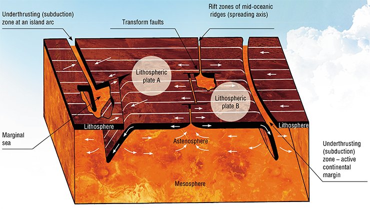
The data on the Earth’s structure obtained in the last century were of great significance for developing geology as a science. The recognition of the lithosphere which included the earth crust was the key point. The lithosphere is characterized by a high strength as opposed to the underlying asthenosphere, which contains the partially melted substance. The latter gives rise to convective flows. However, all possible faults, and accordingly, deep-seated and surface earthquakes, are recorded in the lithosphere.
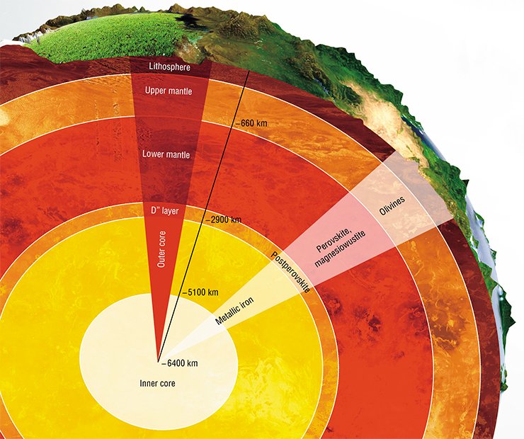
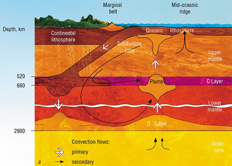
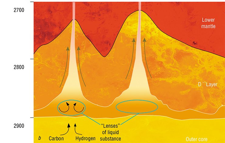
A relatively narrow (150—350 km thick) D`` layer, characterized by a sharp gradient of temperature (approximately from 4000° at the bottom to 3000° at the upper boundary) was discovered in the mantle bottom (inner layer) three decades ago. This layer is important, as separate pieces of the lithosphere sunk in the mantle reach this layer and it is from here that the deep-seated mantle substance begins rising towards the earth’s surface. Below we will discuss this in detail.
The important discoveries made in the second half of the last century have contributed to a better understanding of the Earth’s structure and evolution, and, what is the most important, gave rise to the plate tectonics concept. In 1961 English scientist Robert Dietz and American scientist G. Hess, analyzing the bathymetric map of the oceanic bottom, suggested that the mid-ocean ridges, which are 1 or 2 km higher than the abyssal valleys, are usually located in the central parts of the oceans. It is in particularly evident in the Atlantic Ocean, where a similar ridge is observed along an axial zone of the newly-formed crust of the oceanic bottom. The process of oceanic bed expansion was called “sea floor spreading”. A new crust is formed in the central (rift) structures of the mid-ocean ridges.
• The astenosphere substance is capable of buoyancy, which leads to convection sustained by the energy from the inner layers of the Earth.
• The lithosphere is the rigid outermost shell of the Earth that passively reacts to processes occurring in the underlying astenosphere. The lithosphere is cut by narrow deformation belts, i. e. zones demonstrating high tectonic (in particular, seismic) and magmatic activity: rift mid-oceanic ridges and subduction zones. These zones “break” the lithosphere into a number of rigid lithospheric plates, which move relatively to each other owing to ductile friction caused by convective (or any other) flows in the astenosphere
American scientists F. Vine and D. Mattews (1963) confirmed spreading by the presence of strip-like magnetic anomalies resulting from the magnetization of rocks of the oceanic crust following the recent polarity of the Earth’s magnetic field. The polarity alters in time from direct (recent polarity) into reversed.
In 1965 Canadian geophysicist G. Wilson recognized a specific type of faults – transform faults. They formed owing to the horizontal shifting of the oceanic lithosphere sideways from the mid-oceanic ridge. W. Morgan and a number of other researchers (1968) demonstrated significant difference between geophysical structures of the mid-oceanic ridges and island arcs zones. The latter demonstrate an underthrust – subsidence of the oceanic lithosphere into the mantle to a depth of about 600 km. This process was identified as subduction.
After the main principles of plate tectonics explaining the recent Earth’s dynamics had been formulated in 1968, this theory met the recognition from the majority of the scientific community. So, as soon as in 1971 more than one third of articles in geology published in Nature were devoted to this subject: the proposed concept gave an opportunity to explain most of recent endogenous processes. In a short time, the plate tectonics concept was applied to decoding the formation of the folded belts; moreover, many geologists considered that the new concept would enable them to solve the majority of the problems connected with the Earth’ s evolution.
Following hot spot track
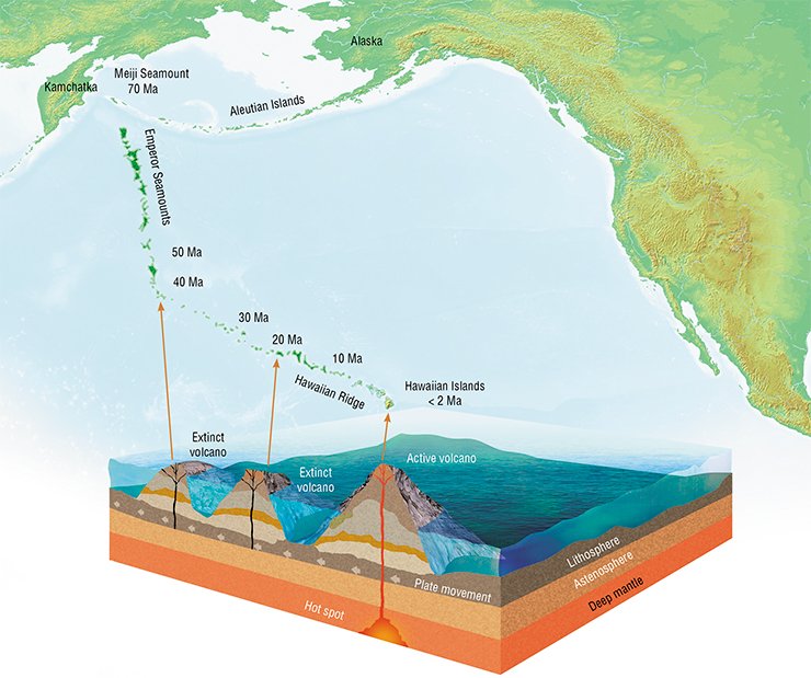
In 1963, when the first principles of plate tectonics were developed, G. Wilson (Wilson, 1963) turned attention to the active volcanoes that were located inside the oceanic slabs and formed the volcanic chains oriented in the direction opposite to the vector of oceanic slab shifting. It was suggested that the volcanic chains were related to the hot mantle spots, which burned through the lithosphere when it passed above them. The fundamental difference between the hot spots and lithosphere slabs is that the lithosphere slabs move along the asthenosphere and thus their geographical position at different times can change while hot spots hold their position for a long time with regard to the absolute geographic reference system identical to the modern one.
By the beginning of 1970s, the hot spots hypothesis was accepted by many researchers. The hot spots were considered to be geochemical anomalies, as magmatic rocks from such spots (compared with mid-oceanic-ridge basalts) were enriched with many trace elements. The defenders of this theory believed that the magmatic rocks generated by hot spots were related to “spots” of the warmed up asthenosphere which were immobile and fed on mantle plumes – flows rising from the lower mantle depth, most likely from the core – mantle boundary (CMB). The hot spot hypothesis suggested the existence of narrow (about 150 km in diameter) mantle flows (or columns) which penetrate all mantle layers, remaining immobile over a period of tens of millions of years.
A volcano is generated within the lithosphere plate located above a “spot” of the heated mantle. When the plate is shifted relative to the hot spot, a new volcano is formed above the hot spot. And as a result, the chain of lost volcanoes which mark the trace of the hot spot burned in the plate is generated.
An impressive example is the Hawaiian hot spot, related to which is the origin of the Hawaiian-Emperor ridge existent for about 100 myr. The reference position of this spot was used by many researchers to reconstruct the movements of the Pacific plate. It should be noted that reconstructions using the Hawaiian spot position completely coincide with the reconstruction of the Pacific plate drift restored by the strip magnetic anomalies.
However, a number of researchers such as Runcorn (Runcorn, 1980) indicated that geological and physical-chemical parameters of the mantle made the existence of plume columns improbable. The membrane tectonics conception (Turcotte, 1974) was put forward. According to it, when moving along the elliptic Earth’s surface rigid lithospheric plates pass through the sites with various curvature radiuses. As a result, deep cracks, filled later by the basaltic melt, appear in the plates. The peculiarities of the mantle melt composition were explained only by a different depth of the basalt melting. In this country such explanation of the hot spots was strongly supported by O. G. Sorokhtin (1979). However, all these hypotheses did not suggest the presence of some deep-seated structures that influence the geological processes of the upper Earth’s layers.
Pioneers of the hot fields
By 1980 it was found that the intraplate magmatic activity existed both in oceans (volcanic islands and plateau) and on continents, where it manifested through big geochemical differences between intraplate rocks and rocks associated with plate boundaries. For some hot spots intraplate magmatism (its composition, etc.) associated with these spots was investigated.
However, there were no studies devoted to the interaction of hot spots (as deep formations) and surface geological structures. In order to fill up this gap, a prominent Soviet geologist L. P. Zonenshain invited the author of this article М. I. Kuzmin to study this problem. The approach was remarkably straightforward: to find purely geographical regularities in the distribution of intraplate magmatic rock products on the Earth’s surface. Only quite young (0—15 myr) rocks and formations age were taken into account so that the possible drift of continents did not affect the reconstructions.
INTRAPLATE MAGMATISMIn the oceans intraplate magmatism mainly comprises basalts of oceanic plateaus and islands distinguished as a specific geochemical type of basalts – OIB (ocean island basalts). By composition, the basalts of trap provinces are similar to OIB, which is well exemplified by the Siberian trap.
Within the continents, the elemental composition of rocks from intraplate associations is diverse; however, the basalts of oceanic islands and intracontinental hot spots demonstrate a similar composition owing to their similarity with OIB
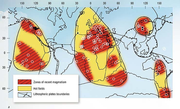
The obtained map of hot spot distribution indicated that there are four areas of recent intraplate magmatic activity: two big areas, the Pacific and the African, and two small areas, the Central-Asian and the Tasmanian. The largest amongst them (the African and the Pacific) are up to 10 000 km in diameter. Their size is comparable to the size of major lithospheric plates; however, the contours of the areas do not coincide with the boundaries of these plates.
The results were published in the article Intraplate magmatism and its significance for understanding processes in the Earth’s mantle (Zonenshain, Kuzmin, 1983), and the intraplate magmatism areas were called hot mantle fields. It was noticed that hot mantle field locations coincided with the big positive anomalies of the relief and positive deviations of geoid. Judging from the geochemical signatures of intraplate magmatic rocks, corresponding to these areas are the anomalies of material composition probably related to the lower mantle. This conclusion follows from the fact that the rocks formed in the oceanic rift zones (i. e. on plate margins) are the products of melting of the significantly depleted upper mantle, and thus demonstrate very low concentrations of all lithophile chemical elements.
Hence the recognized hot mantle fields can be regarded as areas where the substance and energy of the lower mantle rise to the surface of the planet, while cold mantle fields located in-between (related with the subduction zones of lithosphere plates) can be interpreted as zones where the substance sinks in the lower mantle. As a whole, those processes outline a consistent system of convective flows in the mantle.
If processes related to the upper layers could be described in terms of plate tectonics, the discovery of hot mantle fields meant that convection had a more deep-seated nature. So, the obtained results suggested an interaction between the lower and the upper mantle.
Narrow mantle flows associated with hot spots could be plumes uplifting from the lower-upper mantle boundary, wherethe heated substance of the lower mantle rises. They produce intraplate magmatism and an array of hot spots. The immobility of some hot spots relative to the lithospheric plates migrating over them results from the stable locations of hot fields lasting at least 150 myr (Geotectonics, 1983). These conclusions had been drawn before the development of seismotomography, which allowed geologists to gain insight into the inner structure of the mantle.
Unfortunately, these conclusions concerning the hot mantle fields remained unknown to the world geological community: an English version of the article,prepared during the oceanic expedition to Ceylon and sent by mail to the Earth Planetary Science Letters Journal, did not reach the addressee. There was no identical copy; moreover we started other studies. As the scientific community was not ready for this idea, we gave it up for a time.
Seismotomography as a key to understanding deep processes
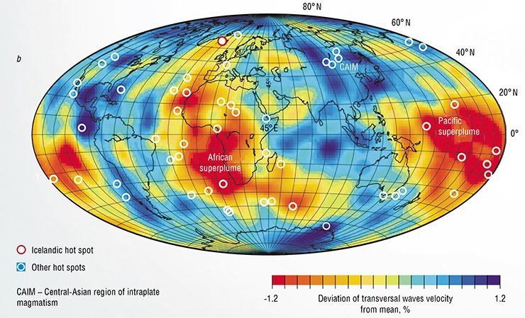
In the 1970s and 1980s thanks to the advance in computer science and increase in the number of seismological studies seismotomography developed fast. On the basis of the analysis of the seismic wave velocities, higher and lower shear velocity zones were recognized in the mantle.
There are two big lower shear velocity zones or provinces on the Earth: the African and the Pacific, presently also called –superplumes since seismotomography demonstrates that in these provinces a “lower velocity” substance from the mantle can be traced from D `` layer up to the upper mantle. It should be noted that projections of these mantle provinces on the Earth’s surface coincide with hot mantle fields recognized earlier.
By the 1990s L. P. Zonenshain understood that the geology as a science is on the way to a new deep geodynamics paradigm, describing the processes occurring in deep layers of the Earth. On October 25, 1991, just before having a major operation, he addressed in writing the 3rd International Conference on Plate Tectonics in Zvenigorod: “A new revolution is brewing, giving birth to a new science that could be called DEEP GEODYNAMICS. Plate tectonics is just one of its components. We mean the processes occurring in the lower mantle and at the core-mantle boundary (a great number of pioneer studies in this direction have been conducted in our country, and we must remember about it).”
On the same day Lev Pavlovich wrote to M. I. Kuzmin: “Would it be possible to develop this theory (deep geodynamics) in our country?” He considered that the following areas in geology should be developed: “(1) outer core – mantle interaction, (2) D `` layer and its geodynamics, (3) core – lower mantle – upper mantle exchange and substance flows, (4) deep-seated geochemistry and geochemical signature of the mantle, (5) historical geochemistry and historical geodynamics, starting from the Earth’s accretion up to the present. I omitted the internal core, we know almost nothing about it whereas the outer- inner core interaction may be the key point.”
At the end of the letter he wrote: “I am sure that the international scientific community will cope with these problems but we will not be involved. My big request to you is to act somehow so that my expectations (concerning our not involvement) are deceived.”
As opposed to them higher shear velocity zones, or provinces, are associated with cold areas which are characterized by the sinking of lithospheric plates in the mantle in the subduction zones. The subducted (absorbed) lithospheric material partially plunges into the upper-lower mantle boundary, while another part of the material goes down to the D `` layer at the core-mantle boundary (CMB). This process is responsible for the whole-mantle convection: the “cold” subducted substance plunges into the Earth’s mantle, while the compensating hot mantle uplifts to the surface as mantle plumes. Influenced by the energy from the core, the lithospheric substance plunged into D `` layer forms partially melted masses (Kearey et al., 2009), which give birth to the hot plumes uplifting to the Earth’s surface.
The hot mantle of superplumes in the form of a huge cloud rises through the lower mantle, breaking into a number of isolated plumes generating clusters of hot spots in the upper mantle in the lithosphere. The interaction of rising and descending flows in the mantle suggests a close association between the deep geodynamics processes, to which the mantle plumes correspond, and plate tectonics.
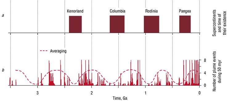
One of the most convincing arguments for plume and plate tectonics interaction is supercontinent and superplume evolution in uniform supercontinental cycles. It is well known that during the evolution of the Earth the supercontinents encompassed almost all continental masses of the Earth. Later these supercontinents were broken up by superplumes, and some continents began moving in different directions. Scientists believe that at least four supercontinents existed on our planet in different time periods (Kenorland, Colombia, Rodinia and Pangea), which were later broken by the underlying superplumes.
The supercontinent Rodinia formed nearly one billion years ago and began to break up about 250 million years later under the influence of underlying Rodinian superplume. Scientists believe that an antipodal plume located in the ocean existed simultaneously with the Rodinian one. After Rodinia’s breakup the constituent continents including Siberia could move into the corresponding areas of the Late Riphean Ocean.
A set of paleogeographic reconstructions was suggested in the paper published in the Earth Science Review (Kuzmin et al., 2010). The obtained results helped to shed light on a number of problems concerning the role of plumes and the role of hot mantle fields in the geological history of the Earth.
The Icelandic hot spot and drift of the Siberian continent
To understand the evolution of the Siberian continent in the Phanerozoic, the authors made some paleogeodynamic reconstructions. The paleomagnetic data are used to evaluate the palelatitude of geologic feature in the geological past while paleogeographic reconstructions are required to estimate the paleolongitude.
When interpreting the paleomagnetic data we concluded that after Rodinia’s breakup Siberia was extruded outside the supercontinent and came under the influence of the superplume that was antipodal to the Rodinian one. The Siberian continent was most likely associated with this particular superplume during most of the Phanerozoic. However, in order to make absolute (i.e. related to today’s geographic net) paleoreconstructions, we had to define the position of the projection of this superplume on the Earth’s surface, i.e. to define the position of the hot mantle field associated with this plume.
We chose the Icelandic hot spot occupying a stable geographic position for a long span of geologic time as a reference point to define the modern position of African LLSVP northern border. The track of this superplume observed in Siberia, Northern America and Northern Atlantic indicates that it has survived at least during 150 myr. In addition, a number of researchers believe that the superplume has existed 250 myrand was responsible for the origin of the Siberian trap. The Permian-Triassic paleolatitude for the Siberian trap location (62 ° ± 7 °) estimated using the paleomagnetic data almost matches the present day position of Icelandic hot spot (65 ° ±2°). Moreover, the element compositions of the West Siberian rift system basalts, Siberian trap, Arctic, East Greenland and Icelandic basalts (i.e. belonging to the Icelandic hot spot) indicate that they originate from the same mantle source. For instance, the Sr and Nd isotope ratio in these basalts of different age shows a uniform trend in the time range from 300 myr to the present time (Kuzmin et al., 2010).
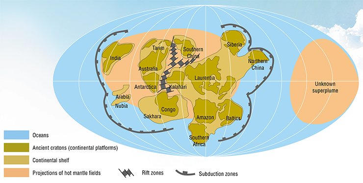
All these reconstructions show that the northern edge of the African hot field (superplume) located above the Icelandic hot spot existed 250 myr back. Some scientists suggest a longer survival of the African superplume (Torsvik et al., 2008) because the Skagerrak-centered LIP (North Sea), covering a huge area from England to Germany and Sweden, has been a stable source of magmatism for 300 myr. At that time its centre was located in the marginal part of the African hot field, namely near to its equatorial zone. According to these data, those contours of the African mantle province were similar to the modern ones.
Taking into account the longitudinal expansion of the African hot field and its long-term stable geographic position above the Icelandic hot spot for the last 250 myr, we assumed that the Siberian longitudinal displacements in the Phanerozoic were limited by this field. In this way, the paleolongitude position of the African superplume (between 10 W and 70 E) was used as a reference frame to define the Siberian paleolongitude. Moreover, its latitudinal displacements were significantly greater, which is confirmed by the data of many scientists summarized by V. A. Kravchinsky (Kuzmin et al., 2011 a). Based on these data we suggest a reconstruction of the Siberian drift from 570 myr back to the present.
Where did Siberia swim from?
There is much evidence indicating that Siberia moved above the mantle plumes starting from the Late Riphean (~600 Ma). The set of paleomagnetic data shows that OIB type rocks from the Dzhida ophiolite zone (Southern Buryatiya) were situated at 15—20 ° S. These results confirm that the Siberian continent was located in the African low shear velocity province (LLSVP) frame since 570 Ma.
The position of Siberia in the African LLSVP (about 30°S) during the Early Cambrian period is accepted following Pisarevsky et al., (1997) Starting from the Middle Cambrian, Siberia moved northward from 20 ° S in the southern hemisphere to near equatorial latitudes in the Early-Middle Ordovician. The velocity of the paleolatitudinal displacement from 512 to 480 Ma reaches 5 cm/year. Given possible longitudinal displacements the summary velocity should be higher. A speed of 5 cm/year is relatively high compared with today’s continental drift velocity; therefore, we suggest that the paleolongitude displacement should be minimal.
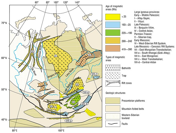
Another period of great intreplate magmatic activity in Siberia occurred from 320 to 190 Ma ago. A number of large igneous provinces formed at that time. One of them is the Barguzin that covers an area of over 2•105 sq. km and demonstrates a zonal structure: the margins includes rift zones, while the central part of the province is occupied by the largest Angara-Vitim granitoid batholith. It is considered that the anatexis of the continental crust and an intraplate heating led to the formation of the Barguzin province. It means that its central zone is an example of intraplate granitic rocks formed by the mantle plume.
The key magmatic event in the Late Paleozoic is the formation of the huge magmatic province uniting Siberian trap province and Western Siberian rift system. The traps erupted during a very narrow time interval (3 Ma). The volcanism is connected with grabens of the West-Siberian rift system which extend through West Siberia to the Arctic Ocean (over 1500 km).
Another large magmatic event occurred along the southern folded surrounding of the present day Siberian platform leading to the formation of Tarim trap and associated set of sub-parallel rifts in Mongolia (Gobi-Tien Shan and Mongolian lineament). Two other rift zones of the Central Asian rift system, Gobi-Altay and North Mongolian were formed as a result of the progressive propagation of the rift into the folded margin of the Siberian continent. The Khangai granitic batholith was formed simultaneously with the Gobi-Altay and North Mongolian rift systems and was located between them. The batholith was formed during an intraplate heating and an anatexis of the continental crust. The formation of the Central Asia rift system was completed in the Early Mesozoic by the origin of the zonal Mongol-Transbaikal magmatic area.
The intraplate magmatic activity throughout northern Asia decayed abruptly at ~ 190 Ma ago and the Late-Paleozoic-Early Mesozoic stage of magmatism terminated. The influence of mantle plumes on the Siberian paleocontinent recommenced in the Late Mesozoic leading to the formation of a number of rifts in the Central-Asian surrounding of the Siberian platform. The peak of magmatism corresponded to the beginning of the Cretaceous era. Only meager magmatic activity took place during the next stage: small lava fields and shield volcanoes were formed.
New intraplate volcanic activity occurred in the Central and Eastern Asia during the Late Cenozoic stage (< 25 Ma). Novel hot spots were responsible for the formation of new large volcanic areas (e. g. South Baikal)
The reconstructions of the Siberian drift in the Permian-Triassic were based on the hot spots (Altay-Sayan, Viluy, Barguzin (Siberian trap) and Mongolian) that operated during this time interval. These reconstructions showed that an average latitudinal velocity of the Siberian movement northward amounted to about 7 cm/year assuming that the longitudinal position of Siberia was fixed.
The first sign of the mantle plume action near the Siberian continent was observed in the Altay-Sayan area in the Ordovician (Dobretsov, 2011). Later, in the Early Devonian, when Altay-Sayan accreted to Siberia, this plume (located as 40±15° N: 0 ° E) gave rise to a triple-junction graben system of the Altay-Sayan Rift Area. By the Middle Devonian, Siberia rotated and overlapped the Vilyui hot spot (35 ± 15° N and about 20° W), at the same time holding its position above the Altay-Sayan hot spot. The impact of this hot spot on the lithosphere resulted in the origin of the grabens of the Viluy Rift System and breakup of the continent in the eastern part. After the continent moved away from those hot spots, their tracks were lost. The Icelandic and Mongolian hot spots responsible for a number of magmatic events in the Central Asia had a longer influence on the Siberian continent.
Paleomagnetic data show that in the Early Carboniferous Siberia had to displace from ~ 30° to ~ 60 ° N during 40 Myr, i.e. an average velocity amounted to ~ 11 cm/yr. Such high velocity suggests that the continent moved along the meridian only, i.e. the drift of the continent in the direction parallel to the equator was almost absent. The displacement of Siberia towards the north led to collisions with a number of small terranes, volcanic arcs and islands overlapping the Icelandic hot spot (Kuzmin et al., 2010) and to the formation of the Barguzin-Vitim magmatic area with the Angaro-Vitim batholith in the center of the area and rifting structures framing the batholith. This specific form of the plume activity was defined by the peculiar properties of plume in the subduction environment of the active continental margin which led to an enormous anatexis of the continental crust.
During the Permian period (from 280 to 250 Ma), the Siberian Continent continued a clockwise rotation that led to migration of magmatism associated with the Icelandic hot spot from the Barguzin-Vitim area to the Siberian trap province. The trace of the hot spot can be monitored by paleomagnetic data, in particular, remagnetization of palaeotypal rocks from the base metal ore deposit Ozernoe and Sukhoy Log gold ore deposit (Kuzmin et al., 2010) into Permian-Triassic orientation.
Another large magmatic event that occurred simultaneously with the Barguzin-Vitim magmatism led to the formation of the Gobi-Tien Shan rift zone, Main Mongolian lineament (310—285 Ma) and Tarim trap. Their formation enables us to propose the existence of another Mongolian (or Tarim) hot spot during the same time. The continued displacement and clockwise rotation of Siberia in the Permian and Early Mesozoic led to the migration of magmatism above the Mongolian hot spot into the Transbaikalia. This migration resulted in the formation of the Khangai and East-Mongolian-Transbaikalian magmatic areas similar to the Barguzin with respect to their structures.
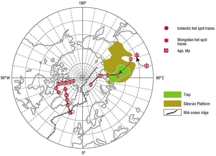
In the Mesozoic Siberia moved away from the Icelandic hot spot, and this displacement revealed itself through a number of magmatic events that occurred during the Mesozoic in the Arctic basin. Our reconstructions show the departure of Siberia from the African hot field at that time. It was concluded that the intraplate magmatic activity within the Siberian continent came to an end in the time interval from 190 to 160 Ma.
In the Late Mesozoic-Early Cenozoic, the intraplate magmatic activity appeared again in the southern framing of the Siberian platform. This activity was related to the existence of an array of long-living mantle hot spots that have held their stable geographical positions over 140 myr. These hot spots gravitated toward a set of mantle plumes recognized by Zhao (Zhao, 2009) within the southwest margin of the Pacific Ocean which, in all probability, is one of the branches of the Pacific superplume. Therefore we believe that by the beginning of the Late Mesozoic Siberia had significantly drifted eastward and thus arrived in the Pacific plume influence zone. Such a quick latitudinal drift of the Siberian continent must have resulted from the opening of the Atlantic and Indian Oceans.
Summarizing the above-said, we can state that the Earth is a self-organizing system, whose development is associated with the interaction of internal layers. This interaction is recognized through convection of various types.
Convection in the upper mantle can put in motion lithospheric plates. In its turn, this convection is governed by a more deep-seated convection in subduction zones: on the one hand, subducting “cold” lithospheric slabs can sink in the lowermost mantle up to the CMB (core-mantle boundary) thus provoking a counter flow of hotter mantle rising to the Earth’s surface; on the other hand, exchange processes on the CMB lead to a high heating of the mantle and probably to its melting in D `` layer. Such an overheated and less dense mantle becomes buoyant and uplifts, stimulating the whole mantle convection.
As opposed to descending flows of subducting slabs, having the geometry of big plates with large linear dimensions, the hot mantle uplifts to the Earth’s surface as separate flows or mantle plumes. It has been established that such uplifting mantle flows are mainly concentrated in two sectors on the Earth which are recognized as superplumes: Pacific and African. The lower mantle of these superplumes is characterized by an increased temperature, and the seismotomography demonstrates lower velocities of seismic waves, i.e. large low shear velocity zones or provinces (LLSVP) are recognized.
The role of such superplumes for the Earth’s lithosphere formation can hardly be overestimated. However, the following questions arise: Where and why do the superplumes originate? How long do they exist? and How stable is their influence on the lithosphere?
The reconstructions made by the authors have contributed to the resolving of the above problems. First of all, we proposed that intraplate magmatism on the Siberian continent was a result of its drifting above the cluster of hot spots in the African LLSVP during most of the Phanerozoic eon. The long-term intraplate magmatic activity within this superplume suggests that the age of this superplume is similar to that of the antipodal plume that led to the breakup of Rodinia. Hence, this superplume survived at least 1 Ga. Taking into account that the Rodinian superplume is compared with the Pacific in terms of their location, both superplumes can be regarded as the most long-lived deep-seated structures of the Earth.
The fact that superplumes are connected with the formation and breakup of supercontinents is now universally recognized. Recent results suggest that fragments of supercontinents, after their breakup by the superplume-murderer, shift to the areas of the Earth controlled by the antipodal superplume and form a new supercontinental agglomeration above it. Such participation of superplumes in the formation and the subsequent breakup of supercontinents, apparently reflects their antiphase activity, possibly connected with the corresponding convection, one of the reasons for which could be the thermostatting effect (Kovalenko et. al., 2010).
Finally, we should make a forecast conclusion. When the supercontinents formed, in particular Pangea, separate continents moved above the superplume hot spots of different age and preserved their traces in the structure. This fact allows suggesting that in the nearest future the available methods of studying of magmatic rocks will allow to estimate the evolution of their mantle sources both for separate plumes and for superplumes as a whole. IUltimately, this will contribute to a better understanding of the general laws in the evolution of the Earth.
References
Ajzeks B., Oliver Dzh., Sajks L. Sejsmologija i novaja global’naja tektonika // Novaja global’naja tektonika. M.: Mir, 1974. S. 133—179.
Dobrecov N. L., Kirdjashkin A. G., Kirdjashkin A. A. Glubinnaja geodinamika. Novosibirsk: Izd-vo SO RAN; filial «Geo», 2001. 407 s.
Dobrecov N. L., Borisenko A. S., Izoh A. Je., Zhmodik S. M. Geodinamicheskaja model’ permotriasovyh mantijnyh pljumov Evrazii kak osnova prognoza rudnyh mestorozhdenij // Geologija i geofizika. 2010. T. 51, № 9. S. 1159—1187.
Zonenshajn L. P., Kuz’min M. I. Vnutriplitovyj vulkanizm i ego znachenie dlja ponimanija processov v mantii Zemli // Geotektonika. 1983. № 1. S. 28—45.
Zonenshajn L. P., Kuz’min M. I. Paleogeodinamika. M.: Nauka, 1992. 192 s.
Zonenshajn L. R., Kuz’min M. I., Natapov L. M. Tektonika litosfernyh plit territorii SSSR: v 2 kn. M.: Nedra, 1990. Kn. 1. 326 s. Kn. 2. 334 s.
Izmenenie okruzhajushhej sredy i klimata: prirodnye i svjazannye s nimi tehnogennye katastrofy (otv. red. V. I. Kovalenko, V. V. Jarmoljuk, O. A. Bogatikov).
T. 2: Novejshij vulkanizm Severnoj Evrazii: zakonomernosti razvitija, vulkanicheskaja opasnost’, svjaz’ s glubinnymi processami i izmenenijami prirodnoj sredy i klimata. IGEM RAN, IFZ RAN, 2008. 430 s.
Kuz’min M. I., Jarmoljuk V. V., Kravchinskij V. A. Absoljut¬nye paleogeograficheskie rekonstrukcii Sibirskogo kontinenta v fanerozoe: k probleme ocenki vremeni ¬sushhestvovanija superpljumov // Dokl. Akad. nauk, 2011 a. T. 437. № 1. S. 68—73.
Kuz’min M. I., Jarmoljuk V. V., Kravchinskij V. A. Fanerozojskij vnutriplitnyj magmatizm Severnoj Azii: absoljutnye paleogeograficheskie rekonstrukcii afrikanskoj nizkoskorostnoj mantijnoj provincii // Geotektonika. 2011 b. T. 45, № 6. S. 3—23.
Hain V. E. Osnovnye problemy sovremennoj geologii. M.: Nauchnyj mir, 2003. 348 s.
Harin G. S. Impul’sy magmatizma Islandskogo pljuma // Petrologija. 2000. T. 8, № 2. S. 115—130.
Condie K. C. Mantle Plumes and their Record in Earth History. Cambridge University Press. 2001. 305 p.
Kovalenko V. I., Yarmolyuk V. V., Bogatikov O. A. Modern Volcanism in the Earth’s Northern Hemisphere and Its Relations with the Evolution of the North Pangaea Modern Supercontinent and with the Spatial Distribution of Hotspots on the Earth: The Hypothesis of Relations between Mantle Plumes and Deep Subduction // Petrology. 2010. Vol. 18. No. 7. P. 657—676.
Kuzmin M. I., Yarmolyuk V. V., Kravchinsky V. A. Phanerozoic hot spot traces and paleogeographic reconstructions of the Siberian continent based on interaction with the African large low shear velocity province// Earth-Science Review. 2010. Vol. 102. No. 1—2. P. 29—59.
Li Z. X., Zhong S. Supercontinent-superplume coupling, true polar wander and plume mobility: plate dominance in whole-mantle tectonics // Physics of the Earth and Planetary Interiors. 2009. 176. P. 143—156.
Maruyama S., Santosh M., Zhao D. Superplume, supercontinent, and postperovskite: mantle dynamics and anti-plate tectonics on the core-mantle boundary // Gondwana Research. 2007. 11 (1—2). P. 7—37.
Morgan W. J. Deep mantle convection plumes and plate motions//Bull. Am. Assoc. Petroleum Geols. 1972. Vol. 56. P. 203—213.
Yuen D. A., Maruyama S. H., Karato S.-I., Windley B. F. Superplumes: Beyond Plate Tectonics. Springer, 2007. 569 p.
The autors thank Dr. Vadim Kravchinsky, who supplied explanations of absolute reconstructions of the Siberian continent without which it would have been impossible to obtain the scientific results presented here


