What Natural Disasters Are and How We Can Fight Them
Natural disasters are a source of profound social perturbations leading to mass suffering, loss of life and enormous material damage. Underlying an increase in the number of natural disasters are global processes such as economic and population growth of the earth’s civilization, degrading environment and climatic change. Fighting natural disasters is a key element of the state policy aimed at sustainable development. Rational economic use of territories, forecast of impending hazards and preventive measures should become the key principles of the state policy
 appeared on October 14, 1968 as a result of an earthquake accompanied by surface waves. Aerial photo by B. Bolt (California University archive, Berkley)") Since the ancient times, man has been fearful of powerful natural phenomena. The history of our civilization illustrates how natural disasters may lead to large-scale social upheavals. The destruction of Pompeii in Italy as a consequence of Vesuvius eruption (79 B.C.) is just one of the many examples of how prosperous cities can go into decline as a result of natural disasters and then disappear completely. There have been cases when economic losses from natural disasters exceeded the national GNP, which resulted in a critical situation. For example, direct damage from the 1972 earthquake in Managua equaled two annual GNPs of Nicaragua.
Since the ancient times, man has been fearful of powerful natural phenomena. The history of our civilization illustrates how natural disasters may lead to large-scale social upheavals. The destruction of Pompeii in Italy as a consequence of Vesuvius eruption (79 B.C.) is just one of the many examples of how prosperous cities can go into decline as a result of natural disasters and then disappear completely. There have been cases when economic losses from natural disasters exceeded the national GNP, which resulted in a critical situation. For example, direct damage from the 1972 earthquake in Managua equaled two annual GNPs of Nicaragua.
Analysis of historical data indicates a steady growth of natural disasters: over the last fifty years, the frequency of large-scale catastrophes has grown five times, and the material damage caused by them has increased tenfold. Sometimes, the economic losses were as high as 190 billion dollars. With the existing level of protection, by 2050 economic and social damage from hazardous natural processes is expected to reach almost half of the Gross Global Product growth. The average damage from natural and technological disasters in Russia currently accounts for about 3 % of its GDP.
In the context of global safety, disasters are considered to be among the most significant destabilizing factors preventing sustainable development.
In fact, what is a “natural disaster”? What mechanisms underlie their birth and development? Can their destructive consequences be avoided? And why, despite the continuous scientific and technical progress, does the humanity feel unprotected?
Disastrous energy
According to the opinion of the outstanding Soviet natural scientist V. I. Vernadsky, the earth surface layer is more than a domain of matter, it should be treated as a domain of both matter and energy.
Actually, the earth’s surface and adjacent atmosphere is where numerous complex processes occur, accompanied by energy transformations. Among them, there are endogenic processes, referring to matter transformations inside the earth, and exogenic interaction of the matter of the earth’s outer layer with energy fields and solar radiation.
All these processes drive the continuous transformation of global geodynamics and cause hazardous events on the earth’s surface and in its atmosphere such as earthquakes, volcanic eruptions, tsunamis, floods, tornados, and so on.
It is customary to classify natural disasters depending on the medium affected by energy: the earth’s crust, air or water.
Earthquakes seem to be the most frightful of all natural disasters. Powerful shock waves generated by subterranean processes result in ground fractures, causing dreadful deterioration of human habitat. The released energy sometimes exceeds 1018 J, which is equivalent to the explosion of hundreds of atomic bombs like the one dropped on Hiroshima in 1945.
. Aerial view of the leaning houses produced by soil liquefaction and poor foundations. National Geophysical Data Centre")
China, where earthquakes occur almost every year, suffers the most. For example, back in 1556 the death toll after a series of powerful earthquakes reached 0.8 million (about 1% of the country’s population). Over the last decade alone, about 80,000 Chinese perished in earthquakes; the economy suffered losses exceeding 1.4 trillion yuans.
In Russia, the most destructive of recent earthquakes occurred in the north of Sakhalin, in May 1995. It totally demolished the settlement of Neftegorsk and killed over 2,000 people.
However, the most powerful sources of energy on the planet are volcanoes. The energy released as a result of a volcanic eruption can exceed the “contribution” of the most powerful earthquake a hundred times. Annually, volcanoes eject to the atmosphere and to the earth’s surface about 1.5 billion tons of hypogenic substances.
Presently, the Earth has approximately 550 historically active volcanoes (every eighth of them in Russia). During the historical time, volcanic activity has killed at least a million people.
The colossal eruption of the Krakatoa volcano in the Southeast Asia occurred at the end of the 19th century. The volcano ejected millions of cubic meters of volcanic ash to a height of 80 kilometres and produced a “polar night” with the earth sunk in semi-darkness for several months. Direct solar beams did not reach the earth’s surface so it became much colder. What happened was later compared with a “nuclear winter,” potential consequences of an explosion of a super powerful nuclear bomb on the earth’s surface.
 after the earthquake on 29th April, 1965. University of California Archive (Berkley)")
In the spring last year, the world lived through a new natural disaster, a volcano eruption in Iceland, which inflicted considerable losses on the economies of many countries (especially in Europe).
In the 1980s, two earthquakes of similar magnitude in Spitak (Armenia) and San-Francisco (California, USA) had very different consequences. The former killed about 40,000 people, the latter only 40 (!). The difference was due to the quality of the building structures used and organisation of preventive measuresEarthquakes and volcano eruptions occurring in water often give rise to a tsunami. A wave forming in the open ocean during a volcanic explosion or shock can gain horrendous destructive power when reaching the shore. The Biblical Flood and the Atlantis demise are ascribed to a volcanic eruption in the Mediterranean, accompanied by a tsunami.
In the 20th century, more than two hundred tsunamis were recorded in the Pacific Ocean alone. In December 2004, a series of enormous waves brought on the north-eastern coast of the Indian Ocean claimed the lives of more than 200,000 people and caused the economic damage of 10 billion dollars.
. Right: the ancient print shows the eruption of Nea Kameni volcano on Santorini Island in the Aegan Sea in 1866. You can see a caldera sunk in the water. The most catastrophic eruption on the island took place in 1650 B.C., causing the destruction of the Minoan civilization and the creation of a legend about the demise of Atlantis. Photo by P. Hedervari (National Geophysical Data Centre)")
The Biblical legend of the Flood may also come to the mind of the people living in the countries which often find themselves in the grip of massive floods – inundation of vast territories resulting from sharp rises in the river, lake and other water reservoir levels. The floods are dangerous by themselves; also, they provoke a great number of other natural disasters such as landslides, landslips and mud flows.
One of the most terrifying floods occurred in China in 1887, when the waters of the Huang Ho River rose to the height of an 8-story building within a few hours. As a result, about 1 million people living in this river valley died.
According to UNESCO data, 4 million people died last century as a result of floods. One of the latest destructive floods occurred in summer 2002 in the Czech Republic. The water flooded the streets of hundreds of settlements and cities, including Prague, where 17 metro stations were under water.
, 2007")
Such large-scale natural disasters occur in Russia as well. During the spring flood of 1994 on the Tobol River, the water flowed over the protective dam in Kurgan, leaving thousands of houses flooded to the top for two weeks. Seven years later, an even more destructive flood occurred on the Lena River in Yakutia.
Finally, we cannot but mention the air element with its cyclones, storms, tornados and hurricanes. On average, approximately 80 disastrous natural hazards connected with these phenomena occur on the globe annually. Oceanic coasts often suffer from tropical cyclones ravaging the continents, with hurricane air currents rushing at a speed of 350 km/h, torrential rains producing up to 1000 mm of precipitation in several days and stormy waves reaching the height of up to 8 m.

In the autumn of 2005, three large destructive hurricanes caused the American continent a 156 billion dollar damage. Compared with them, the hurricanes that were ravaging Western and Northern Europe at the turn of the millennium look more modest as the damage caused by them was one-tenth of the year 2005 hurricanes.
The ubiquitous humankind
The main reason for more deaths and material losses brought about by natural disasters is the uncontrollable growth of human population.
In the ancient times the human population changed insignificantly. The periods of growth took turns with those of decline as the result of an increased death rate from epidemics and famine. Until the 19th century the human population did not go beyond 1 billion. However, with the onset of the industrial era, the situation has changed dramatically: in 100 years the population doubled and by 1975 was over 4 billion.
Population growth is accompanied by urbanization. The city population, which accounted for a little more than 3 % in 1850, has now grown to at least 50 % with the average growth rate higher (4 % per annum) than that of the human population in general (1.7 % per annum).
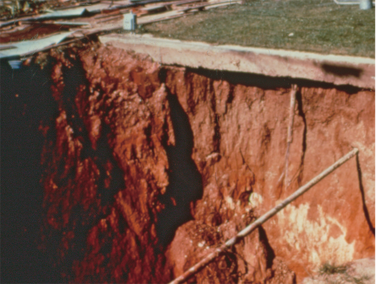
. This is a view on a techno-natural disaster: land subsidence (bottom) caused by the collapse of a coal mine near city of Lafayette (Colorado, USA).Photo by B. Bradley (University of Colorado, USA)")
The growth of the earth population leads to the development of lands that are not really suitable for habitation, such as hillsides, flood plains and swampy lands. Things get even worse as these areas often lack proper infrastructure and the new buildings often lack proper design. As a result, cities more often find themselves in an epicenter of destructive natural disasters, where human sufferings and deaths snowball to a mass scale.
Industrial and technological revolution has led to the global intervention of man in the lithosphere, the most conservative part of the environment. As early as 1925, V. I. Vernadsky noted that man’s scientific thought creates “a new geological force.” Nowadays, by the scale of geological activities people have become comparable to nature. During construction works and extraction of mineral resources over 100 billion tons of rocks is relocated every year, four times more than the amount of land erosion products washed away by all the world’s rivers together.
The technogenic intervention in the lithosphere is a key factor of environmental changes. It activates natural processes and gives rise to the development of new, techno-natural processes. These new processes include subsidence of tracts as a result of mineral extraction at large depths, induced seismicity, underflooding, caving and piping, formation of different physical fields, etc.
 in 2000")
Thus, two opposing tendencies are developing in the modern economy: global gross income is increasing while the life-supporting resources of “natural capital” (water, soil, biomass, ozone layer) are degrading. This happens because industrial development, whose primary goal is to facilitate economic progress, is now more tended to disregard the limitations imposed by biosphere sustainability and, for this reason, comes into conflict with the natural environment.
An increase in the frequency and scale of floods is due to deforestation, drying-out of wetlands, and soil compaction. Such “land improvement” results in an accelerated surface runoff from the basin into the river bed and a sharp rise of the water level in the conditions of extremely heavy precipitation or snow melting.
In a real sizzler?
Many people now express concern for the future. According to the Biblical revelations, the human civilization will be killed by fire. Global climate changes over the last 150 years suggest that our travel towards the “end of the world” has already begun.

According to the World Meteorological Organization, the global temperature has grown by about 0.8°C. Regional observations suggest sharper changes. For example, in the northern regions of Russia, average long-term temperature has grown by 1.0°C over the last 30 years, about 2.5 times of the global temperature trend dynamics. The accelerated temperature growth is primarily due to the increase of average winter temperatures, whereas summer temperatures could have even somewhat declined.
Over the last decade, some regions of the world suffered from anomalous summer heat. In August 2003, the temperatures in some countries of Western Europe went up to +40°C, causing the death of more than 70,000 people from heat stroke.
, which arrived at the Hawaii, totalled 26 million dollars. In Hilo, all the houses facing the bay were washed away, the railroads were ruined and the coastal roads were destroyed. An archive photo of U.S. engineering troops. Right: A ship turned upside down by a tsunami on the coast of the Resurrection Bay, 75 km away from the epicenter of the earthquake that gave birth to giant waves. Alaska, 1964. An archive photo of the U.S. Department of the Interior")
Despite a controversy over the causes of global climate change, the fact that the earth has become a warmer place is incontestable. Further increase of the air temperature may have both a positive and negative effect on the natural environment resulting in desertification, inundation, sea coast destruction, glacier sliding, permafrost retreat, etc.
The shortage of drinking water presents now a severe humanitarian problem. In recent years, disastrous droughts have taken place in Latin America, North Africa, India and Pakistan. In the nearest future, the area of the land gripped by droughts is expected to increase significantly. The number of “ecological refugees” keeps growing very quickly.
 temperature of ground air from the benchmark level of 1962 varies but the trend line (floating average for 20-year periods) definitely has an upward direction. According to the Climatic Research Unit (Great Britain, 2008)")
Melting of the Greenland ice cap and high-mountain glaciers presents one of the most serious hazards associated with global warming. According to the satellite observations, since 1978 the Antarctic ice cap has been diminishing by 0.27 % annually in terms of the area, also losing in the ice field thickness.
As a result of glacier melting and thermal expansion of water, the level of the world ocean has risen by 17 cm over the last 100 years. The ocean level is expected to rise 5–10 times quicker in the near future, which will require considerable investments in the rescue operations on the coastal lowland territories. The world ocean rise by half a meter would cost the Netherlands about 3 trillion Euros to fight the inundation and the Maldives, 13,000 dollars per running meter of the coast to be rescued from the sea.
. Many territories on the Yamal Peninsula are affected by the thermokarst processes: they are practically devoid of vegetation (right). TheYuribey River valley")
Warming will be accompanied by degradation of permafrost rocks in the cryolite zone, which constitutes a considerable part of our country’s territory. It has been observed that over the last century the permafrost soil area in the northern hemisphere diminished by 7 % and the average depth of permafrost penetration, by 35 cm. If the current climatic tendency persists, in the next decade the continuous permafrost line will shift 50–80 km to the north (Osipov, 2001).
The cryolite zone degradation will trigger such dangerous processes such as thermokarst, sinking of an area as a result of ground ice melting and ice crust formation. Undoubtedly, this will exacerbate safety problems faced by the gas and oil industries developing mineral resources in the north.
Natural disasters prevention
Until recently, the efforts of many countries in “mitigating the risks” of natural disasters have been confined to eliminating their consequences, helping the victims, providing technical and medical services, food supply and so on. However, a persisting tendency towards the growth of the frequency of disastrous events and the scale of their aftermath makes the governments’ efforts less and less effective.
When developing the concept of “fighting natural disasters” it is important to understand that man cannot stop or change the course of evolutionary transformations on the planet; he can only predict their development, to a certain degree, and sometimes influence their dynamics. For this reason, nowadays the scientists are setting up new priorities: prevention of natural disasters and mitigation of their negative consequences.
: 1 – insular (< 50% of the area with permafrost soils); 2 – non-continuous (50–90%); 3 – continuous (>90%); 4 – seasonal freezing. Almost one fourth of the territory of Russia is located in the permafrost zone. Global warming causes the destruction of permafrost soils and land subsidence as a result of thermokarst processes")
The strategy of fighting the elements is based on the assessment of risks, i. e. the probability of disastrous events and expected human victims and material losses.
The impact of natural hazards on humans and infrastructure is expressed as the vulnerability index. For people, it reflects a reduction in the ability to perform their functions as a consequence of death, loss of health or severe injury. For technosphere, it shows the destruction, damage or partial damage of the objects.
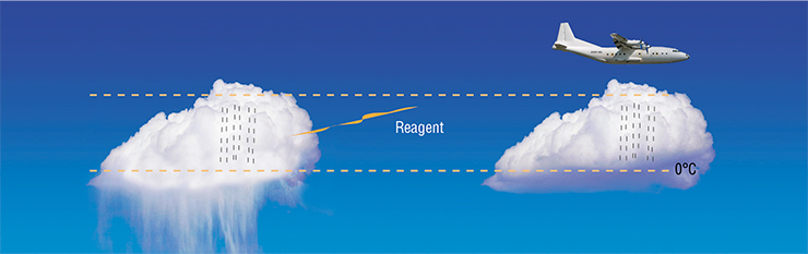
Controlling the development of the majority of natural hazards is a rather complicated task. Many natural phenomena such as earthquakes and volcano eruptions are beyond any direct control. However, humans have accumulated many years’ positive experience in influencing natural processes, in particular some hydrometeorological phenomena.
For example, the research institutions of the Russian Hydrometeorological Service have developed the technologies of spraying active reagents in the cloud fields using rockets, aircraft and land equipment in order to increase and redistribute rainfall, to dispel fogs in the vicinity of airports, and to prevent hail damage to crops. It has also become possible to control precipitation during man-caused disasters. In 1986, they have managed to prevent river basin contamination by the fallout resulting from the explosion at the Chernobyl nuclear power station.
, Science V. 315, p. 368")
It is common practice, however, to act indirectly by enhancing the sustainability and protection of both people and infrastructure against natural hazards. The priorities are vulnerability reduction measures such as rational land management, rigorous engineering support at the construction of infrastructural objects and protection of adjacent territories, development of preventive and emergency response means.
Within an apparently homogeneous territory, plots of land with different geomorphological, hydrogeological, landscape and other conditions respond to natural impact differently. In the lowlands with weak saturated soils, the intensity of seismic waves can be several times higher than in a neighbouring tract composed of rocks.
Evidently, the vulnerability and safety issues should be addressed based on a justified and responsible choice of land plots for the construction of settlements, industrial and civic objects, and the units of life-supporting systems. This is the primary goal of engineering geological zoning. It is carried out to identify the tracts with identical or similar geological properties and to rank them by suitability for economic development and resistance to natural and man-caused hazards.
For earthquake-prone areas, a map of seismic microzonation is drawn, too. Intended for ranking the zones by the level of seismic hazard (intensity), it takes into account all factors influencing the spread of elastic waves in the geological medium. As an example, the Imereti lowland in the Adler district, where the construction of a complex of buildings for the 2014 Olympic Games is currently underway, has been zoned, with the participation of the E. M. Sergeev Institute of Geoecology, RAS.

Risk assessment is made based on the probability of occurrence of a natural hazard, its physical parameters and the place and time of its occurrence.
If a natural hazard occurs in urban or economically developed areas and directly affects people and material objects, risk realization includes all the ensuing consequences.
Vulnerability characterises the inability of people or elements of social and material spheres to withstand natural hazards and is expressed in relative units or per cent.
The procedure of risk analysis is calculating the expected loss at the occurrence of a natural hazard based on its quantitative assessment and determining the vulnerability of risk recipients (people and objects).
When the calculated risk is unacceptable (acceptance criteria are so far too subjective), risk management or risk-lowering measures are implemented. Some of them are targeted directly at natural hazard development; the others have to lower the vulnerability of the technosphere and increase people’s safety
It is often necessary to use the land which is known to be unsuitable for construction, namely sections on the sea coasts and in river valleys, mountain hillsides, and plots with karstified and sagging soils. In this case, preventive engineering activities are carried out to increase the land stability and protect the buildings: erection of solid walls and dams, construction of drainage systems and spillway works, elevation of land plots by soil deposition, strengthening of soil by compaction, cementation and reinforcement.
Erection of a protective dam which has blocked a section of the Gulf of Finland and the Neva river mouth is just one example of recent large-scale protective hydrotechnical construction. Such a facility was in high demand because almost annually, due to the backing up by the wind from the Baltic Sea, the water in the Neva River rose by more than 1.5 m, the level used as a reference point when Saint-Petersburg was designed. The dam completed in 2009 can withstand a rise of water by more than 4 m, which removes the threat of flood for the city residents.
, where the construction of a complex of buildings for the Olympic Games is underway, was zoned in terms of the level of seismic hazard")
However, protection of an area and even a rational choice of construction sites do not suffice for safety. When a natural disaster happens, people are most often killed by collapsing residential and industrial buildings. For this reason, it is necessary to improve the design solutions, use stronger materials, monitor the condition of the buildings and facilities already constructed, and periodically strengthen their structural parts.
Successful natural safety management is useless if lacking a warning and emergency response system, which includes the means of observation to monitor hazardous processes (monitoring tools), on-line data transfer and processing, and warning the population about incipient danger.
Monitoring is a key element of the forecasting and prevention system. Prognostic monitoring is the observation of anomalous natural phenomena or changes of the geoindicators reflecting their development. Long-term prognostic monitoring makes it possible to develop databases and time series of observations. Their analysis can help to identify the persisting trends in the dynamics of a hazardous process, model causal effects and predict emergency situations.
To mitigate the consequences of “flash” disasters (for example, earthquakes), where reliable forecasting is lacking, the so-called security monitoring can be used. It is tuned to the extreme phase of a disaster and allows taking automatic emergency measures for minimizing the consequences of the disaster just seconds before the critical moment occurs and without human interference.
A security monitoring system in most cases cuts off the power supply systems (gas, electricity), warns the personnel, etc. Protective systems are implemented at high-responsibility and high-risk facilities, first of all at nuclear power stations, oil processing plants, oil sea platforms, pump stations of chemical product pipelines, and so on.
A seismic safety system using strong-motion accelerometers (measuring acceleration forces) can serve as an example of protective monitoring. The system has been developed at the E. M. Sergeev Institute of Geoecology (RAS) and implemented on the Sakhalin offshore oil platforms. A special algorithm for the analysis of sensor records is used to discriminate the object displacements due to seismic and other causes. Thereby the system sends a warning signal only when the recorded intensity exceeds a preset threshold value and ignores other shocks, which precludes a false alarm.

In recent decades, some dangerous tendencies have surfaced in the development of natural processes, which are largely caused by the population and economy growth. The irreversible growth in the number of disastrous events, including techno-natural disasters, brings the natural risks assessment and fighting methods to the forefront of the state policy.
Effective risk management is based on the modern level of knowledge about natural phenomena, systematic monitoring of hazardous processes, adequate culture of economic activities and responsible managerial decisions at different levels of power. The strategy of risk management should be an integral part of any project or investment program related to construction, education, welfare and health.
After mankind’s breakthrough into space we have to look back at Planet Earth, our common home. The problems of planetary scale should find their place next to the fundamental and practical tasks because the solution of these problems is critical to the future of our civilization.
References
Global’naja jekologicheskaja perspektiva (Geo-3): proshloe, nastojashhee i perspektivy na budushhee / Red. G. N. Golubev. M.: JuNEPKOM, 2002. 504 s.
Osipov V. I. Prirodnye katastrofy na rubezhe XXI veka // Vestnik RAN. 2001. T. 71, № 4. S. 291–302.
Prirodnye opasnosti Rossii: v 6-ti t. / Pod obshh. red. V. I.Osipova, S. Shojgu. M.: Izdatel’skaja firma KRUK, 2000–2003: Prirodnye opasnosti i obshhestvo / Pod red. V. A. Vladimirova, Ju. L. Vorob’eva, V. I. Osipova. 2002. 248 s.; Sejsmicheskie opasnosti / Pod red. G. A. Soboleva. 2001. 295 s.; Jekzogennye geologicheskie opasnosti / Pod red. V. M. Kutepova, A. I. Sheko. 2002. 348 s. ; Geokriologicheskie opasnosti / Pod red. L. S. Garagulja, Je. D. Ershova. 2000. 316 s.; Gidrometeorologicheskie opasnosti / Pod red. G. S. Golicyna, A. A. Vasil’eva. 2001. 295 s.; Ocenka i upravlenie prirodnymi riskami / Pod red. A. L. Ragozina. 2003. 320 s.
The images of volcanoes used in the article are from the site www.ngdc.noaa.gov/hazard/volcano.shtml of the U.S. The U. S. Department of Commerce, the National Ocean and Atmospheric Administration, and National Environmental Satellite, Data, and Information Service