At the Foot of Royal Kurgans
The latest geoarchaeological and geophysical studies
Tens or maybe even hundreds of thousands of burial mounds in the Eurasian steppes are silent witnesses to the past. Nobody knows their exact number since more and more new kurgan sites are discovered every year. Burial mounds were constructed throughout the Eneolithic Period and the Bronze Age (4th to 3rd millennia BC) to the Early Middle Ages. However, most of the burial mounds that remain today could be dated to the first millennium BC or to the Early Iron Age.
The majority of the Early Iron Age kurgans were built by the members of the Scythian-Saka cultural-historical community, who lived in the Eurasian steppe and in forest-steppe zones, from the Middle Yenisei in the east to the Middle Danube in the west, from the early 9th–late 8th century BC to the 3rd–2nd century BC. Burial mounds of a large size stand out among the so-called Scythian kurgans. Rising above the regular steppe landscape, the large kurgans served as landmarks to the travelers; besides, they were boundaries of the territories belonging to different communities of the ancient nomads
Large Scythian kurgans (also called “elite” or “royal”) are more than just simple burial mounds. For the ancient communities they were meeting places used for tackling vital problems, for commemorating the ancestors, for sacrificial offerings to gods during religious ceremonies and for various other celebrations; in other words, the mounds were used as a kind of temples and ceremonial places. In fact, the kurgan-temple and surrounding areas could be considered a place of cultural self-identification of ancient nomads. Not without reason did the Scythian king Idanthirsus respond to the challenge from the Persian king Darius, saying that Scythians had neither towns nor cultivated land, that they were not afraid of ruin or devastation of their lands. But “if you [Persians] desire to fight us [Scythians], mind that we have here graves of our fathers. Find them and try to destroy them and you will know whether we will fight for those graves or not” (Herodotus, Book 4, § 127).
In the 18th to early 20th centuries, it was widely assumed that the aboveground, visible part of the mound had been made by spreading soil in a heap. However, according to the modern knowledge about kurgan burial mounds, this opinion is not entirely correct. Today, we know that the monumental burial mounds of ancient nomads are complex architectural constructions built of various materials according to a prearranged plan.
Previously, we also discovered ramparts, rings of stones, small mounds of rocks and ditches around the large mounds. All those elements are objects of the kurgan mound periphery that played an important role during the construction and after the completion of the burial. Perhaps, a ditch, a rampart, or a ring of stones marked the boundary of the burial mound, which had the sacred duty to separate the world of the living from that of the dead (Mozolevsky and Polin, 2005). The remnants of commemoration feasts allowed archaeologists to conclude that various religious ceremonies were held on the periphery of the mound. This is confirmed both by the ancient written sources, for example, by Herodotus’ narration about royal funeral feasts at the mounds (Herodotus, Book 4, § 72), as well as by the results of the latest archaeological excavations of such large kurgans as Arzhan-2 in Tuva (Southern Siberia) and the Alexandropol kurgan (Lugovaya Mogila) in the lower reaches of the Dnieper River (Ukraine) (Čugunov et al., 2010; Polin and Daragan, 2011).
Similar signs of the intensive use of the space around the large kurgan mounds by the Early Iron Age nomads in different places that lie far from each other, provoked us to study the kurgan periphery of other Scythian-Saka sites in the areas between Arzhan-2 burial grounds and Alexandropol kurgan. Taking into consideration the huge size of the area of our interest, studies were carried out selectively, at a number of sites in Southeastern Semirechye (Land of Seven Rivers), Western Kazakhstan and North Caucasus (Stavropol krai).
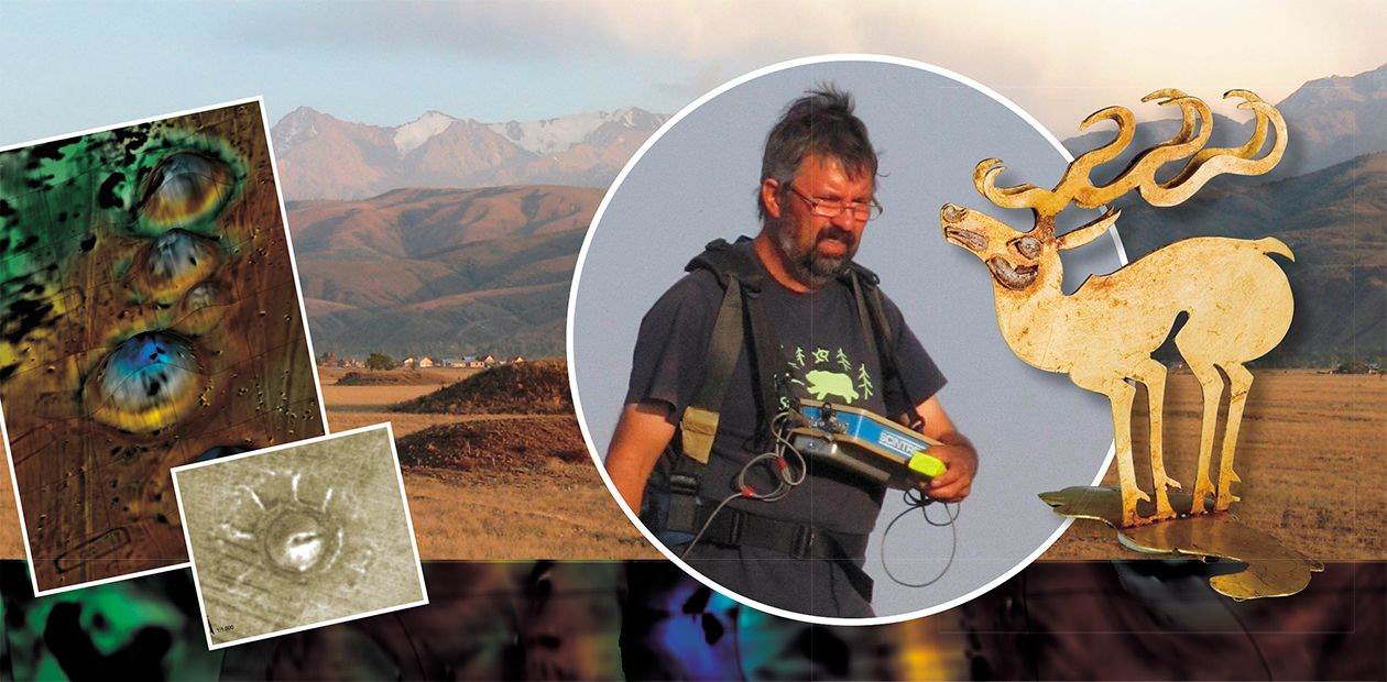
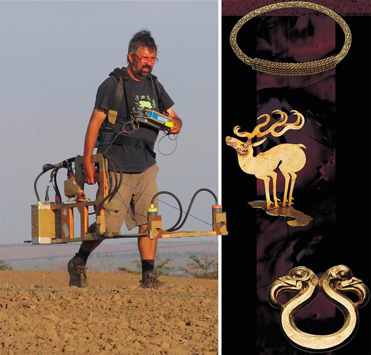
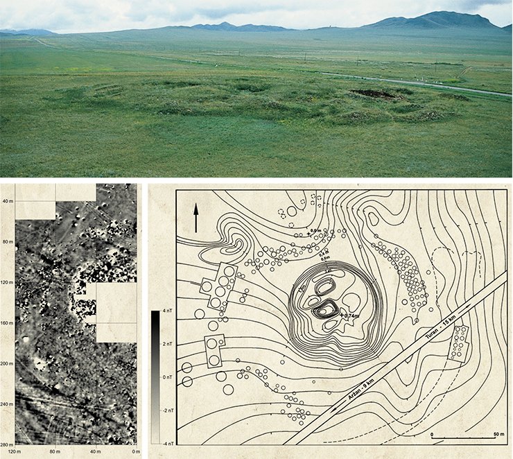
To carry out these studies, we decided to consign the geophysicist Jörg Fassbinder and an expert on archaeogeophysical prospecting who had done similar research in these areas (Fassbinder, 2009; Korobov et al., 2014). The geophysical approach was essential in this study because it allowed us to obtain, very quickly, detailed information about the structure of the kurgan periphery beneath the soil and about the burial ground as a whole. Using a highly sensitive cesium magnetometer, we were able to generate a magnetogram image that was very similar to a computer tomogram or an X-ray image of the subsurface. This magnetogram reveals even the weakest and smallest magnetic differences in the soil down to a depth of about 3 m and uncovers even the smallest archaeological structures. As a result, it was possible to draw a detailed archaeological map of all the ancient features beneath the ground caused by former and ancient digging and covering pits, by old building hollows, by stone constructions, as well as to detect kilns or fireplaces and any other traces of human activities. It was also possible to detect traces of natural phenomena such as ancient river beds or lightning strikes.
To sum it up, magnetometer prospecting enables archaeologists to obtain information about any constructions on the periphery of the mound that are not visible from above the ground. This makes the fieldwork for archaeologists much easier. Of course, the results of the magnetometer measurements itself cannot replace a dating method and thus cannot prove whether the sites under study belong to the same or to another period. This can be done only by means of archaeological excavations.
In the land of seven rivers
In 2008–2009, the first step in the archaeogeophysical study of the kurgan periphery was made in Southeastern Kazakhstan, in a place called Land of Seven Rivers, which is mostly known for the impressive discovery of “The Golden Man,” a Saka warrior from the Issyk mound near Almaty. Most “elite” kurgans in this region are located in steppe plains, at the foot of the Tian Shan, along the Trans-Ili Alatau. The research materials from the Land of Seven Rivers mounds became known to the scientific community back in the 1960s–1970s, but no attention was paid to the periphery of the mounds because the area around the kurgans had been significantly damaged by repeated plowing.
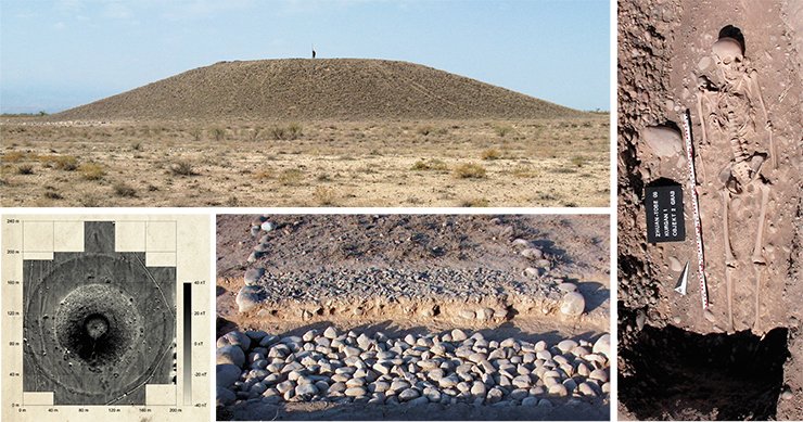
While examining the sites of southeastern Land of Seven Rivers, we paid attention to the ditches, ramparts and stone rings around the large mounds that were located singularly or in groups. Of particular interest were the double stone rings located at a distance of 0.5 to 5.0 m from each other, with single middle-sized river pellets between them. The periphery of one of those large kurgans was studied in the framework of the joint Kazakhstan-German expedition headed by Z. Samashev (Kazakhstan) and by H. Parzinger and A. Nagler (Germany). It was the largest and, presumably, major mound among the nine kurgans of Žoan Tobe burial grounds located to the east of Almaty.
The double stone rings were located at a distance of 33 m from the foot of kurgan 1, the distance between them being 3.0 to 3.5 m so that the overall diameter of the construction reached 185 m. In the area between the double rings and the foot of the mound, we also discovered 28 round stone constructions—small mounds with a diameter of 4 to 7 m. Some of them were visible on the surface, but their total number was found owing to the geophysical survey.
Later, it became clear that such smaller stone mounds had been made over burial pits for one single person, but since no burial instruments were found, only radiocarbon analysis could help in dating the bones. The analysis of a phalanx from one of the graves allowed us to date it the 10th–11th centuries BC, which means that at the foot of the large Saka kurgan of the 5th century BC there was at least one burial mound of the early Turkic period, the period of Kara-Khanid Khanate. Whether the other 27 smaller kurgans were constructed in the Early Middle Ages or much earlier is the matter of further studies.
The double stone rings were studied by two trench excavations in the northern and eastern sectors. As shown by the excavations, the stone rings were the elements of one construction—a sort of bordering for the central part rammed and cobbled with middle-sized paving stones. This foundation was covered with a layer of compacted clay mixed with fine gravel. The higher central part of the construction provided excellent water drainage during the rains. Thus, the whole construction could be generally identified as a road.
Since the road stretches around the mound, it is likely to have been built for ritual purposes by the Saka tribes who inhabited this region in the Early Iron Age. Unfortunately, it is impossible to say whether it was built before the construction of the mound or later. Nor is it possible to be quite certain that it was built by the Sakas since no items characterizing the time of its construction were found. Yet, the results of studying all the periphery elements of large Scythian-Saka mounds in the steppe and forest-steppe of Eurasia testify to the fact that “ritual roads” were a part of sacred constructions that encircled the burial mounds of ancient nomads.
Similar circular “roads” were discovered at around 18 kurgans of the nine Saka burial grounds located in the foothill areas and in highland valleys of Trans-Ili Alatau in the southeastern Land of Seven Rivers. The scale of the construction was always proportional to the scale of the mound. So far such “ritual roads” have not been found anywhere else in Eurasia within the spread of Scythian-Saka cultural-historical community (Gass, 2011; Nagler, 2013).
Pyramids of the steppes
Going back to Žoan Tobe burial grounds, it is necessary to mention the second largest mound in the eastern chain, shaped as a truncated pyramid, with its slopes oriented to the cardinal points. Similar “steppe pyramids” were discovered in other kurgan chains of the same necropolis. Ten different burial grounds in the southeastern Land of Seven Rivers have 16 square-shaped kurgans with pyramidal mounds and flattened tops. The “ritual roads” constructed around such mounds were also designed in a sub-square shape.
Before our research in the Land of Seven Rivers, similarly shaped mounds were known only in South Siberia (in the Republic of Khakassia and in the south of the Krasnoyarsk krai), where the Tagar culture of the Scythian world had existed. Another square-shaped ditch was found around Scythian kurgan 22 near the village of Volchansk in the Utlyuk Interfluve, north of the Azov Sea. However, as the mound itself had been heavily plowed, it was impossible to reconstruct the initial form (Mozolevsky and Polin, 2005). All this allows us to suggest that large mounds of a square pyramidal shape were constructed by ancient nomads not only in Siberia, but also in Central Asia.
Obviously, the shape of the mound was not accidental, though we cannot give a satisfactory explanation for it yet. The excavations on the site of a similar square shaped mound in the Žoan Tobe burial grounds could not clarify the problem either. Heavily plowed, kurgan 8 seemed to be round, but the geophysical survey revealed clearly that initially it had a square shaped monument. To prove this, we studied a neighboring burial mound, kurgan 9, which turned out to have had a classic rounded shape of the Scythian-Saka burial mound. Regrettably, these kurgans are so heavily damaged that we could not identify any details indicating the reasons for building structures of such different shapes.
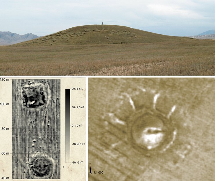
Luckily, not all of the ancient kurgans’ mysteries remain unraveled. Thus, in 2008, exploring the highland plateau Kegen near the Kazakh-Kyrgyz border, we found a single large mound of the Saka period on the Kazakhstan side; it was based on a one-meter-high square platform with rounded corners, the total height of the construction was 13 m. A topographical mapping by a GPS and an overlay with the satellite image, showed five curious star shaped “rays,” which were 8 to 10 m wide and ca. 60–100 m long, extending from the mound west and north. The subsequent geophysical measurements revealed, however, only the traces of the ancient construction activity, but no construction themselves: the cesium magnetometer measurements were able to clarify the situation. We really saw “the rays” only in the satellite image!
Three excavations in the northern part of the periphery helped to solve the mystery of this situation. The five “rays” were the remnants of building ramps leading to the basement and to the foot of the mound. The earth from the “ray” area was used as building material to construct the mound; after the construction was completed, those ramps were not destroyed. So, the diameter of the whole construction of the mound turned out to be at least 330 m. Perhaps, previously, such ramps had also extended east and south, but intensive plowing completely destroyed all of their traces.
The huge and large burial mound, kurgan 2 on the Kegen plateau, was once, certainly, very impressive, both in size and bright colors: the green of the steppe, the dark black color of the soil, and the yellow color of the loess and clay of the “rays” against a crystal clear blue sky above the Tien Shan. All three elements of the kurgan—the ramps, the platform, and the mound—made it an extraordinary monument, which impressed travelers for over 2,500 years, and it is still impressive today. While Scythian-Saka mounds based on the platform have single analogs in the foothills of Tarbagatai, Eastern Kazakhstan (the Aksuat burial grounds; Samashev et al., 2010) and in Northern Caucasus (Asiatsky Kurgan), the traces of building ramps at the mounds of ancient nomads are actually unique.
The kurgans of Semirechye keep many other secrets and archaeological mysteries, but our interest in exploring the periphery of large mounds inspired us to move further, following the Saka trail towards the “sunset.”
Looking to the west
In 2010, Zeynolla Samashev (Astana) drew our attention to the Tört Oba burial grounds near the village of Zhirenkopa in the northwest of the Aktobe oblast (Kazakhstan), located near the border with the Orenburg oblast. The burial grounds include five mounds forming a line from west to east. Each kurgan was surrounded by a ditch, the kurgans located so close to each other that some ditches joined and partly crossed one another.
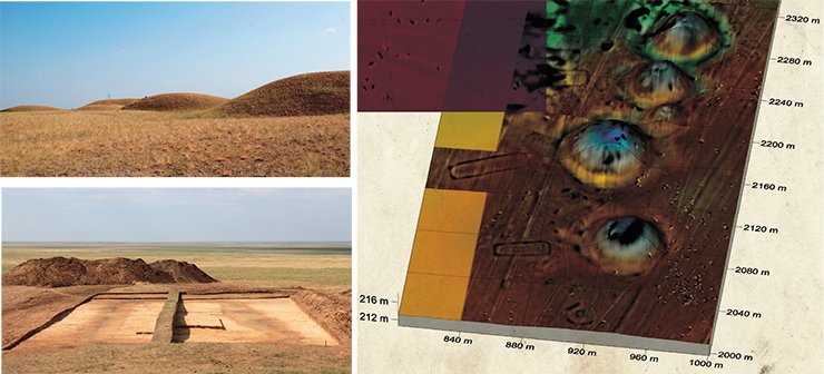
The 2011 results of the geophysical prospecting of the kurgans’ periphery exceeded all expectations. Many small mounds not visible on the surface, single graves, ritual pits and sacrificial complexes were detected around every kurgan. Moreover, on the south side of each kurgan, we detected a rectangular ditch construction beneath the soil. Such features were previously unknown to science; the size of the ditch was ca. 13 × 39 m, extending from north to south. The excavations of the periphery of the easternmost kurgan discovered sacrificial complexes with the remnants of ceramics, items of harness and a bronze cauldron. Here we also studied a number of burial mounds.
The examination of the rectangular construction of an unknown purpose showed that the ditch was 1.0 to 1.8 m deep with a bottom width of 1 m. The material which filled the ditch contained ash, wood charcoal and animal bones arranged in a particular way. Since no traces of the ditch dislodging were detected, it was concluded that the ditch had been filled by ancient builders after a short-term use. Obviously, we can talk about a ritual construction erected for a particular ceremony held at the foot of the kurgan. The results of the radiocarbon dating of the animal bones demonstrated that the whole structure had been created at the same time as the mound (7th–5th century BC).
The 2011 test magnetic prospecting of the neighboring Besoba burial grounds gave a magnetogram image nearly identical to the one of the previously studied necropolis. The natural question was whether the ritual platforms constructed by the ancient nomads on the southern periphery of the large Scythian-Saka burial mounds for certain religious beliefs and ceremonies were a local variation typical only of Western Kazakhstan and the bordering the Orenburg oblast, or we have simply not yet discovered such constructions due to the lack of knowledge about the periphery of large kurgans. Surprisingly, the answer to this question was found in Northern Caucasus.
Scythians of Northern Caucasus
From 2012 our research group participated in the joint Russian-German archaeological expedition in Northern Caucasus (Stavropol krai) together with the SUE Heritage headed by A.B. Belinsky (Russia) and by H. Parzinger and A. Gass (Germany). While planning our activities we also used every chance to go and observe unfamiliar sites. One of them was Zunkar-2 burial grounds in the Nogai steppe in the easternmost part of the Stavropol krai.
The first impression of the necropolis was like a déjà vu: it was as if we were on the famous Issyk burial grounds in Semirechye again; the only thing missing would be the Trans-Ili Alatau mountain ridge on the horizon. In fact, we were able to start exploring the Nogai steppe only in the spring of 2014.
Zunkar-2 consists of three kurgan chains aligned from north to south, each including 5 to 10 mounds. It is located on a small hill protected from melt water during spring floods. To the north of the necropolis, there is a field where earlier there were small mounds now completely ploughed down. Along the border between the steppe and the field, there is an electric power line causing heavy interference in the magnetic signal; as a result, the magnetometer was applied only to the southern area of the burial grounds, which included three mounds of 30–50 m in diameter and one smaller mound.
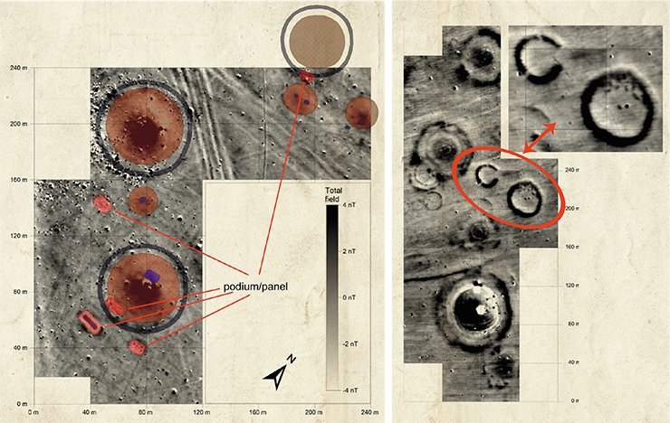
The magnetogram image of the necropolis showed that the large mounds were surrounded by ditches, and that there were additional small mounds and several pits of unknown character. Of particular interest were sub-rectangular constructions to the south of the large mounds, which were quite similar to the constructions found in western Kazakhstan. However, there were a number of external differences between similar constructions in north-eastern Caucasus and commemoration platforms in the Aktobe oblast. The rectangular constructions of Zunkar-2 were much smaller (the size being 10×15 m and 10×20 m) and oriented east–west, i.e., along the mound rather than north–south, as in Tört Oba and Besoba.
Since no search boreholes or trench excavations on the periphery of the large mounds of the Zunkar-2 necropolis have yet been made, one cannot say for sure whether the periphery rectangular constructions of these kurgans are similar to the ritual platforms near the Saka kurgans of western Kazakhstan. For the same reason we cannot say whether these constructions were erected at the same time as the mounds. But the fact of their discovery, similarity of the shape and the location of the large mound on the periphery allow us to presume that the religious beliefs of the Early Iron Age nomads both in the Nogai steppe and in the western Kazakhstan steppe were the same, and they practised similar burial rituals. We will be able to know if this is true only after excavating the periphery of the Zunkar-2 mounds.
Thus, throughout the Eurasian steppe belt, from Tuva to Northern Caucasus, almost every investigated Scythian-Saka necropolis with burial mounds of the ancient nomadic elite showed the traces of intensive cultic activity embodied in various constructions on the kurgan periphery. It can be assumed that throughout the Eurasian steppe and forest-steppe every large mound of the Scythian period had a spot of “intensive” ritual activity on the periphery.
The 2012 results of geophysical measurements of the Vinogradny necropolis (Stavropol krai) became a vivid confirmation of this assumption. The Vinogradny 1 kurgan is composed of one large kurgan (5.4 m high and 58 m in diameter) and at least 14 smaller burial mounds. As the entire burial grounds are arable land today, only the large mound remains untouched while its foot and the encircling ditch are significantly damaged.
The magnetometer measurements of the necropolis revealed again outstanding results: not only the area around the kurgan, but all the area of the burial grounds (5.2 hectares) was densely covered with the objects and constructions on the periphery. We found many small mounds not visible on the surface, semi-circular extensions of large mounds with ditches, pits, single burial mounds, horseshoe-shaped and round constructions of unknown purpose. Besides, there was a system of rectangular ditches connected with each other and forming a kind of fence with catacombs inside, which has parallels with the Alan period burial mounds in the Kislovodsk hollow (Korobov et al., 2014). Some of these constructions were identified as ditches filled with organics, ash and wood charcoal. Whether there had been a fire in the ditches or only highly magnetic ashes, is hard to say if we rely only on the magnetometer data. According to the radiocarbon dating, at least one of these constructions, the horseshoe-shaped ditch, was erected in the Scythian period of the Northern Caucasus history, which links it with the large mound of the burial grounds.
As for the rest of the cultural-religious constructions, it is difficult to identify their age without excavations. The only exception is the central burial mound of the kurgan with an extension in the southern part of the necropolis; examining its bone material made it possible to date it the end of the 4th millennium BC. Thus, we can imagine a picture of ritual activity in the limited area, connected with the burial cult, covering the period from the Early Bronze Age (Maykop culture) to the Early Iron Age (Scythian period) and, possibly, to the period of the Middle Ages (Alan culture).
However, quite a different use of the mound periphery was discovered at the Vinogradny-2 necropolis, located 3 km from Vinogradny-1. These two burial grounds are very much alike, though Vinogradny-2 includes nearly 80 mounds, and its “royal” mound is larger. Starting the geophysical prospecting of the necropolis, we expected to surpass the results obtained in Vinogradny-1. But except the clear outline of the ditch around the large mound and the plowed ramp encircling it, as well as several small mounds and grave pits at the foot, the periphery of the mound turned out to be almost “empty.” The periphery of the large mound of the Vladimirovka necropolis to the east of Budennovsk was also “empty.”
Thus, we discovered two different types of ritual use of the periphery of large mounds in Northern Caucasus. Without carrying out excavations, it is impossible to determine if this was due to the social status of the buried, to sex or age differences, or to their cultural differences, to say nothing about the chronology of constructions. Despite the many years of our efforts there is still a long way to go, and the Scythian kurgans in the boundless steppes of Eurasia will still keep their secrets…
References
Belinsky A.B., Parzinger H., Gass A., Fassbinder J. Issledovaniya bol’shikh kurganov epokhi rannego zheleznogo veka Severnogo Kavkaza i ikh periferii s primeneniem magnitometrii (Magnetometry studies of large Early Iron Age kurgans of the Northern Caucasus and their periphery // Proc. 4th (20th) All-Russian Archaeol. Congress, Kazan, 2014. Kazan: Otechestvo, 2014. Vol. 2. P. 83–87 [in Russian].
Bidzilya V.I. and Polin S.V. Skifskii tsarskii kurgan Gaimanova mogila (Scythian Royal Kurgan Gaimanova Mogila). Kyiv: Skif, 2012 [in Russian].
Veselovsky N.I. Zapiska po voprosu o priemakh pri proizvodstve raskopok (Note on excavation techniques) // Proc. 14th Archaeol. Congress 1908. Moscow: Lissner & Sobko, 1911. Vol. 3. P. 99.
Gass A. Early Iron Age burials in Southeastern Zhetysu: the geoarchaeological evidence // Archaeology, Ethnography and Anthropology of Eurasia. 2011. N 3 (39). P. 57–69.
Korobov D.S., Malashev V.Yu., and Fassbinder J. Predvaritel’nye rezul’taty raskopok na kurgannom mogil’nike Levopodkumskii 1 bliz Kislovodska // Krat. Soobshch. Inst. Arkh. 2014. N 232. P. 120–135 [in Russian].
Mozolevsky B.N., Polin S.V. Kurgany skifskogo Gerrosa IV v. do n. e. (Kurgans of the Scythian Gerros, 4th Century BC), Kyiv: Stilos, 2005 [in Russian].
Čugunov K. V., Parzinger H., Nagler A. Der skythenzeitliche Fürstenkurgan Aržan 2 in Tuva. Archäologie in Eurasien 26. Steppenvölker Eurasiens 3. Mainz am Rhein: Verlag Philipp von Zabern, 2010.
Fassbinder J. W. E., Geophysikalische Prospektionsmethoden – Chancen für das archäologische Erbe // Toccare – Non Toccare. ICOMOS. Hefte des Deutschen Nationalkomitees. München: Siegl, 2009. Vol. 47. S. 8—30.
Nagler А. Grabanlagen der frühen Nomaden in der eurasischen Steppe im 1. Jahrtausend v. Chr. // Unbekanntes Kasachstan. Archäologie im Herzen Asiens. Kat. der Ausst. des Deutschen Bergbau-Museums Bochum vom 26. Januar bis zum 30. Juni 2013. Bd. II. Bochum: DBM, 2013. S. 609—620.
Parzinger H. Die Reiternomaden der Skythenzeit in der eurasischen Steppe // Unbekanntes Kasachstan. Archäologie im Herzen Asiens. Kat. der Ausst. des Deutschen Bergbau-Museums Bochum vom 26. Januar bis zum 30. Juni 2013. Bd. II. Bochum: DBM, 2013. S. 539–553.
Polin S., Daragan M. Das Prunkgrab Alexandropol‘-Kurgan. Vorbericht über die Untersuchungen in den Jahren 2004–2009 // Eurasia Antiqua. 2011. N 17. S. 189–214.


