From Chicxulub to Chelyabinsk
Cosmic Catastrophes on the Earth
When scientists talk about the danger of cosmic catastrophes on the Earth, are they only fantasizing? Or is this danger indeed a reality we choose to ignore? Back in December 2004, the International Council of Scientific Unions (ICSU) held a conference on Comet and Asteroid Impacts and Human Society. Scientists and experts from 18 countries attempted to attract the attention of the world scientific community to the danger coming from the cosmos. The reports and discussions presented compelling evidence of at least three global catastrophes of cosmic origin with enormous consequences to climate and to human habitats.
These catastrophic events, which befell the Earth after the last glaciation, are the object of research for the Holocene Impact Working Group (HIWG), established after the conference. A decade ago, the author of this article, one of the HIWG founding members, published an article where he gave key evidence for a cosmogenic theory of these global cataclysms. Now he is revisiting this topic, since many new observations and facts have accumulated over the past years, not to mention such events as the 2013 Chelyabinsk meteorite in Russia, a real cosmic body impact that created a nationwide emergency. This article presents an analysis of today’s perspective on the reality and realness of cosmic threats to modern civilization
Madagascar is the fourth largest island in the World Ocean. Some even call it “a small continent” because of its huge diversity of plant and animal species, most of which have not been found elsewhere in the world.

September 2006. Our expedition team reaches the southernmost tip of the island, where Google Earth shows four systems of huge sandy dunes stretching dozens of kilometers inland from the coastal zone. We are standing on the top of one of these dunes and looking towards the southwest, from where a warm steady wind blows into our faces. To the right lies a bright blue strip of the Indian Ocean, fringed with a white line of the surf, carrying echoes of the “roaring forties” a thousand kilometers to the south. For millennia, this surf has been eroding the cliffs and rocks of Madagascar, turning them into sand, which accumulates on the beaches and underwater slope of the island. We look around to see the same sandy hills, tens of meters high, stretching far out to the horizon.
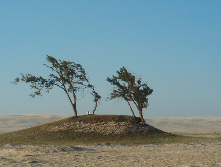

We are thinking about the force that was able to lift this gigantic – at least 1 km3 – volume of sand from the coastal zone and carry it so far inland. This force could have come from a devastating tsunami, arising from somewhere in the southwest Indian Ocean. However, there are no large faults in the Earth’s crust in that region, and no strong enough earthquakes or volcanic eruptions happen there. This means that such a tsunami could have only been caused by other mechanism – for example, by the impact of a large meteorite or comet.
“Stones cannot fall from the sky”
Attitudes towards space hazards have been changing markedly throughout human history. For primitive humans, who spent most of their life in the open air, observation of the sky in an attempt to understand celestial phenomena was an integral part of everyday life. Indigenous people of Australia would see bright-tailed comets, sky-crashing tree-falling explosions, and meteorite impacts, leaving huge craters – all these phenomena were commonplace for those people as they had witnessed them for tens of thousands of years and firmly imprinted them in their myths, rituals, dances, and rock art.
Neither the ancient Egyptians nor the Greeks considered meteorite impacts supernatural. The dagger in a gold sheath, found in 1925 next to the mummy of Tutankhamun, was made of meteoritic iron – as early as in the 13th century BC, the Egyptians knew about the celestial origin of this then-rare metal. People were also aware of meteoritic iron both in the Hittite kingdom and in Crete during the Minoan era.
. Gallery of Mineralogy and Geology of the French National Museum of Natural History in Paris. © Marie-Lan Taÿ Pamart") From antiquity to the early Middle Ages, people had shared a firm belief in the celestial origin not only of stone and iron meteorites but also of other unusual objects they would find by chance or during agricultural work. These objects included the tools and implements of ancient people (stone chisels and spearheads), fossil sea shells, formidable shark teeth (it was believed that they fall to the Earth from the sky during lunar eclipses), and many more.
From antiquity to the early Middle Ages, people had shared a firm belief in the celestial origin not only of stone and iron meteorites but also of other unusual objects they would find by chance or during agricultural work. These objects included the tools and implements of ancient people (stone chisels and spearheads), fossil sea shells, formidable shark teeth (it was believed that they fall to the Earth from the sky during lunar eclipses), and many more.
However, during the Renaissance, all of these facts were either forgotten or denied as the spawn of dark and ignorant people. For a long time, the progressive European science had been gainsaying the possibility of solid bodies falling from “heavenly palaces above,” where they simply could not have been in accordance with the law of universal gravitation, discovered by the great Isaac Newton. Neither eyewitness accounts, such as the dazzling fireball seen on November 7, 1492 over Alsace, nor the 150-kg black stone found in a deep crater near the town of Ensisheim were capable of shaking the skepticism of scientists, who firmly believed in the infallibility of the laws of nature they had discovered.
“Stones cannot fall from the sky because there are no stones in the sky!” Such was the verdict passed by a special council of the Parisian Academy of Sciences in 1772. Newton himself believed that small bodies could not exist in space beyond the orbit of the Moon. There could be no source of material for stones in the heavens unless the stones had formed in the upper atmosphere as a result of dust particles sticking together under the influence of lightning or unless they had gotten into the sky during volcanic eruptions.
The event on April 26, 1803 changed their minds. Witnessed by many, a meteor shower fell over the commune of L’Aigle in Brittany and ended the long-standing confrontation between facts and science. The news quickly reached Paris. A young astronomer Jean-Baptiste Biot (the future author of the Biot–Savart law), representing the French Ministry of the Interior, conducted a thorough field investigation and submitted a detailed report to the Academy, where he argued in favor of the celestial origin of the stones, which had fallen in large numbers (up to three thousand). The stones were found to contain a large amount of nickel, a rare element in terrestrial rocks, and nickel was then considered by many geologists to be a substance of cosmic origin.

It was only then that the French Academy of Sciences officially recognized the extraterrestrial origin of meteorites, after it had been stubbornly denying for a century the numerous reports of meteorite falls for the sole reason that those events were witnessed, as a rule, by illiterate peasants and mediocre people.
Modern catalogues and databases contain information on roughly two hundred proven impact (i. e., of a shock explosive origin) craters on the Earth’s surface. Several hundred ring structures are awaiting confirmation of their origin. The ages of the proven impact craters vary wide: from 2.1 billion years (the 300-km Vredefort crater in South Africa) to historically recent (the crater field in the Far East of Russia, created by the fall of the Sikhote-Alin meteorite in 1947).
End of the era of dinosaurs
It is believed that the “era of dinosaurs” came to an end through a cosmic catastrophe evidenced by Chicxulub, the third largest crater among the known impact structures.
, maintained by the Tsunami Laboratory of the Institute of Computational Mathematics and Mathematical Geophysics, Siberian Branch, Russian Academy of Sciences (Novosibirsk). As of today, the EDEIS contains information on 1190 impact structures. The size of colored circles is proportional to the crater diameter")
The very idea that the mass extinction at the turn of the Cretaceous and Tertiary periods could have been caused by an impact of a large asteroid was put forth by the Nobel Prize winner Luis Alvarez in 1980. In an article published in Science, he and his colleagues reported the discovery of a high content of iridium and other platinum group elements in a thin clay layer occurring in several outcrops of limestone strata, dated to that period, in Italy, Denmark, and New Zealand. According to scientists, such a high content could be a consequence of a large asteroid impact about 65 million years ago.
In order to cause a global catastrophe, the asteroid ought to have fallen somewhere within the equatorial belt, to have had a diameter of about 10 km, and to have left a crater with a diameter of about 200 km. Back then, no craters of so large a size were known on land, and the authors of the article assumed from the very beginning that finding such a crater would not be easy.
However, as early as in the following year, an analysis of gravitational and magnetic maps of the western Gulf of Mexico was presented at a conference of the US Society of Exploration Geophysics. The report revealed an area of unusual concentric anomalies with a maximum diameter of 200 km. That structure, which was interpreted as the remains of a large paleovolcano or impact crater, was later named Chicxulub after an Indian village on the northern coast of Yucatan. Subsequent studies, including by drilling, revealed many signs of its impact origin, up to geological traces of a powerful tsunami that swept through the territory of modern Texas.
 data. The rim of the crater is marked by a depression, “outlined” by a dark green semicircular curve. Below is a Landsat image showing different types of vegetation and soil cover in colors corresponding to different infrared bands. The depression is not visible in this image. © NASA. An image of the gravitational anomaly in the neighborhood of the Chicxulub crater. The image was created on the basis of the NASA map. © Milan Studio")
The process of proving the impact origin of a given ring structure is complex, laborious, and time-consuming and it may stretch in some cases for years and even decades. It involves collecting evidence on four levels, at least. The first one is morphological (landscape) level, i. e., the presence of an edge rim, radial faults, and a central uplift (for large craters). The second one is geological level which focuses on the presence of crushed and molten rocks and impact cones, i. e., specific formations that emerge in target rocks only under an instantaneous (shock) impact of high pressures. The third level, a petrological one, involves the search for rocks and minerals whose formation is associated with high pressures and temperatures. And finally comes the microlevel, the most important one in the entire chain of proof, which involves the search for minerals such as coesite and shtisovite (impact quartz) and characteristic defects in the crystal structures of mineral grains.
For the first proven impact structure – the Barringer crater in Arizona, about a kilometer in diameter – this process took almost half a century. The meteorite hypothesis for Lake Chiemgau in eastern Bavaria still needs to be defended by its supporters despite all the evidence collected at four levels (except for the presence of impact quartz)
The scientific community accepted the impact hypothesis for the ring structure on the Yucatan Peninsula, and the Chicxulub crater was included in the reference base maintained by the Planetary and Space Science Center of the University of Quebec (Canada). Subsequently, in 1991, Hildebrandt and his colleagues officially suggested that Chicxulub was indeed the structure whose formation caused a global catastrophe accompanied by mass extinction.
However, not all geologists and paleontologists happened to be on the same page. The opponents would emphasize the fact that the extinction process lasted many tens or even hundreds of thousands of years. As an alternative, they proposed a hypothesis that dinosaurs could have died from abrupt changes in the composition of the Earth’s atmosphere due to the degassing of the Earth’s interior during an episode of global basaltic volcanism as it was the time when, for example, the famous Deccan basalt plateau was formed, covering virtually all of the central India. But it was argued that the very outpouring of basalts in India (at almost an antipode to Yucatan) could have been initiated by the fall of an asteroid, puncturing the Earth’s crust as deeply as many tens of kilometers.
 with the Nobel laureate Luis Alvarez and his wife Milly on a geological tour to Europe’s largest meteorite crater Siljan in Sweden. Photo by the author")
A well-known supporter of the catastrophe theory A.A. Barenbaum (2010) believes that a single impact of even a large asteroid could not have caused such a massive extinction event, which affected not only dinosaurs but up to a third of all other biota. The catastrophic change in the biotic environment could have ensued from an intense bombardment of the Earth by galactic comets, an ongoing process lasting several hundred thousand years. The scientist grounds this idea in the fact that in geology, the entire geochronological scale, let alone the Cretaceous–Paleogene boundary, is a reflection of catastrophic bombardments of the Earth by cometary showers, which hit the planet when the Solar System was passing through the galactic arms.
“And Comet wine’s soon gushing out…”
In recent years, more and more publications have presented evidence of rapid global-scale changes in the Earth’s climate during the Holocene (last twelve to thirteen thousand years) and their substantial impact on the biosphere and the course of historical processes.
, an asteroid with a diameter of about 10 km crashed into the Earth where now the Yucatan Peninsula is. This event created the famous Chicxulub crater. A huge amount of debris thrown into the atmosphere settled all over the Earth, forming the so-called C–T boundary clay layer. Right: C–T boundary clay sample from the southeast of Spain with a 2–3-mm yellowish-orange oxidized iron layer at the base, enriched in chemical elements (Ir, Co, Cr, and Ni) from the bolide. © James St. John")
Being global in scale and interdisciplinary in nature, the question about the sources and mechanisms of propagation of these rapid climate changes sparks acute debate. A considerable number of specialists (astronomers, geologists, archaeologists, historians) ignore their very existence, considering the data of other sciences to be fragmentary and contradictory and, therefore, unreliable.
Scientists in other disciplines dealing with the direct observation and recording of various natural trends do not deny the existence of global anomalies, but opinions differ regarding their causes. Suggestions include, for example, large volcanic eruptions, dust storms, long-term droughts, or smoke from long-term fires. Meanwhile, geologists and climatologists point to at least three global climate catastrophes during that period, clearly of a cosmic origin (cometary or asteroid impacts), i. e., about 12,800 and 4,400 years ago and in the year 536 AD.
, and their replicas are on display all around the world. © Mike Beauregard")
Nevertheless, the prevailing paradigm in history and archeology builds upon a conviction that the absence of direct evidence of any cosmic influences is the evidence that they did not affect the course of human history, at least since the inception of writing, i.e., in the last five to six thousand years.
This point of view is shared by many representatives of the astronomical community dealing with the problem of collisions of the Earth with asteroids and comets. Their main method is to count small cosmic bodies in the Solar System, which can come dangerously close to the Earth. They estimate the average frequency of collisions between the Earth and large (about 1 km in diameter) asteroids at about one million years. Therefore, the probability of a major cosmic catastrophe during the Holocene, i.e., over a period of twelve thousand years, is less by two orders of magnitude (about 1 %).
; top right: engraving from the French magazine Le Magasin Pittoresque (1853). Public domain")
The collection of facts testifying to the vast heterogeneity of climate on the Earth in the Holocene is growing rapidly through both new observational data (long dendrochronological series, borehole logs for Greenland and Antarctic glaciers, lake sediments, and samples from peat bogs, coral reefs, and cave deposits) and the development of sophisticated analytical methods of analysis and dating (SEM photographs, microprobe analysis).
Biological evidence includes the sudden disappearance or arrival of new animal and plant species and tree-ring anomalies; historical and archaeological evidence includes population fluctuations, sudden migrations, demolition of cities, or desolation of long-inhabited lands.
Social sciences, too, contribute to this research. In recent decades, a large body of evidence was put into scientific circulation, the evidence of unusual natural phenomena, previously scattered across folklore tales, legends, sagas, fables, and myths collected around the world. Researchers are beginning to realize that most of these stories are rooted in real astronomical and natural events that had had so significant consequences for primitive communities that they were “recorded” in oral legends, symbols, and ancient traditional rites of almost every nation
Modern science appears to underestimate the space hazard also because the 20th century turned out to be relatively poor in bright celestial events. In the 19th century, for example, people witnessed about a dozen large comets and several impressive meteor showers, as reflected in paintings and literature. Here, we might recite from Eugene Onegin, a novel in verse by Alexander Pushkin, “And Comet wine’s soon gushing out…” These words refer to a bright comet observed in August–December 1811, which was immediately associated by Russians with the expected invasion of Napoleon.
. Photo by E. Bryant")
The frequency of major regional catastrophes such as the fall of the Tunguska meteorite is now estimated by astronomers at one thousand years. However, in reality it may be much higher if we remember that the last century alone saw at least two large-scale fireball events: on the border of Peru and Brazil in 1930 and in British Guiana in 1935. And in the last quarter of the 18th century, an even more powerful explosion appears to have occurred over the southern coast of Australia. Not to mention the fact that three quarters of the Earth’s surface is occupied by seas and oceans, where the likelihood of recording such events is extremely small.
At the turn of the Holocene
The greatest climate catastrophe, affecting the entire northern hemisphere of the Earth, occurred at the turn of the Holocene about 12,800 years ago. In that period, the climate warming, which began after the last ice age, was suddenly interrupted by an event known as the cooling of the Younger Dryas, which lasted almost 900 years. The episode of cooling itself, which occurred, paradoxically, at the time of an intense melting and retreat of glaciers, has been known to geologists since the end of the 19th century, but they had only guesses regarding the causes of that event.
A new and rather unexpected hypothesis for a mechanism underlying that cooling was proposed by the physicist R. Firestone and the geologists A. West and S. Warwick-Smith in 2006. Based on an analysis of a large array of data, these scientists came to the conclusion that the most probable physical mechanism explaining the entire set of facts associated with the drastic change in the climate of the Northern Hemisphere in the Younger Dryas resides with a cometary impact on the ice sheet that covered Greenland and most of Canada at that time.
. © NASA's Scientific Visualization Studio")
This cosmic catastrophe caused the demise of virtually all animals in North America weighing over 40 kg and the rapid loss of the Clovis Stone Age culture, previously widespread across the North American continent. The destruction of the glacier caused the release of huge masses of fresh water into the Atlantic and the Gulf of Mexico, the water that had accumulated in periglacial lakes as a result of gradual melting of the glacier. The water release induced a change in the Gulf Stream regime and, hence, impacted the climate of all Eurasia. In the meantime, fires in the prairies and forests of North America put smoke particles into the stratosphere, as evidenced by a sharp increase in the concentration of soot and other particles in the corresponding layers of borehole samples from the Greenland Ice Sheet.
The impact hypothesis explained dozens of other facts and observations from a wide variety of disciplines, including, e. g., the mystery of the so-called Carolina Bays, i. e., shallow elliptical depressions hardly noticeable on land yet clearly visible in the satellite images of North and South Carolina.
The weak point of this hypothesis was the lack of evidence of a crater at the site of the alleged cometary impact. However, a report appeared in 2018 that a large circular depression, called the Hiawatha crater, had been discovered using a sonar in the western part of the Greenland Ice Sheet (Kjaer et al., 2018). A crater with a diameter of 31 km lies hidden underneath an almost 1-km ice layer but manifests itself in bedrocks. Its age is estimated at about 13,000 years. The size of an impactor capable of leaving such a crater must be about 1.5 km, which exceeds the minimum size of a cosmic body capable of causing a global climate catastrophe.
 in Arizona with a diameter of 1200 m and a depth of 180 m was created by a relatively small, 50-m iron meteorite, which fell here about 50,000 years ago. © Ivy Mike")
Despite the discovery of this gigantic crater, the impact hypothesis of a catastrophic beginning of the Holocene is still being attacked fiercely by its opponents, of which there are many. The critics, however, provide no alternative explanations for the core facts underlying the hypothesis, leaving them as well as hundreds of other pieces of evidence of the drastic climate changes in the Northern Hemisphere outside the scope of discussion.
To be fair, certain explanations for these phenomena are indeed presented. One such explanation is the so-called overhunting hypothesis for the disappearance of mammoths and woolly rhinos in Eurasia. However, the advocates of this hypothesis pay little attention to facts, sparing themselves the effort to compare the size of the mammoth populations (nearly five million specimens, according to some estimates) with that of human inhabitants of Eurasia, whose number hardly reached one hundred thousand. Whereas the study of food preferences in ancient people by analyzing the composition of bone remains at camp sites shows that their food base was reindeer and geese, both of which make much tastier and much more accessible prey. Thus, as Lev Gumilev wrote (on another occasion), any attempts to clearly formulate such hypotheses demonstrate, best of all, their inconsistency.
Footprints in the sand
The catastrophe of the Great Flood, which appears to have befallen the Earth about 4,500 years ago, is one of the best known cataclysmic events in ancient history. In fact, this event gave rise to geology as a science since the first naturalists sought to explain all the visible features and shapes on the Earth’s surface through the influence of powerful water flows.
With the accumulation of field observations, it became increasingly obvious that the Earth is much older than the six thousand years claimed in the Old Testament, and that its surface had been shaped by many different geological factors. For a long time, the very possibility of such a catastrophe in the history of our planet fell into question. Scientist began to revisit this hypothesis with some serious interest only in recent decades, when it became clear that evidence of a catastrophe that killed a significant part of the world’s population exists not only in the Book of Genesis, Sumerian legends, and the ancient Indian poem Mahabharata but also in the legends of literally all the tribes and nations worldwide whose mythology has been collected and translated into European languages.

The most thorough analysis of the Flood legend was conducted by one of the HIWG members, historian and archaeologist W. Bruce Masse from Los Alamos National Laboratory in New Mexico (United States). In his report at the International Conference on Comet and Asteroid Hazards and Human Society (2004), he cited the results of a study of 175 legends and myths from 40 countries worldwide, all of which describe a natural disaster unprecedented in strength and territorial coverage.
According to the descriptions, it all started with a violent atmospheric storm, preceded in many places by seismic tremors and fires; continued with a torrential rain, lasting for many days; and ended with a flood that inundated all lowlands. Most strikingly, the details of the description and the sequence of events, including the black sky, strong winds, and giant waves from the ocean, often coincide in the legends of tribes who lived in complete isolation from one another in South and North America, Iceland, India, New Guinea, Australia, etc.
")
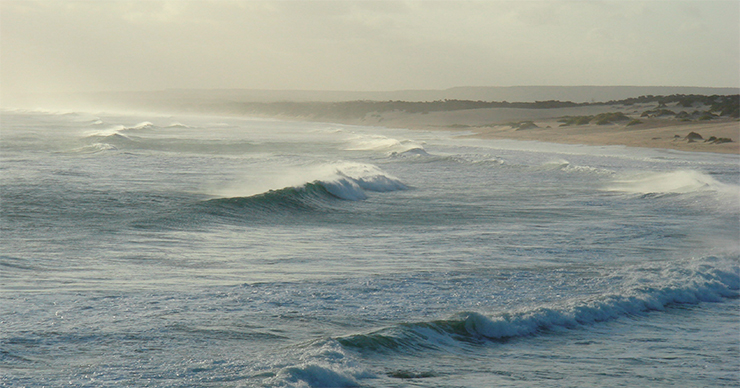
The detailed analysis of the mentions of meteorological and geophysical phenomena in ancient legends and texts allowed Masse not only to put forward a hypothesis about the cosmogenic nature of the planetary catastrophe caused by a giant comet falling into the ocean but also to identify the approximate site of the fall, i.e., the southwestern part of the Indian Ocean, not far from Madagascar.
A monumental impact destroyed the underlying rocks of the Earth’s crust, throwing billions of tons of rocks into the atmosphere. Soon after, those rocks began to fall down to the surface in the form of molten rock particles, causing fires in the African and South American savannahs. The blast also caused a devastating tsunami, which wreaked havoc on the nearby shores of the Indian Ocean. Most importantly, the blast evaporated and lifted into the atmosphere huge masses of water, and within a day, that water began to fall onto the Earth in the form of continuous torrential rain, transforming lowlands everywhere, on all the continents, into lakes, and only the tops of mountains and high hills could rise above water. Then hurricanes joined the process, carrying away, with strong winds and torrential rains, the excess of thermal energy thrown into the atmosphere from the impact area of the cosmic body.

Masse’s hypothesis gave impetus to a targeted search for craters on the bottom of the Indian Ocean. A year later, another member of our group, the marine geologist Dr. D. Abbott from the Lamont-Docherty Geological Observatory (United States) discovered by analyzing bathymetric maps a ring structure with a diameter of 29 km, which she named the Burckle crater. It is located at a depth of about 4.5 km and is almost bare of bottom sediments, which indicates its relatively young age.
Abbott studied drilling samples from the bottom near the crater, which were obtained as part of the international Deep Sea Drilling Project (DSDP), and found several pieces of direct evidence of its possible impact genesis: traces of ejection of deep seated rocks in the uppermost part of the section, crushed grains of other minerals (feldspar, spinel), and micrograins of pure nickel.
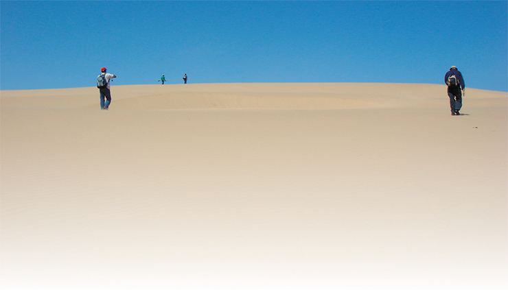
The land that lies closest to the Burckle crater is Madagascar, an island whose southern coast hosts one of the largest systems of chevron dunes seen in satellite images. The dunes stretch inland as far as 45 km, rising as high as 200 m at their edges. Moreover, the azimuth of the long axis of these features points directly to the crater.
Two competing hypotheses have been proposed to explain the formation of the coastal chevron dunes: the wind hypothesis and the water hypothesis. Neither of them can be confirmed or refuted by satellite images alone. In 2006, we were able to study three of the four systems, including the two largest ones in the area of the Fenambosy and Ampalaza Bays. The very first field routes showed that the dunes are composed of coarse-grained unsorted sea sand and they include pebbles and debris that cannot be moved by the wind.
 resemble closely the giant chevron dunes in the south of Madagascar. Photo: members of the 2012 expedition to Groote Eylandt. Left to right: D. Abbott, B. Masse, D. Masse, V. Gusiakov")
Shells and coral remains found in the dune sand also testify to the marine origin of the material. Numerous marine microfossils are also found in the sand in the form of tiny fossilized foraminiferal shells. Noteworthy is the fact that the fine structure of the shells turns out to be almost intact, which would have been impossible if they had been transported by the wind over a distance of dozens of kilometers.
“The Sun became dim for nearly a whole year…”
The most recent global climate catastrophe occurred in 536–540 AD. This time interval first attracted the attention of dendrochronologists in the 1970s as they were putting together a master chronology for anomalies in European oak wood rings over two thousand years. Subsequently, when they obtained similar long series for other continents, it became clear that the anomaly was global in its scale. An analysis of borehole logs from glaciers in Greenland and Antarctica showed that ice in the corresponding time interval contains very high concentrations of ammonium and chlorine, possible evidence of large-scale fires and widespread acid rains.
") Factually, this period was one of the turning points in world history, i. e., the transition from the ancient world to the modern one. It was an unprecedented catastrophe in the entire period of written history. Suddenly, for no apparent reason, “the Sun became dim for nearly a whole year” (Keys, 1999). Weather conditions all around the globe changed dramatically. Some countries were hit by droughts; others, by floods. Crop failures in Asia and the Middle East brought many ancient cultures to the brink of collapse. An epidemic of bubonic plague, which began in Africa, wiped out half of the European population. Within a few decades, the old world collapsed to be replaced by a new world, the one we know today (Keys, 1999).
Factually, this period was one of the turning points in world history, i. e., the transition from the ancient world to the modern one. It was an unprecedented catastrophe in the entire period of written history. Suddenly, for no apparent reason, “the Sun became dim for nearly a whole year” (Keys, 1999). Weather conditions all around the globe changed dramatically. Some countries were hit by droughts; others, by floods. Crop failures in Asia and the Middle East brought many ancient cultures to the brink of collapse. An epidemic of bubonic plague, which began in Africa, wiped out half of the European population. Within a few decades, the old world collapsed to be replaced by a new world, the one we know today (Keys, 1999).
When looking into the causes of the catastrophe, suspicion fell at first on the eruption of a large volcano located in the equatorial belt. However, volcanologists could not point to any particular volcano that could have erupted during that period. An analysis of bottom sedimentary columns from the various regions of the World Ocean did not reveal any volcanic ash layers either, which should have inevitably been there after such a massive eruption.
A step towards unraveling the causes of this climate catastrophe was made in 2005 by the same Dr. Abbott from the Lamont-Doherty Geological Observatory. When studying bathymetric maps of the Gulf of Carpentaria in northern Australia, she found two circular depressions – Kanmare and Tabban (9 and 12 km in diameter, respectively) – and suggested that these features could, in fact, be traces of a double comet strike in the southeastern part of the bay. By analyzing the top parts of borehole logs, Abbott was able to identify features characteristic of high-speed interactions, including high concentrations of iron, nickel, and chromium.
A massive impact onto the water surface, even in a relatively shallow bay, must have caused tsunami-like waves, traces of which could have remained on its shores. Satellite images of the nearest islands and the west coast of the bay did reveal the presence of chevron dunes, which are, according to one hypothesis, the result of deposits of powerful water flows.
In 2012, we managed to visit one site on the east coast of Groote Eylandt, a place with the most developed dunes. It was difficult to conduct fieldworks there because the island is controlled by native tribes, and most of its territory is closed even to Australians. After arduous negotiations with the tribes, we managed to get permission to visit the coast, where we saw roughly the same picture as in the giant dunes of Madagascar, i.e., unsorted sea sand with inclusions of coral fragments and pebble material, which by no means could have been carried so far away from the shore by wind. Nevertheless, a conclusive answer to the question about the causes of the global climate catastrophe of 536–540 AD would require large-scale interdisciplinary research on all continents.
“Earth in the cosmic shooting gallery”
All that said how real is the threat from the cosmos? Despite its immense vastness, incomprehensible to an ordinary human mind, the cosmic space is by no means empty. Within the Solar System and in its immediate vicinity, there are multitudes of cosmic bodies apart from the Sun and planets and their satellites, of very different composition and size, ranging from micron-sized particles of cosmic dust to large asteroids and giant ice comets.
All these bodies interact with one another through their gravitational fields, and sometimes directly, through collisions. The formation of craters is one of the main processes shaping the surface of even large asteroids. It is no coincidence that one of the most cited works on this subject, written by British astrophysicists, is called Earth in the Cosmic Shooting Gallery (Asher et al., 2005).
Shooting never stops in this gallery, not for a day. Everyone must have seen, many times, meteor trails in the night sky, left by microparticles burning in the upper layers of the stratosphere. From time to time, larger objects fall onto the Earth. These bodies explode at altitudes of 15–20 km; the bright fireballs show up even in the daytime sky, and the shock wave can reach the Earth’s surface. The last such event, widely known, was the explosion of the Chelyabinsk meteorite on February 15, 2013, whose TNT equivalent is estimated at 450–500 kt.
 ejected by an explosion from a depth of about 40 m, which can serve as evidence of the lake’s impact origin. Photo by the author")
The Chelyabinsk explosion, which created a state of shock not only in the immediate eyewitnesses but also in the local authorities, was qualified as a nationwide emergency. Media, as well as some scientific publications, presented the fireball as a completely exceptional and extremely unlikely event, the closest analogue being the Tunguska catastrophe of 1908. However, a cosmic body only slightly smaller than that, with a TNT equivalent of about 170 kt, hit the Earth only five years later – fortunately, it exploded over a desolate part of the western Bering Sea.
As mentioned above, the minimum size of an asteroid capable of causing a global climate catastrophe with the most serious consequences for civilization is 1 km in diameter, and the TNT equivalent of its explosion is 50–70 Gt. This quantity is roughly two orders of magnitude greater than the total stock of warheads in all nuclear countries. Climate changes ensuing from an instantaneous injection of this amount of energy into the Earth’s atmosphere will be so dramatic that not a single state, even if unaffected directly by the impact explosion (by light radiation, shock wave, earthquake, or clouds of ash and dust), will be able to cope with them.
Today, the number of kilometer-sized bodies (one kilometer or more in diameter) in the asteroid belt is estimated at about a thousand; it is believed that more than 90% of asteroids of this class have already been discovered. Currently, there are no objects on a trajectory of a dangerous approach to the Earth in the next 50–100 years.
On the vast territory of Siberia and the Far East, there are 11 confirmed and about 60 alleged impact structures, including the 100-kilometer Popigai crater, one of the largest on the Earth. In recent decades alone, two large fireball explosions were recorded in Siberia: the Chulym (February 26, 1984) and Vitim (September 25, 2002) events with a TNT equivalent of at least 10 Kt.
Siberia was also hit by the strongest bolide impact among those reliably documented, i. e., the Tunguska explosion on June 30, 1908, with a TNT equivalent of 5–10 Mt by modern estimates
Cosmic bodies in the subkilometer range (140–1000 m) are, however, many tens of thousands in number; a full detection of these bodies will take decades of continuous observation. It is bodies from this category that appear, now and again, in the media as hazardous objects threatening to collide with the Earth. They include, e.g., the famous asteroid Apophis with a diameter of 340 m, which is expected to make a close approach to the Earth (less than 0.1 distance to the Moon) in 2029 and, possibly, again in 2036. If such an asteroid hits the Earth, the TNT equivalent of the explosion will be more than 500 Mt.
The history of global climate catastrophes in the Holocene shows that the threat of cosmic body impacts on the Earth deserves attention. While the majority of the astronomical community dismisses the possibility of cosmogenic causes of these catastrophes, geologists point to the existence of at least a dozen young craters and several crater fields formed during this period. The largest craters are Macha in Yakutia, Henbury in Australia, Kaali and Ilumetsa in Estonia, Morasko in Poland, Umm al-Binni in Iraq, Wabar in Saudi Arabia; and the crater fields are Campo del Cielo and Rio Cuarto in Argentina and Chiemgau in the Bavarian Alps.
Moreover, many peculiar ring structures are awaiting confirmation of their impact origin, including circular lakes, which are exceptionally deep (up to 50–70 m) for water bodies located on lowlands and have an edge rim on their shores. Several such lakes exist in Central Russia alone, and limnologists cannot explain their origin. The most studied one is Lake Smerdyache, 90 km east of Moscow, perfectly round, about 400 m in diameter and up to 36 m deep. The lower limit of explosion power required to create such a funnel in sedimentary strata is about 1 Mt in TNT equivalent.
")
Studies of deep lakes like this one, as well as analyses of evidence of large fireball explosions such as Chelyabinsk or Tunguska, are extremely important since they help refine the frequency of cosmic body impacts on the Earth during the present stage in its geological history. Conventional estimates for this frequency, based on an analysis of the catalogue of impact craters on the Earth and other planets, are less reliable because their temporal coverage is too large, i. e., two billion years for the Earth, and on such long time intervals, this frequency may vary for purely astrophysical reasons. In turn, reliable estimates for the frequency of impact events are necessary in order to compare the actual risks of the various natural hazards.
Impacts of cosmic bodies on the Earth are natural catastrophes with a low probability yet potentially severe consequences. Currently, we have no effective system for protecting the Earth from space threats (and unlikely will in the near future); therefore, the only countermeasure is an action plan to reduce the severity of the consequences. And such a plan should rely on the results of studies ofthe damaging factors, i.e., the consequences of the impacts on the Earth’s atmosphere and surface, and on adequate risk assessments.
References
Alvarez L., Alvarez W., Asaro F., Michel H. Extraterrestrial causes for the Cretaceous–Tertiary extinction // Science. 1980. V. 208. P. 1108.
Asher D. J., Bailey M., Emel’yanenko V., Napier W. Earth in the cosmic shooting gallery // The Observatory. 2005, V. 125. P. 319–322.
Barenbaum A. A. Galactocentric Paradigm in Geology and Astronomy, Moscow: LIBROKOM, 2010. 544 pp. [in Russian].
EDEIS (2021) Expert Database on the Earth Impact Structures, https://tsun.sscc.ru/nh/impact.php
Hildebrand A., Boynton W. Cretaceous ground zero // Natural History, 1991. V. 46.
Firestone R., West A., Warwick-Smith S. The Cycle of Cosmic Catastrophes: How a Stone-Age Comet Changed the Course of World Culture, 2006.
Kjaer K. H., Larsen N. K., Binder T., et al. A large impact crater beneath Hiawatha Glacier in northwest Greenland // Science Advances. 2018. V. 4. N. 11. DOI: 10.1126/sciadv.aar8173.
Keys D. Catastrophe: An Investigation into the Origins of the Modern World. New York: Ballantine Books, 1999. 343 pp.