Iturup Island: Following the Trace of Volcanic Catastrophes
Since times immemorial, volcanoes have been for humankind both a source of fear and superstitions and an object of worship. But they also evoked the desire to understand the essence of volcanism and learn, if not to withstand, then at least to predict catastrophic eruptions and prevent the most horrible consequences... In order to understand the mechanisms of these catastrophes, Novosibirsk researchers traveled to one of the most remote corners of our country – to the Kuril Islands – in searching for evidence of large-scale volcanic eruptions of the recent past
Scientists have no such motivation as just doing something “heroic.”
They have a completely different goal: to find and study.
Academician Nikolai Dobretsov
Volcanoes and their eruptions are diverse, like all natural phenomena. Some active volcanoes are a popular destination for tourists; others are better to stay away from.
The most furious ones are volcanoes with the so-called explosive eruptions. Volcanic explosions are a dynamic phenomenon developing at a blistering speed. In the blink of an eye, a huge amount of scorching ash, mixed with volcanic gas, shoots out from the vent and into the air. The ejection lasts for a very short time.

Ordinary explosions last a few seconds or minutes; the clouds of ash and gas thrown out during this time are spectacular, but they quickly dissipate and do not pose a big threat. If an eruption continues for several hours, then the mass of ejected material can reach hundreds of megatons. Thus, in 2019 a relatively small explosion on the Raykoke Island in the middle part of the Kuril Islands continued for 10 hours and released about 400 Mt of pyroclastic material into the air (McKee et al., 2021; Smirnov et al., 2021).
What will happen if such an eruption lasts several days or even weeks? The volume of rocks ejected to the surface will be so large that a huge depression will emerge, most often circular or elliptical in shape.
For the first time, scientists paid attention to this kind of volcanic depressions in the first half of the 19th century and called them calderas (from ‘cauldron’ in Spanish). Back then, the British scientist Charles Lyell, one of the founders of modern geology, suggested a connection between calderas and giant explosions, but it was only in 1941 that the American geologist Howell Williams described the mechanism underlying the emergence of large calderas. He proved that a caldera forms not as a result of a gigantic explosion but because of the subsidence of a block of rocks that overlaps a huge magma chamber voided by numerous explosions.

Some eruptions of caldera volcanoes caused the ejection of hundreds and even thousands of cubic kilometers of igneous material. Volcanoes with such eruptions are called supervolcanoes. One example is the Toba volcano on Sumatra in Indonesia. Its explosion 74 000 years ago threw out over the course of few days 7 million Mt of magma, which is comparable in volume to Lake Victoria in Africa (Self and Blake, 2008).
But eruptions of caldera volcanoes are a rare phenomenon. All over the recorded human history, only ten such eruptions have happened on the Earth, and at least half of them led to global climate change. Thus, the eruption of the Tambora volcano in the Sunda archipelago in 1815 caused a sharp drop in summer temperatures across Eurasia and North America. The formation of the Rinjani volcano caldera in the same region in the 13th century contributed, as some scientists say, to a sharp global decrease in temperature, which led a century later to the Little Ice Age.
In populated areas of active volcanism, caldera eruptions became gigantic catastrophes, causing the death of tens or hundreds of thousands of people, the destruction of economic infrastructure, the extinction of flora and fauna. A striking example is the formation of a caldera in place of Thira Island in the Aegean Sea, now known as the volcano of Santorini. The eruption destroyed the ancient Minoan civilization. According to Herodotus, people would not settle on the islands surrounding the sea-flooded caldera until five centuries later.

What are the causes of so powerful eruptions? What are the consequences of the colossal explosions? And where to expect the next paroxysm?
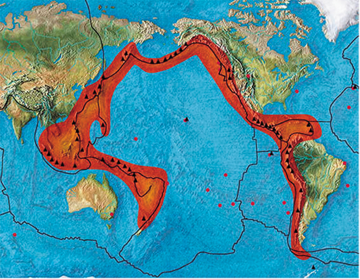
Caldera eruptions can occur in all volcanic areas located both inside lithospheric plates and on their margins. In the recent geological past, gigantic paroxysms shook the west of North and South America, i. e., the eastern part of the Pacific Ring of Fire. Powerful explosions occurred many times over the islands of the Sunda archipelago. In Russia, a large number of caldera volcanoes are located in Kamchatka and on the Kuril Islands, and some of them are still active.
Russian researchers conducted most of their studies of young calderas on the Kamchatka Peninsula. Meanwhile, the Kuril Islands – an archipelago stretching 1200 km from the southern tip of Kamchatka to Hokkaido Island – remain virtually unexplored. These islands have 21 well-defined calderas, which formed in the period from the Middle Pleistocene to the Holocene. Most of the calderas are concentrated on Iturup Island, the largest one in the Greater Kuril Chain.
Researchers of the Thermobarogeochemistry Laboratory, Sobolev Institute of Geology and Mineralogy (SB RAS, Novosibirsk), undertook a study into the causes of explosive eruptions, leading to the formation of calderas, for the Southern Kuril volcanoes. And it all started with an expedition to the Vetrovoy Isthmus on Iturup Island in 2015.
Pumice rocks
Iturup Island is one of the four islands in the chain where there are permanent settlements. The island hosts the city of Kurilsk, the administrative center of the Kuril Okrug. The city is the starting point wherefrom the expedition team sets out for its destination. Although there are roads near the city and other settlements, they do not lead where geologists need to go. So we have to reach out to local residents about hiring a car, all-terrain vehicle, or motor boat.

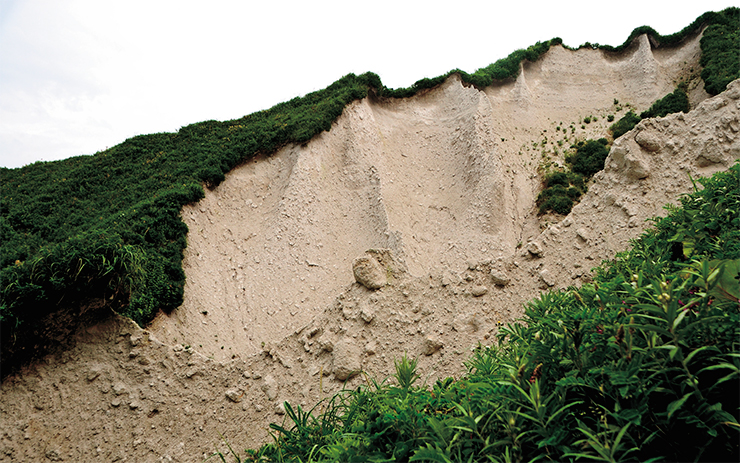
One of the most important geological objects on Iturup and, perhaps, the most mysterious one is the pumice tuffs of the Vetrovoy Isthmus. Tuffs are the product of a giant volcanic explosion or a series of explosions, which turn viscous magma into a foam. Flying out of the vents, the foam instantly hardens and turns into porous pumice. The explosion of the Vetrovoy volcano occurred 20,000 years ago, giving rise to a thick layer of pumice tuffs. About 60 % of the volume of Vetrovoy’s pumice is bubbles and empty space, which makes them so lightweight that they can float in water.
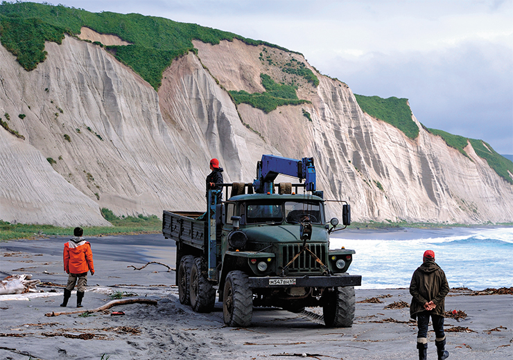
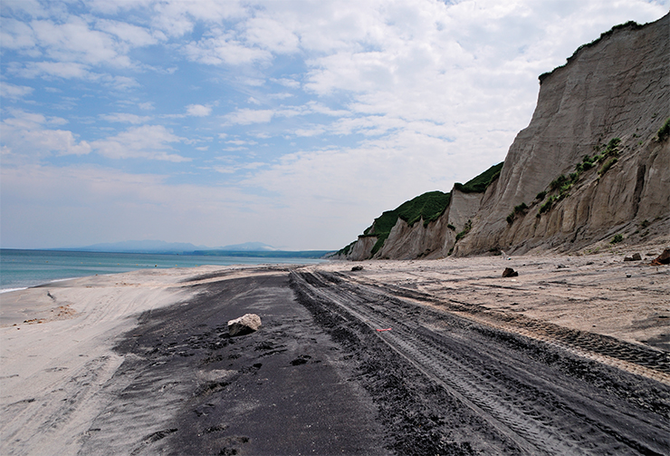
 The tuff outcrops 15 km away from the village of Reidovo are an attraction of pilgrimage for tourists from all over the world. They are called the White Cliffs. Winds and rains, these natural sculptors, carved in these rocks a lace of gorges, amazing in their subtlety and grace. The whiteness of the rocks contrasts with the black beaches stretching out at their foot.
These beaches are not only a fascinating natural phenomenon but also a deposit of ores rich in iron, titanium, and vanadium. For thousands of years, breaking waves had been grinding the white pumice stones into dust, and the sea had been carrying away the light grains into its depths. However, the white pumice contains magnetite, a black heavy mineral, and even the strongest storm cannot drag it to the sea depths. So this mineral accumulates on the beaches.
When admiring the beauty of the White Cliffs, one should not forget that the Kuril nature abounds in surprises and real danger. The magnificent beaches along the rocks are the only road connecting Reidovo and Kurilsk with the Vetrovoy Isthmus. In quiet weather, this road is akin to the best asphalt highways, but quiet weather is a rare thing on the islands.

At high tide, with a stormy western wind, ragged billows of the Sea of Okhotsk roll furiously onto the beaches, swinging at the white cliffs. In such conditions, driving along this road would require exceptional skill and courage. Many stalled 6x6 heavy trucks were dragged by raging waves into the sea, and lucky were those people who managed to get out of the vehicles in time. For this reason, car owners are reluctant to take a long-distance ride yet we need just such.
Finally, a daredevil driver is found, and the terms are agreed upon. We set out on our path. The weather is good. The driver correctly estimates the time to pass the most dangerous spots at low tide. Now the truck is driving past the magnificent white cliffs with lacy gorges. But we are not so much admiring the view but rather trying to examine the petrography of the pumice layer as we are driving past it.
 is very porous and can easily float in water")
In the vertical wall we see a layer of pumice blocks up to half a meter in diameter. During an eruption such pieces do not fly high up into the air and far away far from the vent. So the eruption must have occurred somewhere nearby, throwing out a huge amount of foamed magma over a short period of time. During such eruptions, the mass flow rate of magmatic foam and other fragments from the vent can reach from hundreds of tons to tens of megatons per second (Self and Blake, 2008; McKee et al., 2021). But here lies the mystery of the Vetrovoy Isthmus as no one knows yet where the vents were and what the caldera’s outlines are.
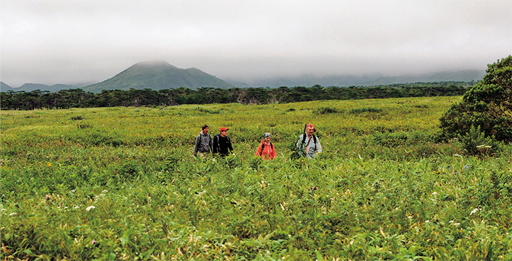
Blooming meadows of the Vetrovoy Isthmus
Having driven about 22 km from Reidovo and passed the White Cliffs, the truck turns to the Vetrovoy Isthmus. This is the lowest place on the island, where nothing prevents the winds blowing from the Pacific Ocean to the north and from the Sea of Okhotsk to the south. Hence the name given to the isthmus in the 1950s, derived from the Russian word veter, which means ‘wind’.
Furthermore, fogs are constantly going through the isthmus, so this place is humid and overgrown with lush meadow vegetation. Grasses here grow as tall as humans. Closer to the mountains, meadows give way to absolutely impenetrable thickets of birch and dwarf alder, the main obstacle to a detailed study of the deposits of the catastrophic eruption.
, only three years later by means of all-terrain vehicles (bottom)")
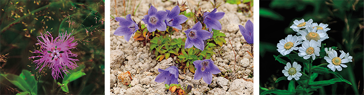
The pearl of the isthmus is the gently sloping Ruchar valley, which cuts through the pumice deposits in the northwestern part of the isthmus. Here, too, the high humidity gives birth to the diversity of the plant world. Botanists are sure to be no less fascinated by the Vetrovoy Isthmus than geologists. Summer is short on the Kuril Islands, and almost all this time, the lush meadows of the isthmus and the Ruchar valley are blooming with flowers of marvelous beauty: orange, red, yellow, blue, white… Sarankas, wild roses, lilies, carnations, and many others, the ones we do not know.
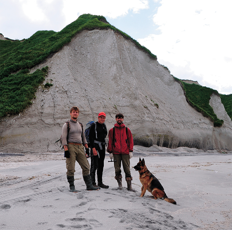
“A flowerbed indeed,” flashes through your mind when you look at all this splendor. Apparently, this is why geologists gave the name Klumba (‘flowerbed’ in Russian) to a small stratovolcano in the middle of the isthmus, the volcano whose formation marked the end of active volcanism in this area. This is also an interesting object for us. But our attempt to reach it by foot, which we will make later from the side of the Pacific Ocean, will end in a failure. Having walked 20 km, we will return to our tents, sad and disappointed.

It is only three years later, when we obtain an all-terrain vehicle, that we will break through the impenetrable alder thickets and finally explore the volcanic cone in the middle of the flowering meadows of the Vetrovoy Isthmus. During this journey, we will also see the quiet and transparent Lake Tainoye (‘Mystery Lake’), which occupies one of the late volcanic vents that threw out the last portions of pumice several thousand years ago.
In the meantime, we are heading to the coast of the Pacific Ocean, where we will set up a temporary camp near Cape Konakov and lay out routes to study the pumice layer sections. Here the pumice reaches its maximum thickness, which allows a detailed study of the ancient eruption.
“House” by the ocean
Silence broods over the isthmus, being cut only by the roaring engine of our truck. Even the wind, so common in these places, does not make any noise – the coastal dunes are protecting from it. But then the truck gets past their line and drives down to the Pacific coast. Despite the virtually windless calm, the ocean roars. Huge billows are rolling onto the shore to break into snow-white foam with walloping sounds. While the tide is low, the truck can easily drive along the beach to a place that is shielded from waves and wind by the rocky Cape of Konakov. Here, above the tidal zone, we will set up our tents on the meadow grass.
The driver hurries us to unload because the weather can change at any moment, and he wants to pass the dangerous places on the coast before the tide. We are left alone in the company of the roaring Pacific Ocean, low shaggy clouds, and white pumice cliffs – the silent witnesses of the recent geological catastrophe.

Powerful explosive eruptions throw into the air and onto the Earth’s surface a huge amount of rocks and solidified magma fragments, often transformed into debris or crushed into fine dust. The thus formed deposits are called pyroclastic, or volcaniclastic. They form layers on the surface that cover the mountains and valleys around the volcanic center.
The most important thing in any expedition is to set up a camp. This means to build a house whose walls would protect you from bad weather and wild animals and help you get warm and dry after hard routes. A tiny island where any little item of convenience becomes a manifestation of coziness.But the expedition house is a group of tents made of thin fabric and of metal and plastic tubes; these materials cannot withstand a heavy attack of the natural elements. Therefore, when setting up a camp, you need to consider both the possible directions of hurricane winds and the chances of flooding with overflow waters and storm waves. When set up properly, tents are a symbol of safety and confidence in the success of the mission.
The final touch in setting up a camp is to make a fire. The sea throws ashore everything that is washed away from ships and shores by storms: logs, boards, trunks of broken trees. The wind and sun dry them up, turning into an excellent fuel. First, you take thin twigs, then thicker sticks, and only after that the large trunks and butt logs, and just like that you have a fire. The house is ready, and we are making plans for future work
The volume of erupted material that formed the tuffs of the Vetrovoy Isthmus is estimated at 100 km3. This event was one of the most powerful eruptions that occurred on the Kuril Islands in the Quaternary period, i. e., over the past 2.5 million years. Our task is to determine the composition of the magma in the magma chamber and examine the reasons for its high explosivity (the ability to produce powerful explosions).
Obviously, before the eruption, the chamber was something like a huge bomb. But what explosive substance was contained in it? What was the fuse like? And what set off the bomb? The answers to these and other questions can be obtained by studying the pumice and the minerals it is composed of.
The strata of pyroclastic rocks allow us to reconstruct the composition of the volcanic chamber. The upper part of the chamber is represented by the pumice lying at the very bottom of the section, and vice versa. Thus, by taking samples from the bottom up along the section, we study the structure of the volcanic chamber before the eruption. Was it homogeneous? Or did it contain magmas of different composition, and if so, how were they located in the chamber? We also want to know whether there were interruptions in the formation of the pyroclastic stratum, so we need to look for interlayers of soils or products of pyroclastics erosion by rivers and streams.
Now the tasks are set, so we begin.
Tracking the eruption
We are walking up the narrow steep-walled gorges washed by streams in the pumice layer. In order to climb from the lower layers to the upper ones, we need either to climb a steep slope either directly at the mouth or in the upper reaches of the stream.
We choose the second option as less time-consuming and dangerous. Walking up the stream bed is easy enough, but we should always be wary of meeting the owner of these places – the brown bear. There are many berries on the slopes of the gorges, and berries are bears’ favorite delicacy, so we do not wish to disturb them during their meal. While walking, we try to make as much noise as possible. If a bear hears the approach of humans in advance, it will most likely rush away.
We are walking up between the steep cliffs, carefully studying the composition of the tuffs exposed near the stream bed. The bed gradually rises, so we are moving up the section. In the upper reaches, the slopes are slightly smoother, and we can climb up, clinging to the grass and bushes. Where the grass does not cover the rocks, we take samples of pumice. From our camping site, we can only reach a height of about 150 m above sea level – higher up there are either steep cliffs or impenetrable thickets. But we have managed to explore more than a half of the visible section.
It immediately becomes clear that all the layers formed almost simultaneously. We are beginning to see the picture of a real catastrophe. A hail of gigantic explosions is throwing colossal amounts of ash and pumice into the air. The sky disappears behind dense clouds of ash; avalanches of red-hot pyroclastic pumice flows are rolling over the surface. Hot ash surges are dashing ahead at a great speed, sweeping everything on the way. And all this is happening in total darkness, cut by flashes of lightning. It is obvious that after such a cataclysm, the land around the modern Vetrovoy Isthmus turned into a desert for hundreds, perhaps, even thousands of years, and Pacific typhoons were rushing tornadoes of volcanic sand across the dead land.
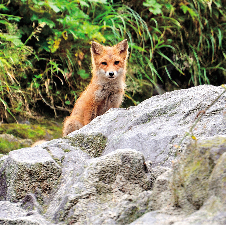
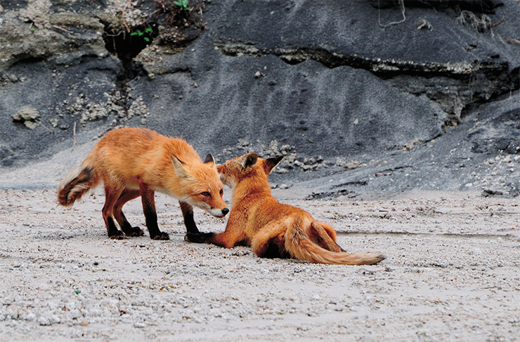
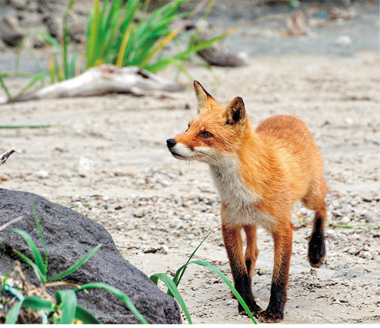
…Despite the incessant roar of the ocean and the stormy waves, we are lucky with the weather. There are neither rains nor hurricane winds; fogs and light drizzle do not count. Bears do not bother us either. Only a family of foxes is circling around the camp, but they are watching us respectfully from afar.
Finally, the work is done; the samples are collected and packaged. Now our goal is to get back to our research laboratories at the institute, where we could start unraveling the mysterious processes that took place in the volcanic chamber before the catastrophe.
At the appointed hour, the familiar truck is driving hurriedly towards us along the coast opened by the ebb. Again, urged by the edgy driver, we quickly throw our backpacks, heavy from stones, into the back of the truck and jump up ourselves. Only now, as we are driving, we can send our farewells to the white cliffs and stern rocks of Cape Konakov, which so carefully sheltered us from the waves and wind, and say goodbye to the roaring Pacific Ocean.
We will return here in three years to test the hypotheses we have put forth. To make sure some are valid and others are not.
Invisible witnesses
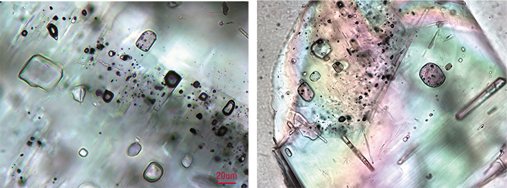
Even in ancient times, learned people noticed that inclusions in crystals carry information about the history of their formation. At first these inclusions were used as a means of determining the authenticity of precious stones. Later, with the advent of first optical and then electron microscopes, it became possible to reconstruct the conditions under which minerals are formed in the bowels of the Earth, inaccessible to direct observation. We also used the tiny inclusions, often invisible to the naked eye, to decipher the events that preceded the catastrophe on Iturup Island.

A growing crystal captures, in addition to other minerals, tiniest droplets of the melts and fluids (gaseous components of magma or gas-enriched liquid solutions) from which it is formed. This fact is very important because when studying rocks, direct information about the substance from which minerals are formed usually disappears. Melts turn into associations of minerals, and fluids escape through pores and cracks to dissipate in the depths. It is only the tiny inclusions captured by minerals that preserve this seemingly lost information.
We extracted the minerals contained in the pumice samples; these minerals had been growing in the magma of the volcanic chamber immediately before the start of the eruption. The inclusions of melts and fluids helped to determine the temperatures and pressures as well as patterns of change in the chemical composition of these substances.
It turned out that the eruption was associated with a huge chamber of magma composed of various minerals and a melt that was more than 70 % silica (silicon dioxide, SiO2). These melts, which geologists call felsic, have a very high viscosity. So high that, e. g., they split when being hit, instead of splattering like a normal liquid. But in the Earth’s crust, these melts can move only if they are heated to high temperatures or if they contain volatile components, which thin out the melts. It is these volatiles that are deemed responsible for the high explosivity of felsic magma eruptions.
It is known that if volatile components are contained in liquid, easily flowing melts, their release leads to the formation of fluids in the form of buoyant bubbles. These bubbles rise along with the magma through the volcanic conduits and either burst on the surface of lava lakes or escape form the melts through pores and cracks into the wall rocks to appear on the surface as part of fumarole gases.
A completely different picture arises in the case of an felsic melt. Its high viscosity prevents bubbles from rising, so they cannot escape from the melt and create very high pressure in it. The magma begins to press on the overlying rocks, which causes the surface to rise and form cracks, through which the viscous and light magma rises to the surface (see diagrams on pp. 24–25).
As the magma rises, the rocks’ pressure decreases, and the bubbles in the magma begin to grow rapidly, gradually coalescing and transforming the melt into foam. The foam expands the cracks and rushes up to the surface even faster. As soon as the crack reaches the surface of the volcano, the formation and growth of bubbles in the foam becomes rampant, and the first explosion breaks out. It destroys the rocks around the fissure and further reduces the pressure of the wall rocks onto the magma. Gas bubbles begin to form and grow not only in the crack but also in the deeper parts of the chamber, reducing the density of the magma and increasing its mobility.
This mixture easily seeps into other cracks and, expanding them, comes out on the surface, giving rise to more and more explosions. The numerous cracks release a huge amount of foaming magma, which breaks out to the surface with tremendous force, destroying everything in its path. The rocks covering the chamber, which is now freed from magma, fall down, squeezing out additional portions of magma through newly formed cracks (see diagrams on pp. 24–25).
This is what volcanologists think about the development of eruptions that give rise to calderas.
The Iturup samples provided evidence of the possible presence of fluid bubbles in the magma of the volcanic chamber. Released from magma, fluids behave like gas and tend to increase in volume, but given a lack of space, they contribute to the growth of pressure in the chamber. But in this event, the release of fluids itself did not cause the explosions, a conclusion we made by studying the mineral plagioclase.
 Unlike the other minerals birthed by magma from the Vetrovoy Isthmus, plagioclase has a zonal structure, with each zone corresponding to a certain time of crystal growth. By studying the composition and outlines of the growth zones, we can find out the patterns of change in temperature, pressure, and the composition of the parent melt from which plagioclase was growing. If the release of fluid had led to an explosion and to the emptying of the chamber, the growth of this mineral would have ceased. However, it continued even after the release of fluid had finished.
The catastrophic explosion appears to have been triggered by an accumulation of released magmatic fluids, which had failed to escape the chamber. Again, it was the tiny recluses – the inclusions in the minerals – that enabled us to clarify the possibility of such a scenario.
Plagioclase contains inclusions of glassy melt droplets and bubbles of magmatic fluids. Modern methods of microanalysis are capable of determining the exact content of almost all chemical elements in a virtually point-like sample volume, i. e., 10–8–10–9 mm3. Using this latest technique, we showed with certainty that the bubbles and glass droplets contain water.
It turned out that the magmatic melt in different parts of the chamber contained from 3 to 6 wt. % water, and the released fluids consisted of 98 % water and had a density of 0.22 g/cm3 (Smirnov et al., 2019). Based on these data, we could estimate the pressure at the time when the fluids were released from the magma, and the result should be close to the pressure of the overlying rocks, which “restrain” the magma’s explosive energy.
This indicator turned out to be approximately 1000 atmospheres, from which it follows that the ready-to-erupt part of the magma chamber was located at a depth of about 3 km beneath the Earth’s surface. However, theoretical models for the dissolution water in magmas tell us that at such depths, the melt should contain much less water than we found. This phenomenon can only be explained by the fact that either in the whole chamber or in its individual sections, the pressure of the magma exceeded that of the overlying rocks. By a factor of 2–3, according to our calculations.
Scenario of the catastrophe
From the foregoing, the following scenario emerges for the eruption. Magma, saturated with water vapor and other gases, accumulates in the upper parts of the chamber. The release of fluid bubbles begins in the magma. Its density decreases, and its viscosity, too, decreases slightly, which contributes to increasing pressure onto the hard rocks overlaying the chamber (onto the roof). The release of magmatic fluid bubbles and their isolation inside the still sufficiently viscous magma has cocked the explosion mechanism – it remains only to pull the trigger.
, and finale of the eruption in the graben of the Vetrovoy Isthmus, which ended in a catastrophic explosion and the formation of a caldera (right)")
It so happened that the source of the eruption had formed in the marginal part a graben, i. e., a depressed block of the crust of the island arc. Grabens are limited by faults, along which the block moved downward. The faults are crustal areas where strength is weaker to allow for tectonic movements of blocks relative to one another. The faults trace their roots into the inaccessible bowels of the Earth; deep magmas and fluids rise along them to the surface. The thickest part of the pumice tuffs on the Vetrovoy Isthmus projects itself onto the zone of one of these faults. This fact gives grounds to believe that it was the movement along this fault that activated the “fuse.”
The catastrophe, some details of which became clear during our field work, broke out on the shore of a shallow sea strait separating small islands that later became part of the modern Iturup Island. Hot pyroclastic flows almost completely filled the strait, and it became very shallow; however, the rise of the sea level after the end of the Ice Age allowed it to exist for another 18,000 years. But either tectonics or a subsequent uplift of the surface, typical of very powerful eruptions, completely drained the strait.
The last explosive eruptions on the isthmus took place about 2000 years ago, but their strength and scale were no longer as impressive as the main episode in the formation of the pumice tuffs. Volcanic activity gradually faded. One of the most recent episodes is the emergence of Klumba, a small stratovolcano.
This volcano was born by magmas with a low content of silicon oxide (i. e., not felsic but basic). Such magmas originate deep in the mantle and are denser and less viscous than the parent pumice magmas. A large chamber of light and relatively cold felsic magma, which had existed before the catastrophic eruption, had prevented the rise to the surface of the hot and heavy basic magmas that gave rise to Klumba. But they had been feeding the chamber of the catastrophic eruption with heat and fluids released from them, also contributing to the increased mobility of the magmas in the chamber.
It was only after the emptying of the chamber that the heavy basic magmas were able to reach the surface and form their own volcano. This episode marked the end in the volcanic history of the Vetrovoy Isthmus, a history that began with a colossal explosion that shattered this Kuril region 20,000 years ago.
When the catastrophic eruption broke out in the place of the future Iturup Island, the expanses of Eurasia and North America were shivering from the bitter frosts of the last Ice Age. Primitive people were migrating across the land bridge of Beringia, connecting Siberia and Alaska, in search of a better life. But many years were yet to elapse until the primitive man would begin to settle consistently on the Kuril Islands.
We believe that that natural catastrophe did not impact humans. At least, the age of the most ancient settlements on Iturup is 8000–10,000 years. But it is obvious that the animal and plant world in this part of the archipelago suffered to the fullest from the deathly breath of the volcano.
The catastrophic eruption became one of those events that led subsequently to the formation of the largest island in the Kuril group. And geologists are still asking a lot of questions and pondering over unsolved mysteries of this wild yet fascinating region of the Earth.
References
McKee K., Smith C. M., Reath K. et al. Evaluating the State-of-the-Art in Remote Volcanic Eruption Characterization Part I: Raikoke Volcano, Kuril Islands // J. Volcanol. Geotherm. Res. 2021. V. 419. 107354.
Self S., Blake S. Consequences of Explosive Supereruptions // Elements. 2008. V. 4. P. 41–46.
Smirnov S. Z., Nizametdinov I. R., Timina T. Yu. et al. High explosivity of the June 21, 2019 eruption of Raikoke volcano (Central Kuril Islands); mineralogical and petrological constraints on the pyroclastic materials // J. Volcanol. Geotherm. Res. 2021. V. 418. 107346.
Smirnov S. Z., Rybin A. V., Kruk N. N. et al. Parental Melts and Magma Storage of a Large-volume Dacite Eruption at Vetrovoy Isthmus (Iturup Island, Southern Kuril Islands): Insights into the Genesis of Subduction-zone Dacites // J. Petrol. 2019. V. 60(7). P. 1349–1370.
Members of the expeditions: researches of the Institute of Geology and Mineralogy, Siberian Branch, Russian Academy of Sciences, Candidates of Science (Geo.–Min.): D. V. Kuzmin, T. Yu. Timina, and A. Ya. Shevko; graduate and postgraduate students of Novosibirsk State University: I. R. Nizametdinov, I. A. Maksimovich, and A. A. Kotov.
The author thanks Cand. Sci. (Geol.–Mineral.) A. V. Rybin, Head of the Laboratory for Volcanism and Volcanic Hazard, Institute of Marine Geology and Geophysics, Far Eastern Branch, Russian Academy of Sciences (Yuzhno-Sakhalinsk), for support in research and expedition work
This work was supported by the Russian Foundation for Basic Research (project nos. 18-05-00819 and 16-05-00894) and by the Russian Science Foundation (project no. 20-17-00075)