Mission Possible: to Hear the Breath of Ebeko
Installing a network of seismic stations on an active volcano is not the same as putting spots on a map on the basis of scientific appropriateness. It rather resembles James Bond adventures that befell the scientists from Novosibirsk on Paramushir, the northernmost of the Kuril Islands, where Ebeko Volcano is located. A whole year 21 seismic stations will record the volcano's pulse. These data will enable the scientists to look into the volcano's structure and to see how it works.
We are giving floor to the participants of the expedition, who will tell the readers about the importance of this research and the difficulties they had
Paramushir, the second largest island of the Greater Kuril Chain, has a few active volcanoes, the most active of which is Ebeko: since 2016, it has been periodically blasting ash and gas clouds, on some days, with a less than hour gaps between blasts. The explosion itself, lasting a few minutes, is followed by a relatively calm gas release.

Ebeko is situated only 6 kilometers away from the town of Severo-Kurilsk with a population of 2,500. Understandably, its activity raises serious concerns and makes the local residents feel uncomfortable. When the wind blows from the volcano toward the town, all open surfaces are covered with ash, which results in fast equipment wearing and malfunctioning. Sometimes, the unpleasant smell of volcanic gas is felt in the air.
It has been believed until recently that the emissions from Ebeko consist entirely of gas and ash. Such phreatic eruptions occur because the so-called meteoric waters (originating from rains or melting snows) circulating under the volcano’s surface are heated by the rising magma, boil, and rapidly transforms into a vapor. Observations over similar volcanoes in the world have shown that this kind of volcanic activity is unlikely to result in a large eruption with disastrous consequences for the island’s population.

However, some recent research has clearly shown the traces of igneous material in Ebeko’s volcanic ash (Belousov et al., 2021). It means that we cannot rule out the scenario when deep fluids – liquid and gaseous highly mobile substances dissolved in magmatic melts or present there in the form of bubbles – come into play. If their concentration increases when the temperature and pressure approach their critical values, avalanching degassing may develop, which is similar to foaming occurring when a bottle of champagne is opened. This process may lead to a disastrous eruption. The conclusion emerges itself: Ebeko must be studied using all available techniques of modern geology and geophysics.

Another reason urging such studies on Paramushir is potential exploration for geothermal resources for the benefit of the local population. Today, Severo-Kurilsk relies on diesel fuel for electric power, heat and hot water supplies. The purchase and delivery of this fuel costs a fortune while there is a huge volcanic «steam boiler» with its infinite power resource in the vicinity of the town. Back in the 1990s, a very expensive well, 2.5 km deep, was blindly drilled for thermal waters in proximity to the town but the attempt failed. One can still see the remains of an old drilling rig on the path leading to the volcano.
And yet there is little doubt that there are immense geothermal reservoirs underneath Ebeko and the nearby fumarole fields. The challenge is to determine how close their boundaries are to the town. Data on the deep structure of the island will allow avoiding barren drill holes in the future geothermal prospection. Moreover, the global trend to employment of alternative energy including geothermal power makes geological and geophysical research in the area of Ebeko particularly important.

Until 2021, Paramushir had only one continuously operating seismic station for monitoring of the background seismic activity. In June this year, Novosibirsk scientists from the Trofimuk Institute of Petroleum Geology and Geophysics and Sobolev Institute of Geology and Mineralogy SB RAS deployed a network of 21 seismic stations on and around Ebeko with a view to determining the geometry and physical properties of the magma chamber and studying its interaction with the deep and meteoric fluids.
Test to failure. From the expedition journal
Installing a seismic network on an active volcano is a logistical challenge. The easiest thing is to put spots on the map on the basis of scientific appropriateness. After that, adventures like in Mission Impossible or James Bond movies begin, when you have to travel on a wide variety of vehicles and, most often, on foot with a heavy backpack, climbing over blocks of lava flows or scraping through alder thickets and dwarf pine wood, using all of your physical resources.
The only inhabited locality on Paramusir is Severo-Kurilsk, surrounded by some kind of roads suitablefor motor vehicle transportation. Some destinations can be reached by four-wheel motorcycle, and those along the shoreline by motor boat but only in windless weather, which in the Northern Kuriles is very rare. For the same reason, it is risky to rely on a helicopter. As a result, the most reliable means of transportation is your own feet and backs – they can take you wherever you need on any fine day.

Scheduling a commuter helicopter that comes to the island once a week is a bunch of unknowns. You can fix the flight date but can never be sure that the weather conditions will allow you to complete the planned work.
And yet, here comes the day. The helicopter lands on the landing area on the outskirts of the town. The team load almost a ton of equipment swiftly and in unison. Wheels up. In what seems a couple of minutes, the aircraft lands on a 1,000‑meter mountain top, where the first station is to be set. In a mere 10 seconds, two people and equipment are disembarked, and the helicopter takes off this very second. We have half hour while it is delivering two other teams and equipment across the island. In this time, we have to find a site for the station, dig a hole, install the equipment and mask it. The earth is wholly unworkable – wet and stony. We carry stones till our backs ache to erect something like a sacrophagus over the seismic station. At last, we’re done. The helicopter appears this very minute.

It looks like the huge engine of MI‑8 is landing right on our heads – the wheel is just a meter away. We jump into the helicopter and fly away this very minute. Now we head for the next site to pick up our guys and fly on. Everything happens like a shot, no wasted movements. The professionalism of the helicopter crew is amazing – they are accurate to the second and centimeter.
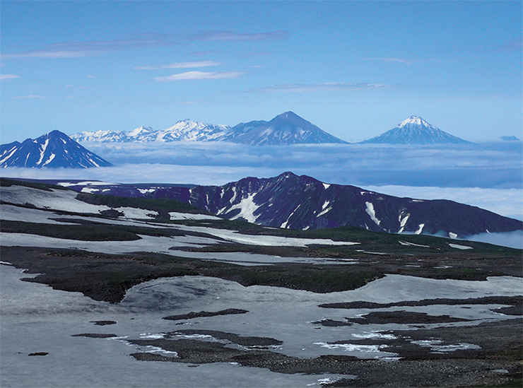
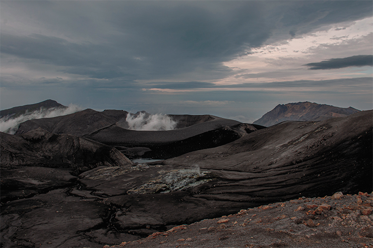
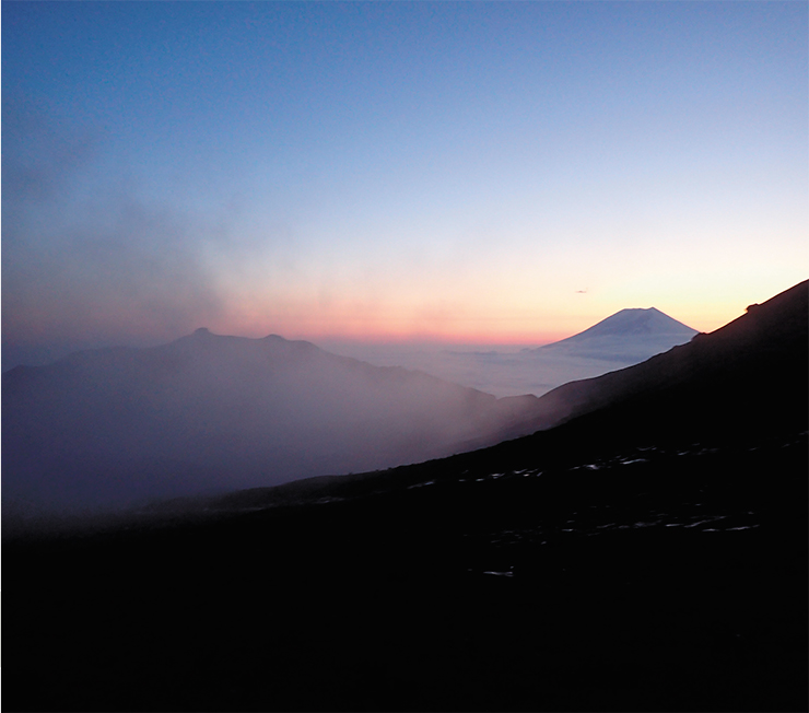
Under the pass at the crest of the volcanic ridge all of our team makes a lodgment, together with the equipment for the makeshift camp. Our flight has lasted a little over an hour. All the stations have been transported to their sites; some of them have been installed. We can relax and enjoy the splendid view. On the one hand, Alaid Volano on Atlasov Island in the rays of the setting sun, under the canopy of the clouds wrapping the Sea of Okhotsk; on the other hand, Ebeko ejecting an ash column as a salute to us. An inquisitive firefox approaches our camp and wonders about the contents of the metal pots and tents like a hostess, without any shadow of confusion. We are sitting amidst this splendor and feel a bit like hobbits. Felicità!

Morning. Everybody go to the pre-planned spots; the basic equipment is waiting for us at the sites where the stations are to be installed. The weather is lovely, and we are looking forward to a nice light walk. Having approached the spot, we see a rock towering in front of us with sheer cliffs on the top – it looked quite different from the helicopter. Nothing else to do but start the ascent. When it seems that we will not be able to climb it after all, we suddenly find ourselves at the summit, on a small flat plateau. We comfort ourselves with the idea that bears are not dumb enough to climb all the way up here to loot our station.
We are installing the equipment against a spectacular background of the erupting volcano. And look for the way back on the other side of the plateau. We slide slowly into a deep valley formed by the steep edges of lava flows and cut across by a glacier, and then climb up again. All in all, it takes three hours instead of the scheduled one.

Now we are back at the foot of the rock where we left our backpacks. We feel like lying back and forgetting about the upcoming ascent to the ridge. However, the weather is getting worse, it starts raining, and our location is beset by thick mist so we decide to go back quickly. We realize that we cannot install another station. When we have climbed to the top, we see that the wind has become stronger, the mist is swept away and our spot with the equipment is at hand. So we’ll install it after all. The station is at the rim of the southern crater of Ebeco; we can see the active funnel in the northern crater 700 meters away. Luckily, the volcano is silent now. Stormy wind, volcanic dust and sand choke our eyes, mouths and noses. We’ve done it. Exhausted, we start our descent towards the town – mission completed.
…Looks like the hardest job is done: all the stations on the Vernadsky Ridge and in the northern part of the island have been installed. What is left are a few spots on the western coast. The best approach would be to reach them by the sea but it would take long and the weather may suddenly turn nasty, which may prove critical. So we decide on walking. Two sites are in a ten-kilometer walk along the boulder shore bordered by sheer cliffs. To get to the third one, we’ll have to cross the island from the Pacific Ocean to the Sea of Okhotsk and back.
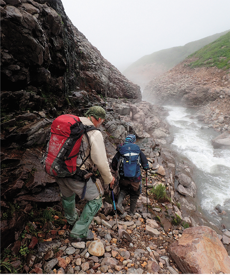

We set off at six in the morning; the weather is kind to us. We climb the pass across the Vernadsky Ridge in record time, then head down to the valley of the Yurieva River. Hot springs are everywhere in the valley, steaming the area around. The river is warm though it partly feeds by meltwaters from late-season snow fields. There is 3 km left to the Sea of Okhotsk, and we’ll have to walk along the river bed. The local residents tell us that the path alternates between the river banks, so we will have to cross it many times. Just in one spot, the river flows at the bottom of a deep canyon, where we’ll have to walk along a narrow ledge on a steep cliff.
In reality, the river is unexpectedly water-rich, so every ford has to be carefully sought and explored. The trip takes about three hours. Now we look for the hidden equipment, install the station and head back without a rest. The river has become even more furious, sometimes completely impassable. We try to go round the most dangerous gorges, climbing steep slopes. It doesn’t always work, so we look for new ways. Going along the river takes ages, you feel like dropping down and not going anywhere. It takes enormous effort to get back to the feet and walk on.

At last, we reach a flow of Ebeko lava that we have to climb, and it makes us happy. The sun is setting, and we have to get to the pass 1,000 meter high and go down. As we are climbing up, we notice the unmistakable smell of poisonous volcanic gas. Gas masks on.
The last ray of sunshine is gone. It’s difficult to walk, we are short of breath, and our throats are dry. But anyway we must wear or masks on. We need to get out of this death trap as soon as possible. Toxic gas mixes with mist. In twilight, GPS leads us. It looks like this ascent is endless. Here comes deliverance – we are crossing the ridge and finally take off the gas masks. How delightful to breathe fresh air again! And mobile communication is back. Now a three-hour way down through the rocks lit only by our torches – maximum concentration, no stepping out at the final segment of our trek. Well after midnight, we’ve finally made it to town. Hurray!
. The cloud of poisonous gases released from the volcano whelmed the team on their way back to the town and made them put on gas-masks")
Now we just need to set two more stations on the shoreline of the Sea of Okhotsk. We decide to use a motor boat. People leave for a whole day to the sea; all the others are in suspense. Finally, late at night, they get in touch with us. Mission accomplished. Looks like we finally caught a break. Fingers crossed, all the stations set with heroic effort will last a year.
A couple of words about the local residents without whom this project would never have been carried out. First of all, we would like to thank the entire Kotenko family who organized our movements throughout the island and worked selflessly together with us. Our thanks and admiration to the brilliant helicopter crew, who have demonstrated incredible professionalism and responsiveness in performing this arduous task, and to the local guys on four-wheel motorcycles who helped us to deliver the equipment to several sites. And, of course, the island itself for giving us exceptionally nice weather for two weeks, almost a miracle for the Kuriles.
Catchers of seismic waves
If nothing extraordinary happens, the seismic network installed on Ebeko and around it is going to record the fluctuations of the Earth interior independently and continuously throughout a year, after which the stations are to be decommissioned and the data recorded on them processed. Why all these costs and hard work? The information obtained will be thoroughly studied; the scientists expect that it will help them to detects and localize the hundreds of earthquakes that will have taken place under Ebeko during this year.
, which points to two independent magma chambers. At the depth of less than 2 km beneath the surface, we can see anomalies with low Vp/Vs ratios, which may suggest the pathways of the volcanic gas migration. These zones of the two volcanoes seem to be interconnected")
These events are important as such to determine the state of the volcano’s magma system. For instance, near-surface seismic events under the active crater will allow us to predict a nonvolcanic eruption by detecting the zones where the meteoric water are heated up by the magma chamber and boils before it shoots up as vapor. Deeper quakes will indicate the location of the channel by which the magma goes up.
Data from the stations will also let us to determine the velocities of the seismic waves generated by numerous earthquakes, which penetrate the rock mass and Ebeko’s plumbing system. Using the seismic tomography method, the three-dimensional distributions of P-waves (Vp) and S-waves (Vs) will be constructed. Since these two types of waves have a distinct sensitivity to the physical properties of rocks, their combined interpretation will provide data for revealing the geometry of the magmatic structures beneath the volcano.
As a rule, resolving seismic tomography problems involves the velocity ratio Vp/Vs, which is highly variable in the magma chambers having contrasting characteristics in terms of their content/composition and the presence of the liquid phase. Having appreciated the behavior of seismic wave velocities in the different areas of the interior of the Vernadsky Range, where the active volcano Ebeko is situated, the geophysicists can locate the magma pockets and pathways through which deep-seated magma and fluids can ascend to the surface near Ebeko.

This approach can be illustratedby the studies of the recent seismic activity of the two Aleutian Islands, Atka and Akutan. The Aleutian Arc resembles the Kurile-Kamchatka Arc as they are both realted to the subduction of the same oceanic plate and include large continental blocks (Alaska and Kamchatka, respectively). The degree and nature of Atka and Akutan’s volcanic activity are quite similar to Paramushir’s.
The circular northern part of Atka Island is occupied by a large volcanic complex, which has been active for about 6 million years. Traces of catastrophic explosive eruptions (the latest dating to c. 300,000 years ago), resulting in several calderas can be observed Only moderate, generally phreatic, explosions are characteristic of the historic eruptions of northern Atka, though small lava flows were also erupted once.
Presently, mounts Korovin and Kluchief located 6 kilometers apart are the two most active volcanoes on the island. According to geochemical data, they are fed from different magma reservoirs. At the same time, it has been observed that the phreatic eruptions typical of these volcanoes and activation of fumaroles (channels by which gases are released) often occur simultaneously. This proves that their hydrothermal systems are interconnected. This paradox was resolved by means of seismic tomography (Koulakov et al., 2020). This study confirmed that there are two separate magma reservoirs feeding Korovin and Kluchief volcanoes. At the same time, it showed that the magmatic reservoirs share their heat and fluids with the common geothermal system, fed by surface and melt waters.
Akutan Volcano, located on the island with the same name, has been moderately active in the historical time. Its characteristic phreatic eruptions are less frequent than Ebeko’s, and sometimes it erupts lava flows several hundred meters long. There are traces of a large caldera about 2 km in diameter buried by the modern volcanic edifice. This indicates potential catastrophic explosive eruptions. The only inhabited place on the island is a settlement with the population of about a thousand people. For their needs, an active exploration of geothermal resources is being carried out.
The tomographic model of this volcano clearly demonstrates a vertical magma reservoir with its upper boundary at 5 to 6 km below the surface (Koulakov et al., 2021). Above it, we can see a complex seismic structure, which may indicate a thermal water pocket heated by the magma chamber. These anomalies locate the plumbing systems feeding the volcanic edifice, some fumarole fields and hot springs. Together with the results of other research, seismic tomography supplies essential information on the dynamics of underground fluids. This may help to apply the seismic models to geothermal resource prospecting on this island.
In terms of its density and uniform distribution, the seismic network deployed on Paramushir Island is one of the best local networks in the world operating at active volcanoes. It is even more advanced than the monitoring systems installed on the Aleutian Islands though the U.S. researchers are much better equipped for this kind of research.
A tomographic model of the volcano locates the magma reservoir and paths for fluid migration around it. When applied in the continuous monitoring of the volcanic activity, this model will allow a more accurate and confident prediction of major eruptions and deciphering of geothermal processes.
Plans of the researchers from the Institute of Petroleum Geology and Geophysics SB RAS for the summer 2022 include not only the decommissioning of the seismic network at the Ebeko, but also carrying out a series of electromagnetic investigations along lines from Severo-Kurilsk to Ebeko. Since the specific electric resistance of rocks is highly sensitive to the presence of water, we suppose that this method will provide data necessary for finding the outlines of the zones saturated by geothermal fluids. This will be a major step towards supplying the town with the cheap and renewable energy of the Earth interior. It goes without saying that the results obtained on Ebeko will form a solid base for deeper understanding of the functioning of magmatic and geothermal systems of similar volcanoes regardless of their geographic location.
References
Belousov A., Belousova M., Auer A. et al. Mechanism of the historical and the ongoing Vulcanian eruptions of Ebeko volcano, Northern Kuriles // Bulletin of Volcanology. 2021. V. 83(1). P. 1–24.
Koulakov I., Kamchatka volcanic Odyssey: from Bezymianny to Avachi // SCIENCE First Hand. 2018. N. 5/6 (80). P. 54–73 [In Russian].
Koulakov I., Komzeleva V., Smirnov S. Z. and Bortnikova S. B. Magma-fluid interactions beneath Akutan Volcano in the Aleutian Arc based on the results of local earthquake tomography // Journal of Geophysical Research, Solid Earth. 2021. V. 126. e2020JB021192.
Koulakov I., Boychenko E., Smirnov S. Magma chambers and meteoric fluid flows beneath the Atka volcanic complex (Aleutian Islands) inferred from local earthquake tomography // Geosciences. 2020. V. 10(6). P. 214.
Photos used in the publication are courtesy of the authors
Supported by the RSF grant 20-17-00075