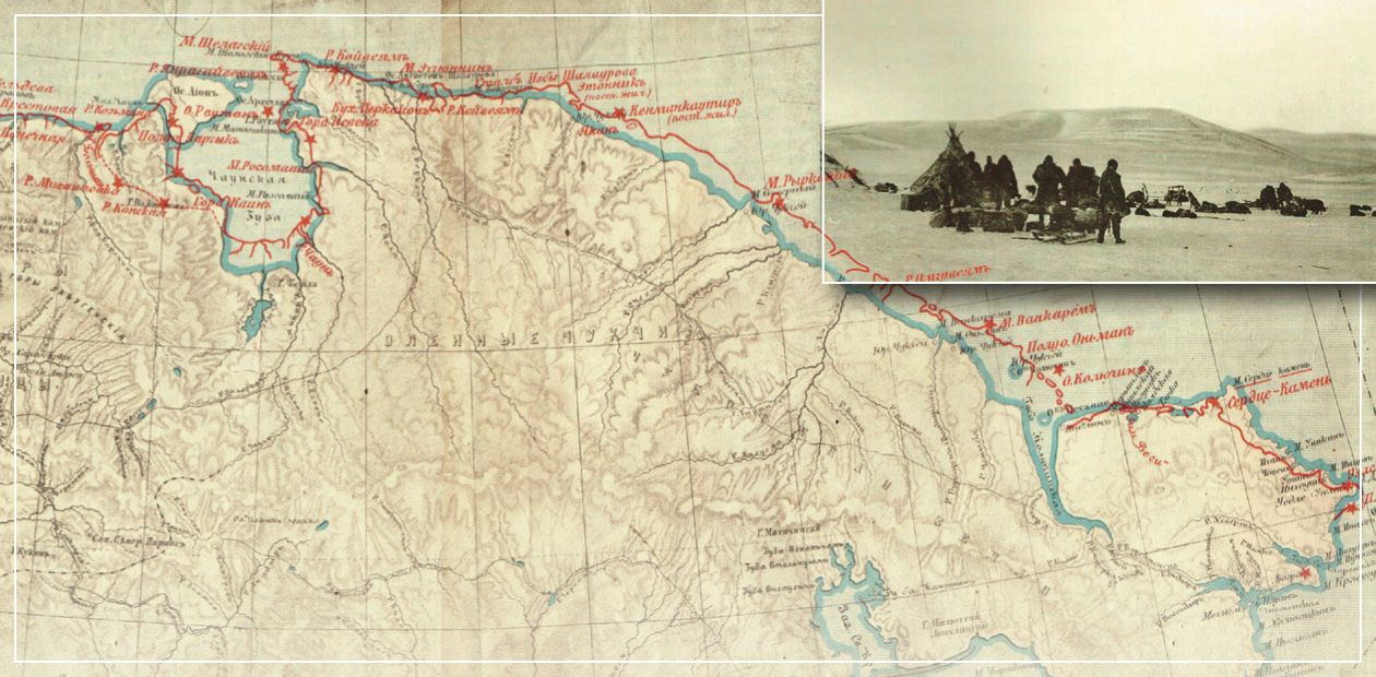
The Chukotka expedition of I. P. Tolmachoff: in search of the Northern Route
In 2013, they celebrated a centenary of the discovery of a large archipelago called the Land of Emperor Nicholas II (since 1930, the Severnaya Zemlya) by the Geographical Expedition of the Arctic Ocean), which marked the finale of the Age of Discovery. This important event initiated the foundation, in 1914, of the standing Polar Commission at the Russian Academy of Sciences aimed at coordinating the investigations conducted by several ministries in the Arctic.
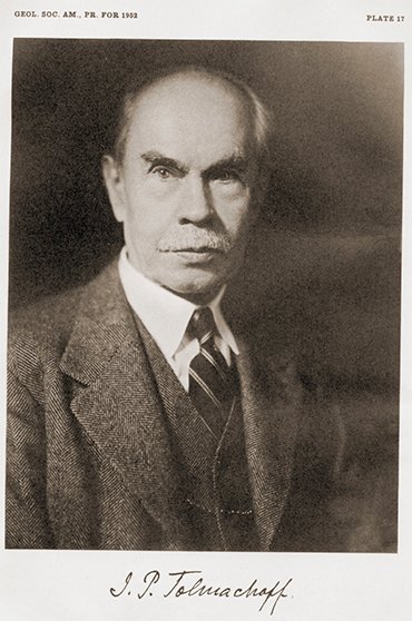
Not many people, however, know that the driving force behind this project was Innokentiy P. Tolmachev, an expert in geological research in Siberia and head of a few important Polar expeditions, including the Chukotka Expedition of 1909–1910 initiated by the Department of Trade and Industry to study the feasibility of the Northern Sea Route, the shortest seaway between European Russia and Russian Far East. In 1922, Tolmachev emigrated from Soviet Russia, which is why for decades the name and achievements of this outstanding Polar explorer have been forgotten
The idea of the [Chukotka] expedition and partially its plan originated from the administration, whereas as a rule the initiator is the explorer himself,” I. P. Tolmachev will write later (Tolmachev, 1911). “The expedition was, so to say, initiated by life itself, by the aroused interest in our half-remembered remote areas, particularly in the North, by the awareness of the weak bonds between these areas and the monopoly, and the need to strengthen these bonds. Among the first actions planned in this field was an improvement of the Siberian transport routes.” This project was a common interest for two ministries, the civil Department of Trade and the military Navy Office.
The Government’s interest in “half-neglected borderlands” was triggered by the tragic outcome of the Russo-Japanese War of 1904—1905. A virtually total absence of transport links with the Russian Far East – impassable overland roads and a long and unsafe single seaway across the Indian Ocean – made cargo deliveries almost impossible.
An alternative to the costly overland link and southern shipping lane could be the north-eastern sea route along the Russian Arctic coast. The nautical survey started by the Navy Office in 1894, which in ten years covered the vast expanse stretching from the Kola Peninsula to the Yenisei estuary, showed that an annual voyage across the Arctic Ocean from Europe to the Yenisei and Ob was practicable. However, further research was hampered by the Russo-Japanese War, and so knowledge about this part of the northern seaway remained exceptionally scarce.
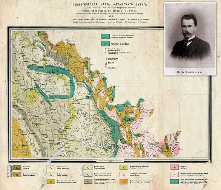
INNOKENTIY TOLMACHEV – A SCIENTIST AND A TRAVELERTolmachev developed his scholarly interests quite early. Upon graduation from St Petersburg University with First Class Honors, the talented young scientist was invited to work in the Geological Office of the Imperial Yuriev University (today, Tartu University, Estonia). He did not stay there long though: in spring 1898, he received an invitation from the Land and Industry Division of the Cabinet of His Imperial Majesty to set out during the vacation to the Altai okrug (region) for geological studies. The results of the three-month trip were presented in the geological study report and journals, supplemented with the lists of the samples collected, determined elevations and tables of meteorological observations conducted in Barnaul, Tomsk, and at the Neozhidanny mine. The following year, Tolmachev again carried on three-month investigations in Altai (Archive of Tartu University, Estonia); a result of his studies was the Geological map of the Altai okrug (Geol. Part of the Cabinet…, 1905).
Almost immediately after the completion of the expedition, Tolmachev accepted the office of academic custodian in the Geology Museum of St Petersburg Academy of Sciences. The circumstances weighted in his favor, and soon Tolmachev launched an expedition funded by the Russian Geographical Society to the upper reaches of the Tom’ River with a view to exploring the mountain lakes of the Kuznetskiy Alatau.
Shortly, in 1905, the Russian Geographical Society entrusted Tolmachev with leading an expedition to the unexplored areas of northern Taimyr, to the Turukhanskiy krai, to investigate the basin of the Khatanga River. Together with the topographer M. Ya. Kozhevnikov, he constructed the first map of the huge – over 1 million square meters – area, having elaborated the hydrographic system of this region. The most notable achievement of the expedition was the discovery and description of the Anabar Plateau.
The impressive results obtained by Tolmachev, as well as the careful preparation of the expedition and prudence with which the expedition was conducted made him famous among scientists and specialists. This is why it was he, an experienced traveler and a thoroughgoing investigator, who was invited to lead the expedition directly relating to the development of the Northern sea route
Moreover, Russian presence along the Arctic Ocean coast, especially in Chukotka and the Russian Far East, was low profile whereas vigorous trade across the Bering Strait almost posed the menace of the Russian North-East detachment (Garusova, 2001). Hence the urgent need to start commercial navigation there and to provide conditions for the guard ships in this area: Russia’s economic and political interests had to be defended.
Public matter
In June 1906, the Minister of the Navy Vice Admiral A. A. Berilev commissioned the Admiralty Council to explore the possibilities of continuing nautical survey in the Arctic Ocean. Nine months later, Nicholas II was submitted the report“… On the necessity to continue nautical survey in the Arctic Ocean with a view to opening the Siberian Sea Route, the so-called North-Eastern Pass, located in our territorial waters, which is very important for Russia’s strategic and economic interests” (Evgenov, Kupetsky, 2013, p. 3).
At the same time, a decision was made to construct two icebreakers; their design was to be developed by a special committee set up for this purpose, and Tolmachev became a member of this committee, alongside other eminent hydrologists and hydrographers. Primarily, it was planned to explore the navigating conditions in the vicinity of the Taimyr Peninsula (Vilkitsky, 1911). However, soon the issue of the necessity of commercial navigation from the Pacific Ocean to the estuaries of the Kolyma and Lena rivers came to the fore; as a consequence, the exploration of the coast from the Lena River estuary to the Bering Strait became vital.
Promotion of navigation along the Siberian northern coast was also discussed by the Council of Ministers, which charged the Governor-General of Irkutsk with setting up, in Yakutsk, a special committee of “local and invited experts in the North of Siberia” to discuss navigating conditions. According to the members of this committee, the first thing to do was to set up base stations with provisions depots and necessary implements all along the northern coast of East Siberia. However, since “the choice of the location of such stations was purely hypothetical,” it was proposed to organize as soon as possible two reconnaissance land expeditions along the Arctic shore of the Verkhoyansk and Kolyma regions. Simultaneously, the issue of steamship navigation to the estuaries of the Kolyma and Lena rivers across the Bering Strait was raised (Tolmachev, 1911).
Shortly, the Council of Ministers initiated the discussion of these proposals at a special meeting in the Commercial Navigation Department of the Ministry of Trade and Industry, which declined “the immediate establishment of commercial navigation in these unexplored seas” as risky and untimely. At last, it was decided to organize only a land expedition, in 1909, led by Tolmachev.
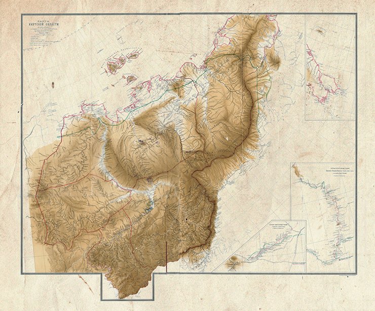
In the same year (1908), the Finance Committee of the State Duma considered the establishment of steam communication between Vladivostok and other ports of the Far East, with an option of extending the Vladivostok – Chukotka Peninsula line to the Kolyma krai (region). To this point, it was needed to obtain as accurate data as possible on the physics, geography, geology, and especially topography of the Arctic Ocean coast. One of the primary tasks of the expedition was the land survey of the coast from the Lena River estuary to the Bering Strait. At a meeting of the Physics and Mathematics Department of the Academy of Sciences, Minister I. P. Shipov, who submitted the request to assign Tolmachev to the Ministry of Trade and Industry, made a point of surveying the entire coastline again (Shirina, 2001).
Difficult start
In summary, the urgent need to survey the Arctic Ocean coast was attributed not only to commonsensical scientific interest but above all to practical need.
This huge section of the country had been the least studied by the beginning of the 20th century (Krasnikova, 2009). The existing maps of this region were based on the data found by the expedition of 1821—1824 led by Lieutenant, Baron F. P. Wrangel, who together with the warrant officer F. F. Matiushkin, succeeded in generating the maps of the coastline from the Kolyma River estuary to the Kolyuchin Bay in a most severe environment, “from the land and in the winter from the ice” (Wrangel, 1841).
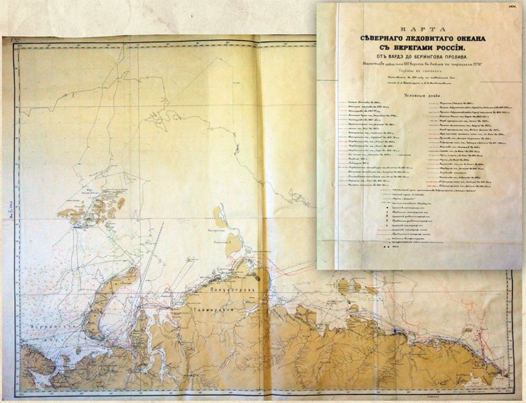
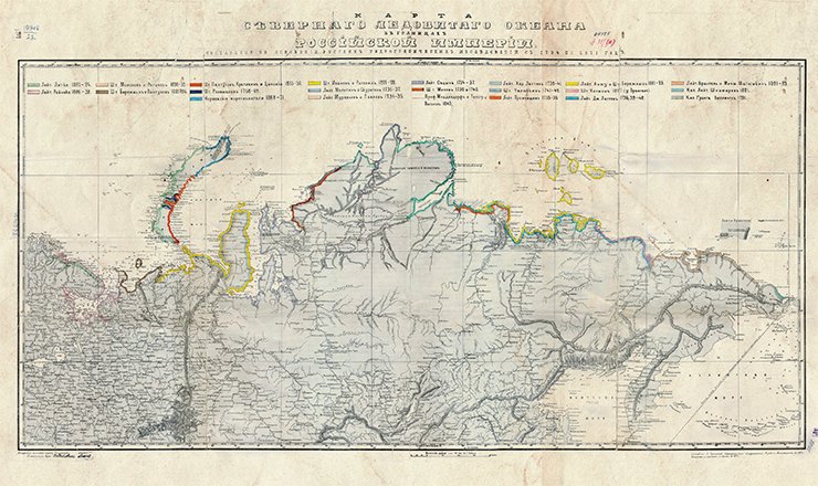
Even on the resulting “Map of the Arctic Ocean within the borders of the Russian Empire constructed on the basis of Russian hydrographic studies from 1734 to 1871,” which contains the data obtained by 22 hydrographic expeditions organized all along the Russian northern coastline, the section from the town of Nizhnekolymsk to Cape Chukotsky is shown based on the data obtained by Wrangel’s expedition. The relatively small section of the northern coast of the Bering Sea, from Cape Serdtse-Kamen to Cape Vostochny is marked as explored by Captain Lieutenant G. S. Shishmarev back in 1821.
No less important was the geological exploration of north-eastern Siberia. The geological study plan prepared by a special subcommittee with the participation of Tolmachev was conveyed to the Mining Department (Izvestiya Geologicheskogo komiteta. 1909. V. 28. N. 1. St. Petersburg). Initially, the expedition was planned to explore the area from the Lena estuary to the Bering Strait. Tolmachev considered it possible provided that the expedition started not later than in February 1909: then, the distance from the Lena to the Kolyma could be covered on sledge in the three spring months, and the coast of Chukotka, in the summer.
However, even though key ministries and government structures were interested in the results of the expedition, launching it took much longer than anticipated. The first meeting dedicated to the organization of the expedition took place as late as December 20, 1908, whereas it took about two months to get from St Petersburg to the nearest point of the route. As a result, the idea of one team making the whole way had to be discarded, and Tolmachev was commissioned to explore the most complicated part of the coastline, from the Kolyma estuary to the Bering Strait, as well as to raise the funds needed for the enterprise.
During the second meeting, on January 30, 1909, it became clear that the necessary funds could not be raised… The question arose: should the survey area be reduced or should the plan to have the expedition in the current year be abandoned at all? Yet the scientists decided to put in for the financial support of the original plan (the route from the Lena estuary to the Bering Strait) but to divide the study area between two teams. Tolmachev was charged with the overall management of organizing the expedition.
The financing issue was resolved only on February 5, 1909 (almost the latest possible departure date from St Petersburg set by Tolmachev!). In effect, its preparation began a month later, when the funds were finally appropriated. “Until then, the expedition could not be considered resolved and, strictly speaking, we could neither make the necessary orders and purchases without a certain risk…nor issue instructions or make orders locally, in the Yakutsk oblast (region)… Naturally, the question as to whether it was possible to launch the expedition in this situation was raised more than once” (Tolmachev, 1911, p. 3—4).
There was virtually no time left to outfit the expedition; however, thanks to the assistance of interested individuals and institutions, they managed to do it within the shortest possible time. Head of the Chief Hydrographic Department A. I. Vilkitsky ordered to furnish maps, books and most instruments, and taught Tolmachev how to perform astronomical observations. The geodesy division of the War Topography Department supplied instruments for the survey, two transit instruments and several chronometers.
 The Yakutsk governor I. I. Kraft sent a telegram to Yakutsk ordering the Captain of Kolyma to make a stock for the expedition, purchase goods, hire reindeer and guides, and arrange a warehouse in the estuary of the Chaun River (a similar telegram concerning the assistance to the western team of the expedition was sent to the Captain of Verkhoyansk). Regrettably, these turned out the only governmental orders intended to help the Chukotka expedition, which worked in the area “very little familiar even to the local population and administration, where Russian influence amounted virtually to nothing” (Tolmachev, 1911. p. 5).
Eventually, the Chukotka expedition comprised two detachments: the Chukotka team led by Tolmachev, with the topographer M. Ya. Kozhevnikov and geodesist E. Weber, and the Lena-Kolyma team led by K. A. Vollosovich, with the astronomer E. F. Skvortsov and topographer N. A. Iyudin.
At the request of the Chief Hydrographic Department, another team was added to the expedition: Deputy Minister of the Navy, Admiral I. K. Grigorovich, commissioned a naval officer to “perform a detailed nautical study of the Kolyma estuary and of the approach route to it from the ocean, and construct the newest sea maps” (Sedov, 1917, p. 3). The head of this team was G. Ya. Sedov, who had participated in the Arctic expeditions before, and his assistant was boatswain’s mate V. Zhukov. This small detachment was to encourage the resumption of the work of the Arctic Ocean Hydrographic Expedition suspended six years before. By the beginning of 1909, the expedition vessels, called the Taimyr and the Vaigach, had nearly been constructed, though they failed to put out to sea at once because of some minor loose ends. The plan of their work was revised a few times, and only in August 1909 they set out to the Far East by the southern route, through the tropics.
Three months on the way
In the long last, Tolmachev’s expedition set off. Now we cannot do without a frequent citing of his “Preliminary Report…” entitled “Along the Chukotka coast of the Arctic Ocean” (1911), which has been mentioned above more than once.
On March 3, Tolmachev with his team, E. F. Skvortsov from Vollosovich’s detachment, and G. Ya. Sedov made their way from Petersburg to Irkutsk via Moscow. There, provisions and warm blankets had been prepared for the expedition, as well as wide and deep sledges with a high tail, lined with fabric. The astronomers Weber and Skvortsov set to work at once.
Because of a lack of horses and bad roads, it was decided to go to the expedition area in several teams. Tolmachev came to Yakutsk on March 31, and the astronomers of the expedition, on April 2 and again took observations. Thanks to the assistance of the local administration and some individuals, the necessary goods and provisions were purchased quite quickly and the swollen luggage of the expedition was prepared for forwarding: “Unexpectedly, the purchases had to be essentially increased as nobody in Yakutsk could warrant that I would receive in Sredne-Kolymsk all the goods I ordered from St Petersburg… I could not risk staying without goods there because you cannot visit the Chukchi just with money. So I had to take three hanks of tea and a pound of Cherkess tobacco, which together with other snacks increased our luggage in Yakutsk by six sledges, and we had brought about the same number of sledges from Irkutsk. Plus we had three sledges of our Cossacks and the sledges of three coachmen, so our expedition borrowed more than twenty sledges. All in all, the expedition (including K. Vollosovich’s party) together with G. Ya. Sedov had about forty sledges” (Tolmachev, 1911, p. 8—9).
The journey to Yakutsk went very well but after that there was nothing but trouble. Postmasters said the post house horses were for post and not for expeditions - ulus (settlement) carts should be used for that purpose. When Tolmachev wondered why there were no carts, the Yakuts assured they had not heard about the expedition, and the special messenger who had come to Sredne-Kolymsk in March carrying the travelers’ dispatches had left no orders concerning the journey. “The conclusion they must have made was that the expedition was an inane matter, not worth of being cared about” (ibid, p.14).
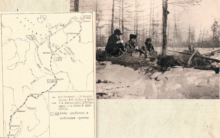
The muddy season began, and things went from bad to worse: Tolmachev and his fellow travelers got stuck at the Dirin-Olomsk post house, 120 versts * from Verkhoyansk, where there were neither deer nor horses. Having got hold of the only horse available, he sent a Cossack with an official paper to seek for a means of transport. “The main symbolic point of this paper was my wax seal with a feather stamped to it – a symbol of urgency and importance of a paper, applied throughout the north of Siberia and well known to non-Russians” (ibid, p.16). Thanks to it, after new adventures, they managed to move on…
Tolmachev arrived in Verkhoyansk on the night of April 18, and a day later Sedov joined him – almost without luggage, just with three sledges loaded with instruments. Sedov’s arrival changed Tolmachev’s plans: originally, he intended to wait for his fellow companions; now, the explorers decided to move on taking any opportunity and at the same time making sure that their colleagues would be able to follow them. As there were not enough horses for the entire caravan, it was agreed to split into several groups.
The next leg of the journey was completed only by May 14. Tolmachev wrote, “It took us 37 days to get from Sredne-Kolymsk to Yakutsk, which, in the opinion of Kolyma citizens, was very quick as in such circumstances it often takes more than two months” (ibid, p.30). The Captain of Kolyma V. Dushkin informed about the approaching expedition, saw about the deer and horses. Also, they managed to make some purchases for the expedition, as a result of which “Sredne-Kolymsk’s stock of butter and sugar became depleted – so slender is the store of the most vital provisions here by spring. Dozens of puds **of dried bread made on our order had only just been baked and sent to Nizhne-Kolymsk…” (ibid, p.30).
The acquisition and repair of boats was a hard task. Dushkin’s letter to Tolmachev mentions the repair of a boat by the craftsman Gambaev, who was paid 15 roubles and “S” bottles of spirit: “only thanks to the latter we managed to talk Gambaev into it; he promised a good job but insisted that he had S bottles. I have no spirit, so I’m sending Gambaev to you with this note, you can do as you please” (St Petersburg Branch, Archive of the Russian Academy of Sciences. Collection 1053. Finding aid 2. # 27). The spirit did not help though: the fixed boat filled with water as soon as it was put afloat.
On May 25, Tolmachev and Sedov left Sredne-Kolymsk on two boats: “We didn’t have a word from our companions, and the local inhabitants thought they had been held back by freshets and wouldn’t reach the town soon. G. Sedov improved his karbass as much as he could by raising the boardsides and equipping it with more comfortable oars and a small gaff-sail, which really dropped a bomb in Kolyma” (Tolmachev, 1911, p. 44). Despite the wind and high wave, they got to a new arm of the Kolyma River, the death place of the well-known explorer of Siberia I. D. Chersky, marked with a plain wooden cross.
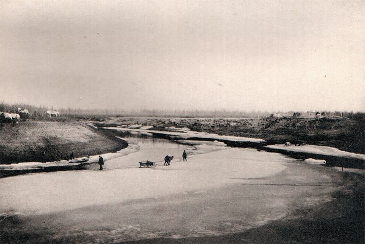
They arrived in Nizhnne-Kolymsk on the night of June 1, and managed to hire an interpreter, Rumiantsev, a Yukagir by nationality. On the morning of June 8, Tolmachev was going by boat down the Kolyma, and in four days he made it to Sukharny, where he joined his fellow travelers who had arrived there the day before. On June 22, the expedition set off to the Laptev light house, where they were to start their observations.
It took the travelers three months and a half just to get to the start point of the planned route. The nightmare with roads and transport was aggravated by adverse weather: an early mud season, river overflows, and strong winds. As a consequence, the expedition made it to the Laptev light house a month and a half later than planned. The biggest problem was to hire Lamut workers: with great difficulty, Tolmachev talked six men and a woman into taking part in the expedition. According to local practice, the latter was charged with putting up a raw-hide tent and looking after the clothes and footwear of all expedition members (ibid, p. 42—43).
Along the coast of Chukotka
On June 23, the expedition members finally set to work. Load was distributed among the horses and deer, and the expedition headed east. The caravans were a nuisance: the deer were mostly old and exhausted, and half-wild horses were trained to get used to the bridle right before the journey.
The first stopping place was near the estuary of the Medvezhaya River, where the expedition took its final shape: “Apart from the three of us, there were two horsemen, an interpreter, a Cossack and seven Lamuts–14 people all in all. We three stayed in two tents, the bigger of which, where E. F. Weber and M. Ya. Kozhevnikov slept, served as a common area when we camped. The Lamuts lived in the raw-hide tent, and the Russian workers were lodged in the so-called “canopy” – a small tent of daba, almost cubical in shape, fit only for sleeping because of its size but giving protection against the rain, wind, and most importantly, mosquitoes” (ibid, p. 46).
“The expedition now moved as follows. I set out on a deer in the company of a Lamut, also riding a deer, and a pack-deer carrying the tools and collections we gathered. I rode or walked along the shore, very close to the water. M. Ya. Kozhevnikov also went along the coastline with another Lamut, but in a sledge, though he had to leave it even more often than I had to dismount the deer. The caravan led by E. F. Weber, as a rule, went in the depth of the tundra as the shore was sometimes cliffy and impassable… there were many small rivers… M. Ya. Kozhevnikov and I used our canoe. Sometimes, when it was heavy ground, we walked and the pack-deer carried the load. When we were discussing the expedition beforehand, we assumed that advancement along the coast would take longer than the progress of the caravan. In fact, it has turned the other way round. Thanks to the unwinding coastline, the way along the shore would be almost the shortest way were it not for the hurdles mentioned above. Because of them, the caravan had to move far from the shore, going round the rivers or coastal mountains. Moreover, without proper supervision, people halted unnecessarily often, as though passively protesting against this summer march, totally weird for them.
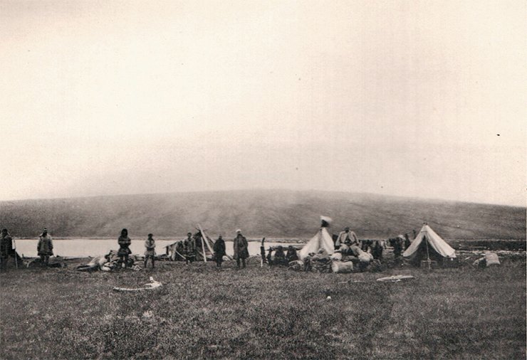
As a result, M. Ya. Kozhevnikov and I, moving not faster than you can go on foot working all the time, not only did not hinder the progress of the expedition but very often came to the agreed place for the night much earlier…” (ibid, p. 47—48).
Later on, Tolmachev and Kozhevnikov separated: Tolmachev went with the worker Shkulev, who led a horse with a load and a box with a chronometer. When there were outcroppings on the shore, Tolmachev dismounted and walked for many miles.
Delineating the coastline more accurately was not an easy task: “We got entangled in numerous large and small lakes, little bays and river arms, extensive marshes and so on. It was very difficult to see where the coastline actually was, and in our survey we marked the shore with a dotted line” (ibid, p. 55). The turmoil with tundra rivulets ended before the town of Kain, where the mountains approach the shore… Among the locals hired for the expedition, Tolmachev singled out the Chukchi Yermankau and his stepson, whom he called “a lucky exception.” They “found fords, if there were any, helped to take the load across, looked after me when I, observing the outcroppings on steep shores, waded round cliffy bays, helped with the deer and horses when we stopped for the night and when we broke camp and moved on – in a word, they behaved like members of the expedition, and all that they did absolutely selflessly unless one counts the meals I gave them” (ibid, p. 57).
On August 3, the travelers stopped for the night on the left bank of the Chaun River, and on the morning of the following day they were at a subsistence warehouse, where the Cossack Kipriyanov and the interpreter Berezhnov had been waiting for them all summer. There, Tolmachev began preparations for the winter journey: bought the hides of young reindeer for good winter wear and chamois leather for a tent. The changeable weather did not afford tours about the surrounding area, and one had to watch out for the clear sky to perform astronomical observations.
On August 16, Tolmachev sent the Lamuts and deer with a small load to Cape Shelagsky, under the supervision of Kipriyanov, having left all the horses for Kozhevnikov and himself, and in two days two heavily loaded bidarrahs controlled by Weber and Berezhnov continued their way.
Right before the departure, the horseman Shkulev was taken seriously ill. The work could not wait, so Tolmachev decided to go with Kozhevnikov, leaving Shkulev on the Chaun on the hands of Rumiantsev. Now his small team had just one horseman who had to look after “14 half-wild horses which had had a good two-week rest and had half forgotten their short-term training, and loads for eight horses” (ibid, p. 62). Now Tolmachev had to lead four pack-horses: “… We slowly moved on, the more so that the southern and south-eastern shores of the Chaun Bay are low-lying, so I could fully devote myself to being a horseman, not distracted by geological exploration (ibid, p. 63).
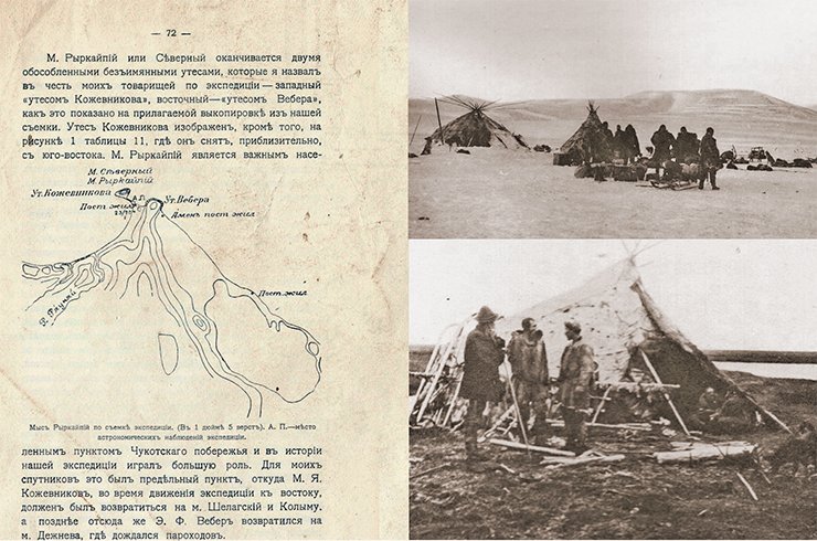
On September 2, the expedition got to the River Yanragayveyam near Cape Shelagsky. It was necessary to think about the winter transport and to purchase sledge dogs. Part of the load and comprehensive natural science collections was sent back, to the Kolyma estuary. In the second half of October, the team approached Cape Ryrkarpiy (Northern), from where Kozhevnikov, who had frostbitten hands after the Khatanga expedition of 1905, returned to the Kolyma, taking with him the gathered ethnographic collections.
Tolmachev and Weber moved on, and on November 11 reached Cape Serdtse-Kamen. Extremely long distances, continual moves and adverse weather made the travelers virtually stop the survey, which had been done systematically up to this time. For the same reason, Tolmachev’s geological exploration “lost any consistency and coherence.” Fortunately, this part of the coast “was more accessible for a traveler” and had been surveyed before, and the explorers managed to provide the missing astronomical points.
There, the explorers found out that the Shilka vessel, sent by the Navy Department, had already been at the cape and had left. It was charged with taking the members of the expedition on board at the beginning of September and bringing them to St Petersburg. Not having found Tolmachev and his fellow travelers, the vessel went back to the Arctic Ocean, where it ran into ice, turned back and went to the southern waters (Starokadomsky, 1915. p. 66).
The travelers went on, and on November 19 arrived at a small Russian settlement, the Dezhnev station, where they received a warm welcome from a small Russian colony. They stayed there till December 5 because of the continuous blizzard, Weber’s disease and the necessity to hire new dogs as the Chukchi who had come with the expedition immediately went back.
Tolmachev’s Chukotka expedition was scheduled to go east from the Kolyma River estuary, rounding the Chukotka Peninsula. However, because of the great difficulties faced by its members, the itinerary was completed at the Bolshaya Kuropatochya River (St Petersburg Branch, Archive of the Russian Academy of Sciences. Collection 47. Finding aid 2. # 152. Sheet 3).
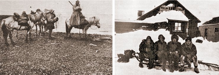
On December 6, Tolmachev and Berezhnov set off home. “We submitted entirely to Chukotka practices, leaving long before dawn and took the ordinary way. The whole coast was familiar to us now, and everywhere we were welcomed amicably” (Tolmachev, 1911, p. 71). On the way, Tolmachev found out about the famine, which Kozhevnikov had experienced together with the local population, near Cape Shelagsky. A few sledges with new dogs were sent to Kozhevnikov and to Weber, who was catching up with a big load.
On February 11, Tolmachev left Sredne-Kolymsk. The way back turned out very easy: everywhere, the travelers were provided full cooperation to the extent that “it was difficult to recognize that these helpful and eager to please post house keepers were the Yakuts we had met previously. A circular letter about the expedition by the Yakutsk Governor had been sent all along the way, and it was a totally different story” (ibid, p.14—15).
On April 3, 13 months after the departure, Tolmachev and Kozhevnikov came back to St Petersburg. In August, having made his journey via Vladivostok, Weber came back (ibid, p. 82).
Results
Organizational issues prevented Tolmachev from the immediate processing of the expedition results. As there was huge interest in the data obtained, Tolmachev had to speak about the expedition again and again, beginning from the way back home. “One can see what great interest the local residents have in potential navigation from the following fact: In February 1910, on their way back through Yakutsk, members of the Chukotka expedition shared their insights on potential trading along the Chukotka coast in the Kolyma estuary and on their hopes that such trading was feasible. On April 15, i. e. six weeks later, several young businessmen inspired by the results of the Chukotka expedition started a commercial association named Kolyma-Chukotka Partnership” (ibid, p.117).
As early as in 1911, the first passage from Vladivostok to the Kolyma River estuary took place, executed by order of the Ministry of Commerce and Industry by Rear Admiral P.L. Troyan on the ordinary merchant ship Kolyma, which carried the government-owned cargo of provisions and essentials.
The events of the recent years – the Chukotka expedition, resumed Hydrographic expedition of the Arctic Ocean, and passage from Vladivostok to the Kolyma estuary – were so important that on December 3, 1911, the Chief Hydrographic Department held a meeting dedicated to the Northern Sea Route, attended by ministers and members of the State Council and State Duma (Russian parliament, 1905—1917). In his talk, Tolmachev emphasized the contribution made by the Chukotka expedition, establishing its connection with the results of Hydrographic expedition of the Arctic Ocean designed to find the Northern Sea Route. The greater part of his talk, however, was dedicated to the urgency of research into the Taimyr and description of the condition of the area he had explored (St Petersburg Branch, Archive of the Russian Academy of Sciences. Collection 269. Finding aid 3. # 6).
Apart from the many talks, Tolmachev as the head of the expedition did routine work: calculated the expedition’s expenses and amounts intended for gifts to the Lamuts; counted the expenditures on prepress of expedition photographs and maps, on copying the diary and so on (St Petersburg Branch, Archive of the Russian Academy of Sciences. Collection 1053. Finding aid 2. # 4).
Nor did he leave his science and popular science activities – within a short period, he published several important works. Most importantly, in April 1911 he completed the journal of the expedition so frequently quoted above, “Along the Chukotka coast of the Arctic Ocean: a preliminary report by the leader of the expedition that explored the Arctic Ocean shore from the Kolyma estuary to the Bering Strait, launched in 1909 by the Commercial Navigation Department of the Ministry of Trade and Industry.”
This detailed narration abounding, among other things, in the details of everyday life and supplied with a lot of remarkable photographs was published by Tolmachev at his own expense and was not for sale – he just gave the book to those who were interested…
The journal dwelt on the expedition’s everyday life: the colossal non-stop organizational work the leader of the expedition had to do from hiring people and purchasing provisions to the delivery of equipment and gathering collections… Tolmachev had no time to write in detail about his geological explorations and made brief notes such as “As I was waiting for the colleagues, I decided to start geological works from Sredne-Kolymsk and managed to make a brief acquaintance with the structure of the Kolyma banks, or its right bank, to be exact, since the left bank is lowland and alluvial along the whole length” (Tolmachev, 1911, p. 33, 64).
And yet, the scientific results of the expedition were impressive. The reconnaissance survey of the five-verst scale was conducted along the entire length of the coast from the Kolyma estuary (Laptev light house) to Cape Chaplin, and a survey from the River Bolshaya to the Chaun River estuary. The survey was made based on 24 astronomical points; its aggregate length was 2,550 versts. Also, astronomical points were determined and the contour of the shoreline from the Kolyma River estuary to Cape Dezhnev was drastically edited (ibid).
URGENT RUSSIAN BUSINESSSpeaking about the Chukotka Peninsula, I said nothing about its population, and so I intend to do it now. The entire north of Siberia is populated with nomadic and vagrant indigenous dwellers. On the Chukotka Peninsula live the Chukchi, who wander to the west of the Kolyma. In the basin of this river, you can also find the Lamuts (the Evens) and a few tribes now almost extinct. To the west, the Lamuts give way to the Dolgans and Tungus, who, to the west of the Khatanga, in their turn, give place to the Samoyedic people. Besides, throughout the north between the Anabar and the Kolyma there are quite a few Yakuts.
Russian population is present on the Kolyma, in the estuaries of the Indigirka, Yana, Lena and on the Yenisei. On the Khatanga, Anabar and northern Yenisei Russians have died out, as they are dying out presently on the Indigirka.
The conquest and, to a certain extent, colonization of Siberia went through the north, and trading with Europe was partly done by sea, with Russian and foreign ships going as far as the Yenisei. The Cossacks-conquerors and their descendants settled down along this way close to the northern coast, apparently because it was profitable for them. However, the government soon stopped navigation in the Arctic Ocean and directed all traffic to Siberia by the southern Vladimir Highway. As a result of this decision, the North was impoverished straightaway as it had to receive whatever was required from the south, which in view of the huge and desolate territory is even today a Herculean task. The first to go were Russian settlers as the most maladjusted and living in most remote habitations. Indigenous dwellers, thanks to their subsistence economy, were in a less vulnerable position, though they had acquired some habits from the newcomers and could barely manage without tea and tobacco, indispensible for any Siberian indigenous dweller, and this is why for them, too, the abolishment of the Northern route was a heavier blow than one could have anticipated.
Except for the shoreline Chukchi, who live to the east of Cape Shelagskiy and survive mainly on soap [apparently, fat is meant – author’s note] of the sea animals, all north Siberian indigenous dwellers are reindeer herders, with the exception of the poor and those who settled near Russians. For all of them, the northern tundra is a foster-nurse, and they move to the forests in the south only for the winter.
All this population relies exclusively on the Siberian railroad, and the enormous distance from it boosts megalomaniacally the cost of goods brought to the North, on the one hand, and, on the other hand, prevents taking out low-value commodities. Vladivostok imports meat from Australia while on the Arctic coast propagate herds of many thousands of reindeer, which nobody can either cure or control. The Arctic Ocean is a natural base for indigenous people in their subsistence economy. It goes without saying that it should be the base of their commodity exchange too, and this can be achieved only through the proper shipment of goods by sea to the northern coast, where these goods will quickly oust the expensive goods coming from the south.
It can be expected that regular navigation along the Arctic coast will result in an increase of the Russian population, or its appearance in the places where it is absent. The North is not as poor as many think but to live there relying only on the faraway railroad is very difficult and expensive. The Americans benefit from supplying their commodities to the eastern part of the Chukotka Peninsula and actively make their way to the west, towards the Kolyma, where one of them even got an exclusive commercial privilege, which he did not use though. Therefore, the establishment of commercial enterprises is not just a matter of industry – it is a national business, which is not as costly as may seem. If we count how much it costs to provide annual assistance, not nearly sufficient, to starving Kolyma and expenses to ensure provisions, not sufficient either, for the relatively large Cossack population, and take into account the difference in the prices of goods shipped by sea and by land, the extras will not be high, and will be needed only at first; shortly, there will not be any extras, and the northern routes will transport cheap commodities in good supply and will not cost the state an odd kopeck.
Advocating the northern sea route, I am happy to realize that I am not alone because I know that among those present here there are people who are in favor of the idea of the Northern Sea Route and there are many advocates of this idea behind these walls. We are all ready to promote this idea to the best of our ability and knowledge, in word and deed, without regard to our own life, if necessary. This way is strewn with graves, but it does not scare us – what scares us is the indifference of the society, which is much more difficult to overcome than the polar conditions. However, here, too a new era must be dawning. The representatives of the society present at this meeting were, largely, the initiators of the meeting.
I hope to God that the interest in the Northern Route does not subside and the society regard the efforts made towards this end as an urgent matter and a Russian business. This is our belief, our hope and our award for the work done and for the past disappointments” (Tolmachev, [1911], St Petersburg Branch, Archive of the Russian Academy of Sciences. Collection 269. Finding aid 3. # 6)
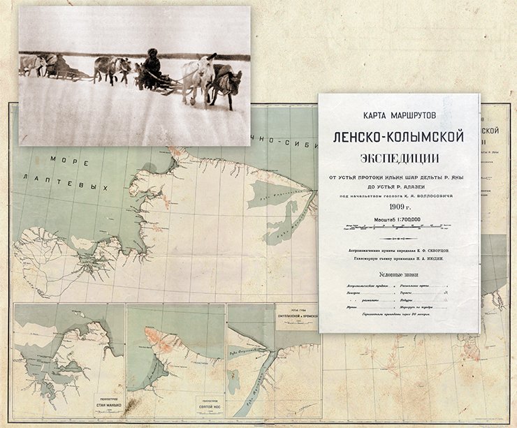
Tolmachev compared the results obtained with Wrangel’s maps, which proves again that at the time there were no later cartographic documents related to this area. Tolmachev enclosed to the Preliminary Report the Operational map of 1909 Chukotka Expedition, constructed based on the expedition materials by the Corps of Topographical Engineers, which showed the profoundly altered position and contour of the shoreline all along the coast from the Kolyma River to the Bering Strait.
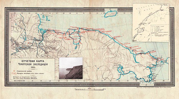
Also, data on the condition of the sea ice and possibility of navigation along these shores were obtained; physical and geographical features of the “Chukotka land” (Tolmachev, 1910), as the part of north-eastern Siberia to the east of the Kolyma River was then called, were described. Virtually all along the expedition route, geology observations were conducted, and, among other things, the issue of the presence of oil deposits in this region was raised.
The lithologic collection gathered by Tolmachev and paleontological material including wood debris from the post-Pliocene deposits of the Arctic Ocean coast, fossil moose and mammoth from the same deposits and Devonian petrified remains from the rivers Kolyma and Dogdo were sent to the Geological Museum, the same as the collections brought by G. Ya. Sedov, where they were partly catalogued and studied.
The slow movement of the expedition caravan allowed Tolmachev to make “in passing” most interesting ethnographic observations relating to the everyday life of the Lamut and Chukchi, their family life, customs and trade relations with other peoples including Americans. As a result, he concluded that it was necessary to start importing Russian goods and organize commercial voyages between Vladivostok and Kolyma, which would serve “not to strengthen but to restore the Russian influence and involve this remote region in cultural life,” without, however, revolutionizing the traditional way of life of the Chukchi, which had formed over centuries and perfectly suited local conditions (Tolmachev, 1911, p.104).
Soviet time
On the completion of the expedition, Tolmachev started preparing the expedition materials for publication: a detailed draft report comprising the journal notes is kept at the St Petersburg Branch, Archive of the Russian Academy of Sciences (Collection 1053. Finding aid 2. # 3). He intended to publish the scientific results of the expedition and an expanded report with an ample historical background and extensive bibliography later on, but the First World War and then the events that followed the October Revolution of 1917 interfered with these plans. In 1922, Tolmachev emigrated to the USA, leaving his motherland for good, and there had been no call for the scientific results of the Chukotka expedition until the mid-1920s.
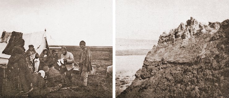
In his correspondence with his son, geographer and explorer of the North A. I. Tolmachev, Tolmachev the emigrant often came back to the issue of completing the processing and publishing of the expedition results. Meanwhile, the well-known Soviet geodesist and hydrographer V. V. Akhmatov took up processing the astronomical determinations of the expedition, and the famous hydrometeorologist L. F. Rudovitz was engaged in the meteorological determinations.
By 1924, when this work had been almost completed, at the First Congress of Soviets of Yakutia, an idea of the scientific study of the territory of the Yakut Republic came up, which would improve its economy and culture of the peoples inhabiting it. It was the Secretary of this congress to whom Kozhevnikov filed an application to the effect that “in connection with the planned activity of the Yakutia expedition of the Russian Academy of Sciences,” it was imperative to publish the proceedings of the Chukotka expedition led by I.P. Tolmachev, which had been conducted exclusively within the borders of the present-day Yakut Republic.
Thanks to energetic activity of the full-time ambassador of the YASSR (Yakut Autonomous Soviet Socialist Republic) at the Presidium of VTsIK (All-Russia Central Executive Committee) M. K. Amosov, the Academy of Sciences started publishing the works about the YASSR “concerning all aspects and not published yet” including the materials of the 1909 Lena-Chukotka Expedition led by I. P. Tolmachev and K. A. Vollosovich. The materials of the Kolyma detachment led by K. A. Vollosovich were published in 1930 and made Volume 15 of the Commission’s Proceedings of the Studies of the Yakut ASSR. Because of the name of the expedition the 1909 Lena-Kolyma Expedition led by K. A. Vollosovich it was almost impossible to relate them to Tolmachev’s Chukotka Expedition.
The collection of drawings of the Chukotka expedition entitled The Chukotka Expedition of 1909—1910. An album of illustrations and maps was published only in 1935 as an appendix to Issue 18 of the Polar Commission Proceedings. There is nothing surprising about it as the Polar Commission was set up on Tolmachev’s initiative, and he was the Commission’s secretary up to his departure.
The story of this publication is connected with an interesting discovery made a few years ago in the Cartographic Archive of the Polar Commission, St Petersburg Branch, Archive of the Russian Academy of Sciences, of several dozen drawings showing the northern coastline from the Kolyma River estuary to the north-easternmost tip of the Chukotka Peninsula. The sheets were in prime condition, the coastline was detailed, a lot of local geographical names were plotted but none of the sheets was dated (Krasnikova, 2012). Further research showed that these maps were indeed processed results of the survey conducted by the military topographer M. Ya. Kozhevnikov and geodesist E. F. Weber during the Chukotka expedition of 1909—1910 led by the geologist I. P. Tolmachev.
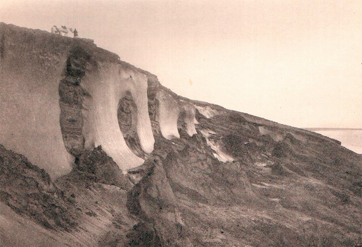
Data about the time when these drawings were printed were obtained from the Index of the cartographic materials of the Arctic ocean (from North Cape to Cape Dezhnev) from 1734 to 1914 kept at the Depot of Navigator Charts and Books of the Chief Hydrographic Department (compiled in chronological order), which was compiled by Staff Captain B. Ewald and came out in 1917. This index was the first in the series conceived for those interested in a detailed study of Russia’s water basin and contained information about all available cartographic materials concerning the Arctic Ocean up to 1914.
It has turned out that the Department of Navigator Charts also had copies of these drawings: “# 546. Copies of the drawings of the expedition that explored the Arctic Ocean coast from the Lena River estuary to Bering Strait led by I. P. Tolmachev in 1909, lithographers…” (Ewald, 1917). This fact suggests that the drawings were processed at the beginning of the First World War.
Why was the publication of these drawings important in the mid-1930s? Apparently, because these cartographic materials retained their relevance and were used to construct new base and detailed maps of the USSR Arctic territories. “Prior to drawing the route, it was used by the Chief Hydrographic Department for map correction. Subsequently, astronomical points were added to the route, and as a result, the route was specified. In 1932, it was used to construct the map of the Yakut ASSR” (Kozhevnikov, 2012, p.15). Note that the drawings were published after the maps based on the data from the drawings had appeared. This must be why the “source document” had to be published.
Materials of the Chukotka expedition were used for other maps of the Soviet Arctic region constructed in those years.
The adverse conditions under which the expedition was organized and conducted, so vividly and in much detail described by I.P. Tolmachev, profoundly affected its schedule. Instead of a detailed exploration of the coast, “the expedition reduced itself to travelling along and exploring the shoreline from the Kolyma to Cape Dezhnev” (Tolmachev, 1911, p. 83). The results of the expedition, however, disagree with Tolmachev’s modest evaluation of his achievements.
And in any case, was it possible to do more in those conditions and at that time? The members of the expedition were the first to walk all along the incredibly extensive stretch of the Arctic coastline with an extremely complicated natural environment. A most important achievement of the expedition is the survey of one of the most difficult to access areas of Russia’s northern coastline, which has allowed a substantial refinement of the maps of the Arctic and obtaining additional physical and geographic data to demonstrate the feasibility of navigation from Vladivostok to the estuaries of the Northern rivers.
* A verst was a Russian unit of distance equal to 1.067 kilometers
** A pud was a Russian unit of weight equal to sixteen kilograms
References:
Garusova, L. N. Russian-American relations in the Far East: the past and the present (late 18th-20th cc.): Historical experience. Vladivostok, 2001. 180 p.
Krasnikova, О. А. Geologist and paleontologist I. P. Tolmachev and the Chukotka Expedition of 1909—1910// People with a great sense of duty. Petropavlovsk-Kamchatsky, 2009. P. 134—139.
Tolmachev, I. P. Along the Chukotka coast of the Arctic Ocean: Preliminary report of the head of the expedition for the exploration of the Arctic Ocean coast from the Kolyma estuary to the Bering Strait conducted in 1909 by the Commercial Navigation Department of the Ministry for Trade and Industry: with an enclosed map, 11 tables and 1 map in the text. St Petersburg: Econom. Typo-lit., 1911. 151 p.
Vilkitsky, A. I. A brief historical overview of the hydrographic papers on the exploration of the Arctic Ocean coast. (Report by Lieutenant General A.I. Vilkitskiy of 3 Dec. 1911). St Petersburg, 1911.
Wrangel, F. P. Journey about the Northern shores of Siberia and the Arctic Ocean made in the years 1820, 1821, 1822, 1823 and 1824 by the expedition led by the Navy Captain Lieutenant Ferdinand von Wrangel. St Petersburg, 1841. 737 p.
Yevgenov, N. I., Kupetskiy, V. N. Expedition of the century: Hydrographic expedition of the Arctic Ocean on the ships Taimyr and Vaigach in 1910—1915. St Petersburg: Russian State Museum of Arctic and Antarctic, 2012.
Supported by the grant of the Russian Foundation for humanities (Grant # 14-03-00699)


