


The Kashmir Diary
A discovery is only the beginning of a journey. Two decades have passed since the termination—against our will—of the Pazyryk studies on the Ukok plateau in the Altai Mountains. The last four years we have been working in India. Someone far from archeology could be astonished at such a leap in geography: What could the Altai nomads and the ancient civilizations of India possibly have in common? Back then in Altai, over twenty years ago, we only pulled a thread in the skein of questions that arose from our lucky finds. Today we have no doubt that a connection exists between the Pazyryk culture and the ancient civilizations of the Middle East. It is the hope to find traces of this connection that led us to Kashmir
A journey of a thousand miles begins
with a single step.
Dao De Jing by Lao Tzu
The long-term interdisciplinary studies of the undisturbed “frozen” burials attributed to the Pazyryk culture on the Ukok plateau in the Altai Mountains produced important results for which we still have no clear explanation. For example, when we restored the Pazyryk costume and horse harness, we obtained compelling evidence that this culture put a priority on textiles over leather, suede, or fur, which would have fitted more logically into the habitats of the Pazyryk people, i. e., high-mountain valleys of Altai (Polosmak and Barkova, 2005). An even greater surprise came from the study of textile dyes from the Pazyryk tombs. It turned out that the woolen fabrics and felts were dyed with the world’s best dyes of plant (dyer’s madder and dyer’s woad) and animal origin (cochineals), which were, however, not typical of this region.

The Pazyryk textiles suggest a highly developed culture of dyeing with natural organic dyes, clearly associated in a complex with the Mediterranean region (Polosmak, Kundo, Balakina, et al., 2006). Moreover, the Pazyryk textile collection includes two shirts from the Second Pazyryk mound (excavations by S. I. Rudenko), made of cotton dyed with Indian madder. This combination of fabric and dye indicates an Indian origin of these items. A shirt of the same style, made of wild Indian silk, was found on the body of a woman buried in Mound 1 of the Ak-Alakha 3 burial site. The Pazyryk barrows also contained such artifacts as an Indian bronze “musical” mirror, kauri shells, and an ornament of stylized lotus flowers and buds.
Many characteristic features of the Pazyryk culture suggest a connection with the Achaemenid Empire, which embraced in the 6th‑4th centuries BCE vast territories inhabited by numerous nations. In 519—518 BCE, some territories of northwestern India also became part of the empire. We cannot study the origins of the remarkable culture that we studied in Altai separately from this ancient civilization, especially if we take into account the latest data from paleogenetic studies (Pilipenko, Molodin, and Romashchenko, 2012).

If the Pazyryk people were one of the Yuezhi nomadic tribal groups (and many scholars believe so), then their fate after they were ousted from Altai in the 3rd century BCE was connected, in one way or another, with these tribes. As is known, the Yuezhi created the Kushan Empire, an ancient state on the territory of modern Central Asia, Afghanistan, Pakistan, and Northern India, which existed from the end of the 2nd century BCE to the 4th century CE. During the heyday of the empire (approximately in the first third of the 2nd century CE, under the rule of Kanishka I), its capital was located in northwestern India, where now stands the modern Peshawar. Kushan kings, known for their tolerant attitude towards religion, endorsed Hinduism, Zoroastrianism, and Buddhism. The trade, economic, and cultural ties between India and Central Asia reached their peak in the Kushan era. The nomads who came to India brought along the tactics of equestrian combat, as well as weapons and horse harness items, and influenced the art of Northern India, represented by the Gandhar and Mathur schools (Litvinsky, 1996).
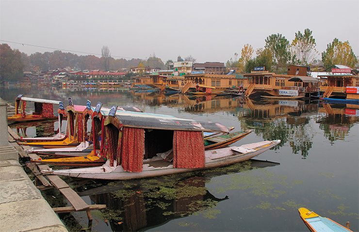

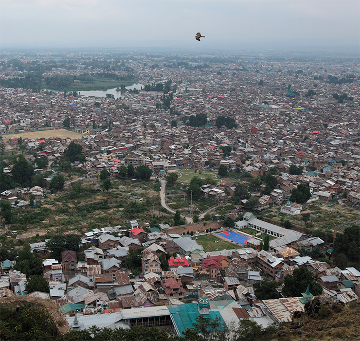
“The modern Srinagar is no more than 150–200 years old. Nothing remains of the old ‘city of the sun.’ Only skeletons are left of the old mosques. The old bridges will soon collapse...,” wrote Nicholas Roerich in 1925. Throughout its long history, the city had been shaken repeatedly by earthquakes and floods. Thus, according to eyewitness accounts, the earthquake of 1804, which lasted seven days and nights, left the city in ruins. In 1815, the British took control of the city and began to rebuild it to match their own tastes and needs. After the flood of 1894, Srinagar was almost completely rebuilt by the colonial forces.
, one of the students who attended our classes on archaeological drawing. She draws these buildings, creating new images of the old city. After receiving a bachelor’s degree in business administration, the artist returned to the university, now to the department of visual arts: “I draw when I want to express my feelings. Art helps me become a better person”")
Floods are a frequent disaster in this ancient city, which literally stands on water—the remains of the old city stand on the two banks of the Jhelum River, called by Roerich “the nerve of Kashmir.” Numerous canals cross the city, whose main attraction lies with the two lakes—Dal and Nigeen—the center of life for many local people. In September 2014, a flood submerged Srinagar by half, leading to loss of life and great destruction. Even after a year, we could clearly see traces of the flood on the walls of the hotel where we stayed
It is the “Pazyryk trail” that led us to Kashmir. When studying cultures in the places of their autonomous existence, like in Altai, I always wonder: Is it really true that this world with its unique style, with its traditions and rituals, with its history, could have dissolved? If so, then I want to go all the way to those places where their presence is still visible and their role is still significant, even if they were only a small group of tribes within a horde on one of its numerous migrations to new lands. This chapter in the history has not finished yet.
Kashmir expedition
Lying between the Great Himalayas and the Pir Panjal Ridge, the Kashmir Valley is the most developed area in the Indian state of Jammu and Kashmir. More than a third of its population lives here, in this valley that has a quarter of all the croplands and orchards in the state.
An ancient route passed through the Kashmir district of Bandipora, creating a link between Kashmir and the Great Silk Road and connecting South–East Asia and China with the Mediterranean countries. The entire area holds great promise for archaeological research aimed at restoring the ancient migration routes of the population that lived in Central Asia and northwestern India. The Gilgit-Baltistan territory (Pakistan), which borders Bandipor, has become a source of numerous archaeological finds suggesting the Central Asian contacts of the local population in different historical periods.

The trade route connecting Kashmir and Central Asia could have had a major outpost at Ahan, now an archaeological site on the ancient portion of the Silk Road. Ahan lies 20 km northwest of Srinagar, near the village of the same name, and half a kilometer from the Jhelum River, which takes its source from the Central Himalayas and has its mouth on the territory of modern Pakistan. Still navigable today, this river served in ancient times as a connecting artery of a huge region by creating a cultural space around itself. Today, as in antiquity, the Jhelum River feeds a network of large irrigation canals.
Ahan was discovered in 1962 by Prof. F. M. Hassnain, Director of the State Archives, Archaeology Research and Museums (India). During exploratory excavations at the site, he found terracotta tiles with analogues in the existing materials from known Kushan monuments in the Kashmir Valley. To date, terracotta tiles with images of people, animals, plants, and abstract drawings have been found at 11 archaeological sites in the Kashmir Valley.
After 1962 there have been no archaeological excavations at Ahan.

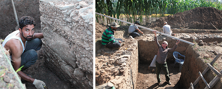
Our team first came to Ahan in October 2015. At this time of year, fields are free of crops, so we were able to examine the condition of the soil, identify the relief signs of the monument, conduct geophysical surveys, and make a topographic plan of the site.
Nowadays, the vast Ahan site lies under agricultural land. Almost nothing has remained of its natural terrain except for embanked boundary lanes. The soil consists of moist clay and contains numerous inclusions of baked clay and fragments of ceramics. All these circumstances complicate greatly the work of archaeologists, so we decided to use magnetometry for the search and identification of objects. Moreover, we needed to conduct a tacheometric survey of the site to constract a topographic plan so that we could tie together the geophysical work sites and future excavation sites and link them to the terrain.

It is very important that our studies at Ahan have been interdisciplinary from the very beginning: such an approach fundamentally changes the strategy of archaeological research and improves the quality of excavations. Through the use of magnetometry, we were able to detect archaeological objects remotely, without destroying the cultural layer, in the area long used for crops and managed to determine the planigraphic features of this complex. Based on magnetic susceptibility measurements, we made a high-quality forecast for sources of the observed positive and negative magnetic anomalies, which was fully confirmed by the results of preliminary archaeological excavations.
Excavations at Ahan
In 2017, we returned to Ahan to conduct archaeological excavations and collect information necessary for further interpretation of the geophysical results. We also intended to determine the cultural identity of the site and date the constructions. Students of the University of Kashmir excavated the most promising site, where in 2015 we identified geometrically clear contours of two or three structures.
Dig Site 1, which produced the most interesting results, lay at a place where magnetometry located a U-shaped structure with stone walls of a meter width. Immediately after the removal of the upper arable layer, researchers discovered a horizontal surface with stone debris. After removing the stones, it became clear that they belonged to the top part of a wall.

The walls themselves showed very neat stonework: they were built as a monolith from rubble with sharp edges alternating with large and small boulders of gray marble-like limestone. This construction material could have come from a local source—there is a low mountain range about 10 km north of Ahan. The large boulders showed, obviously, no signs of hammer-dressing at all; being of different sizes and configurations, they all had one side with a flat “front” surface. The smoothness and evenness of the wall surface indicated the use of formwork and mortar to fasten the stones and rubble.
This masonry is most reminiscent of that known from John Marshall’s excavations at Taxila, one of the most important cities in the historical Gandhara region in modern Pakistan. Digging up various archaeological sites at different times over 20 years, this British archaeologist identified several types of masonry associated with certain historical periods. Based on the data obtained, the stone structure at Ahan can be dated to the period from the 3rd century BCE to the 1st century CE.
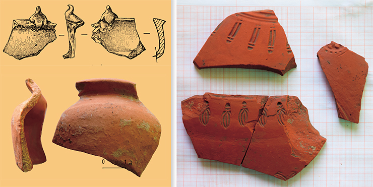
The first complex is associated with the lower layer of the rubble heap over the destroyed building, where archaeologists found parts of trays, fragments of glasses with gray and red engobes (coating of liquid clay applied before firing), and parts of jars with a very good dense engobe and glossing of excellent quality. They also discovered fragments of lamps shaped as plates with smoked edges. By analogy with the pottery of northern and eastern Afghanistan, this complex can be dated both to the end of Indo–Scythian period and to the reign of the first Kushan kings, i. e., the 1st century BCE to the 1st century CE. This dating is partly confirmed by a random discovery at Ahan of a coin associated with the Kushan king Vima Takto.
The second complex is associated with the layer above the base of the stone wall and with the rubble heap under a layer of fired bricks and tiles. The complex is represented by vessels of very good quality with a bright terracotta shard at the fracture and an engobe of a bright terracotta or red color. The finds include fragments of shaped bowls; vessels with spouts, stamps, drawn symbols or a swastika; fragments of an elegant small cup with a double-sided engobe and polishing and a lid with a cone. All this suggests a special purpose of the objects as well as the building where they were used. This complex can be attributed to the period of the great Kushans, i. e., to the 2nd century CE, as evidenced by a random discovery of a coin of Kanishka I, the most famous ruler of the Kushan kingdom.
The third pottery complex dates back to the time when the building was destroyed and its stone walls were reused. The complex includes a vessel found in the niche of a stone wall at Dig Site 1 and container vessels with a flat outward rim and covers from Dig Site 3. By analogy with the pottery of northern Peshawar, this complex can be dated to the 3rd century CE
After the clearing, it turned out that the wall had a double structure, its interior filled with stones and soil. This circumstance, along with the thickness, suggests that the stone walls most likely served as a basement that carried rammed-clay walls supporting the roof. Such a strong and technically advanced basement could certainly support a very heavy roof.

We still do not understand the purpose of this structure—our finds give no definitive answer to this question. To date, we have been able to identify three periods of settlement at the Ahan site from the data on ceramics, the main and only category of finds at the site. In each of these periods, ceramic items repeat themselves, to a certain extent, both in types of vessels and in vessel-making technique, which makes it possible to tie these ceramic complexes together. Based on the data obtained, we can identify three consecutive time periods in the existence of the monument, from the end of the Indo–Scythian period to the end of the Kushan period. Further studies of the site and its ceramic complexes will make it possible to more accurately determine not only its dating, but also the functional purpose of the structure with the stone basement.
One of the outcomes of the joint Russian–Indian archaeological studies in the state of Jammu and Kashmir, which began in 2015, was that two years later, the University of Kashmir organized, for the first time in its history, a group of students specializing in archaeology, who took part in the excavations at the Ahan site in 2017. For the young people, this was the first experience of working at an archaeological monument, during which it became clear that for further independent work, they needed to acquire solid skills of field and laboratory research.
Thus, a decision was made to organize an archeological school for students of the University of Kashmir. The school took place in the summer of 2018 at the Center for the Study of Central Asia with lecturers from the Institute of Archaeology and Ethnography (Novosibirsk). The teaching course included lectures and practical training sessions on the most essential issues of fieldwork and materials processing.
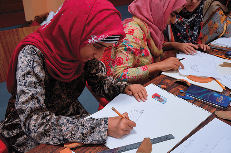
The students saw in practice the principles of dig site demarcation, leveling, and excavation planning. Ceramics is the most widespread material at archaeological sites in the Kashmir Valley; therefore, the curriculum paid special attention to working with ceramics. A lecture on the basics of archaeological drawing was complemented by classes on drawing ceramic items (these classes were especially popular among the students), whereby each student tried to achieve a better result, following the instructions of Elena Shumakova, an artist specializing in archaeology. Since archeologists very rarely retrieve unbroken ceramic vessels, it was very important to teach the students to assemble from shards if not a whole vessel then at least a part of it, so that one could determine the original shape of the object. Practical training sessions aimed to develop skills in this difficult craft. Lyudmila Kundo, an experienced chemical engineer and restorer, delivered a lecture on primary conservation of finds directly in the field.
Upon finishing the school, each student received a certificate. This was the first step in building a team that could take part in large-scale research work in Kashmir. After all, our knowledge about the amazing history of this region comes mainly from written sources and may benefit greatly from archaeological research, which not only corrects and complements the existing knowledge but also brings new discoveries.
As regards our research, the Kushan monuments in the Kashmir Valley may represent a continuation of the history of the Pazyryk nomads but in a different historical context—in the same way as the possible Pazyryk trail in the cultures of Tibet. Chinese sources give evidence that a part of Yuezhi, called the “small Yuezhi,” fled from the Xiongnu to the south, to Tibet, where they lived subsequently together with the Tibetan Qiang. However, this is a different story.
References:
Litvinsky B. A. India and Central Asia // Aziya – dialog tsivilizatsii (Asia as a Dialogue of Civilizations). Moscow: Giperion, 1996, pp. 153–193 [in Russian].
Polosmak N. V., Kundo L. P., Balakina G. G., et al. Tekstil’ iz “zamerzshikh” mogil Gornogo Altaya IV–III vv. do n. e. (opyt mezhdistsiplinarnogo issledovaniya)(Textiles from the Frozen Tombs of the Altai Mountains, 4th–3rd Centuries BCE: An Interdisciplinary Study), Novosibirsk: Sib. Otd. Ross. Akad. Nauk, 2006 [in Russian].
Rtveladze E. V. Velikii indiiskii put’: iz istorii vazhneishikh torgovykh dorog Evrazii (The Great Indian Road: From the History of the Major Trade Routes of Eurasia). St. Petersburg: Nestor-Istoriya, 2012 [in Russian].
Rudenko S.I. Kul’tura naseleniya Gornogo Altaya v skifskoye vremya (The Culture of the Inhabitants of the Gorno–Altay during the Scythian Period). Moscow and Leningrad, 1953 [in Russian].
The director and participants of the international project “Archaeological Studies of Migration Routes between Central Asia and Kashmir in Ancient and Medieval Times” thank the administration and sponsors of the Gerda Henkel Stiftung Foundation (Düsseldorf, Germany) for supporting the studies in the Kashmir Valley, India. The author is grateful to A. P. Druzhinin (Berlin), a specialist in the Greek–Bactrian and Kushan periods, for his advice on the Ahan ceramic complex.
The publication uses photos made by the author and other members of the team


")


